
Quick locating method based on GEO constellation coarse location for Beidou receiver

A positioning method and rough positioning technology, applied in satellite radio beacon positioning systems, measuring devices, instruments, etc., can solve the problem of increased search calculations

Active Publication Date: 2015-08-26
湖南中电星河电子有限公司
View PDF4 Cites 15 Cited by
  • Summary
  • Abstract
  • Description
  • Claims
  • Application Information

AI Technical Summary

Problems solved by technology

The above methods all have constraints on the user's approximate position, that is, only when the receiver's approximate position estimation error does not exceed 150km, can the satellite be quickly recovered in millisecond integer time, and the search calculation amount will increase sharply when the probability position is unknown

Method used


Image

  • Quick locating method based on GEO constellation coarse location for Beidou receiver
  • Quick locating method based on GEO constellation coarse location for Beidou receiver
  • Quick locating method based on GEO constellation coarse location for Beidou receiver

Examples


Embodiment Construction

[0063] Below in conjunction with accompanying drawing, the present invention is described in detail:

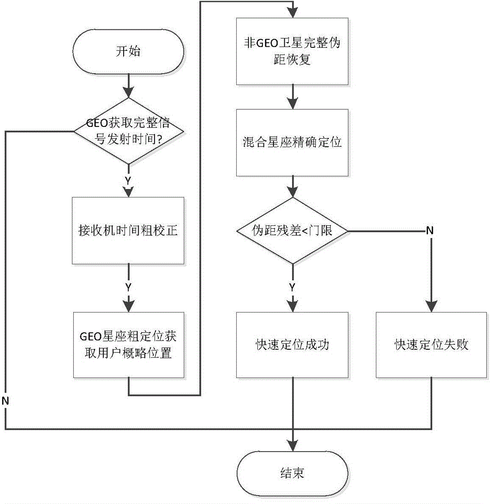
[0064] figure 1 It is a schematic flow diagram of the principle of the technical solution of the present invention, as shown in the figure, comprising the following steps:

[0065] Step S1, judging whether the frame synchronization of the GEO satellite is completed, and acquiring the launch time of the satellite. After the navigation signal is captured and tracked, the signal must be bit-synchronized and frame-synchronized to obtain the signal launch time and achieve the final positioning.

[0066] The invention can perform fast positioning after the GEO satellite realizes the frame synchronization. The bit synchronization method can use the traditional histogram method, and the frame synchronization algorithm can also use the conventional four-step inspection method to check whether the frame synchronization is completed: 1. Search for the frame synchronization code; 2. Ve...


PUM


Abstract

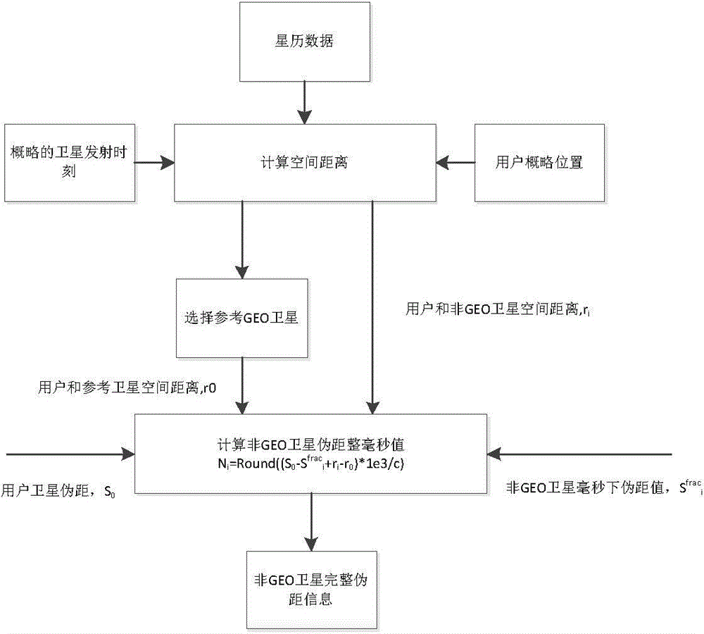
The invention provides a quick locating method based on GEO constellation coarse location for a Beidou receiver by use of the characteristic that the GEO satellite in the hybrid constellation of the Beidou system is high in message rate, and solves the problem that when the outline coordinates of a receiver are unknown, the millisecond recovery algorithm for the traditional GNSS signal transmitting time cannot be applied due to a leap of calculated quantity. When the outline coordinates of the receiver are completely unknown, the GEO satellite of which the signal transmitting time is completely acquired is used at first for coarse location, then the millisecond integer time of the sending time of a non-GEO satellite is recovered according to the outline coordinates acquired by coarse location, and finally, all the visible satellites are utilized for accurate location. The quick locating method can achieve millisecond recovery of the non-GEO satellites which finish capture when the Beidou system only finishes frame alignment of GEO constellation, so that the time to first-time location of the receiver when the satellite ephemeris is known is earlier.

Description

technical field [0001] The invention relates to the field of Beidou navigation receiver development, in particular to a method for improving the first positioning time of the Beidou receiver, which can be applied to specific research and development of various Beidou navigation receiving terminals. Background technique [0002] Time to First Fix (TTFF) is an important performance index of a navigation receiver, and improving the time to first fix of a navigation receiver plays an important role in improving device experience. [0003] Factors affecting the time of first positioning include satellite ephemeris acquisition time and observation pseudorange acquisition time. The acquisition time of satellite ephemeris can be shortened by storing broadcast ephemeris, extended ephemeris in the receiver, or generating extended ephemeris independently by the receiver. The satellite pseudo-range is obtained through the local time and the satellite signal launch time. The satellite s...

Claims


Application Information

Patent Timeline
Patent Type & Authority Applications(China)
IPC IPC(8): G01S19/25
CPCG01S19/25G01S19/258
Inventor 吴鹏靖守让刘文祥苏映雪孙广富黄龙刘增军龚航黄仰博
Owner 湖南中电星河电子有限公司
Learn More