A space-borne auxiliary GPS method and system based on dynamic orbit extrapolation

A technology of orbit extrapolation and dynamics, which is applied in the field of satellite navigation and positioning, can solve problems such as loss of positioning, achieve the effects of reducing positioning time, shortening cold start time, and improving positioning accuracy

Inactive Publication Date: 2017-12-05
SHANGHAI ENG CENT FOR MICROSATELLITES
View PDF4 Cites 0 Cited by
  • Summary
  • Abstract
  • Description
  • Claims
  • Application Information

AI Technical Summary

Problems solved by technology

[0006] 2. The low-orbit satellites are in a state of high-speed motion, and the switching of GPS satellites can be seen in the field of view of the satellite-borne GPS receivers faster, which is more prone to loss of positioning than ground-based GPS receivers.
How to design a simple, effective, fast, high-precision, and low R&D cost satellite-borne GPS receiver acquisition assistance system, solve the time-consuming problem of the blind search method, improve the dynamic performance and rapid positioning capability of the navigation and positioning system, and achieve the goal in limited boot time Performing as many GPS positioning measurements as possible during the running time is a new technical challenge for the design of spaceborne GPS receivers

Method used


Image

  • A space-borne auxiliary GPS method and system based on dynamic orbit extrapolation
  • A space-borne auxiliary GPS method and system based on dynamic orbit extrapolation
  • A space-borne auxiliary GPS method and system based on dynamic orbit extrapolation

Examples


Embodiment Construction

[0025] The spaceborne assisted GPS method and system based on dynamic orbit extrapolation provided by the present invention will be described in detail below in conjunction with the accompanying drawings.

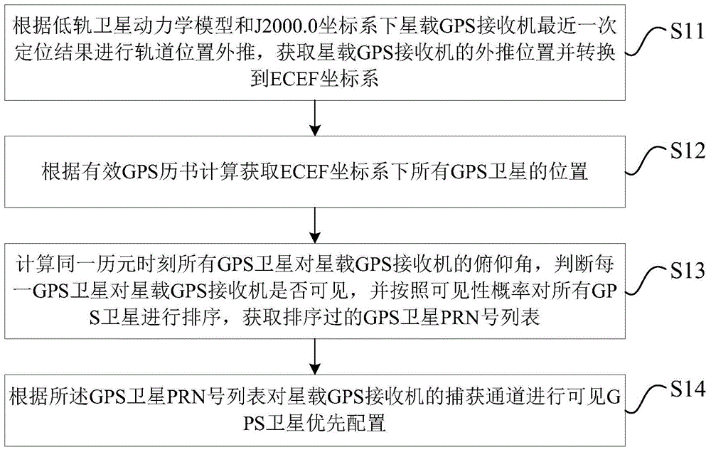
[0026] refer to figure 1 , the flow chart of the spaceborne assisted GPS method based on dynamic orbit extrapolation according to the present invention, said method comprises the following steps: S11: according to the low orbit satellite dynamic model and J2000.0 coordinate system under the spaceborne GPS receiver Extrapolate the orbital position of the latest positioning result, obtain the extrapolated position of the spaceborne GPS receiver and convert it to the ECEF coordinate system; S12: Calculate and obtain the positions of all GPS satellites in the ECEF coordinate system according to the effective GPS almanac; S13: Calculate the same ephemeris The pitch angle of all GPS satellites to the on-board GPS receiver at Yuan time, judge whether each GPS satellite is visible ...


PUM


Abstract

The invention provides a spaceborne auxiliary GPS method based on dynamic orbit extrapolation. The spaceborne auxiliary GPS method comprises the steps that 1) orbit position extrapolation is performed according to a low-earth-orbit satellite dynamic model and the latest positioning result of a spaceborne GPS receiver under a J2000.0 coordinate system so that the extrapolation position of the spaceborne GPS receiver is acquired and converted to an ECEF coordinate system; 2) the positions of all GPS satellites under the ECEF coordinate system are acquired according to effective GPS ephemeris calculation; 3) the pitch angle of all the GPS satellites to the spaceborne GPS receiver at the same epoch time is calculated, whether each GPS satellite is visible to the spaceborne GPS receiver is judged, all the GPS satellites are ranked according to the probability of visibility, and a GPS satellite PRN number list after ranking is acquired; and 4) GPS satellite priority configuration is performed on the capture channel of the spaceborne GPS receiver according to the GPS satellite PRN number list. The number of times of capturing and searching of the spaceborne GPS receiver is reduced so that positioning speed is enhanced.

Description

technical field [0001] The invention relates to the technical field of satellite navigation and positioning, in particular to a space-borne auxiliary GPS method and system based on dynamic orbit extrapolation. Background technique [0002] When the satellite-borne GPS receiver locates, it needs to capture and search all GPS satellites (currently 32) to obtain the PRN (Pseudo Random Noise code) number of the visible GPS satellites; It can be seen that the GPS satellites are tracked, and the positioning solution is performed based on at least 4 GPS satellite signals. In the absence of assistance, the acquisition module of the spaceborne GPS receiver usually adopts a method similar to polling to capture all GPS satellites in turn to obtain visible GPS satellites; this requires a lot of capture search time (for 32 GPS satellites Capture takes about a few minutes), resulting in slow positioning. [0003] Many ground navigation and positioning terminals (smart phones, vehicle-mo...

Claims


Application Information

Patent Timeline
Patent Type & Authority Patents(China)
IPC IPC(8): G01S19/28G01S19/34
CPCG01S19/28G01S19/34
Inventor 尹增山朱淑珍何晓苑齐金玲
Owner SHANGHAI ENG CENT FOR MICROSATELLITES
Why Eureka
Try Eureka