Supercharge Your Innovation With Domain-Expert AI Agents!

System and method for inverting vehicle's own position by using coordinates of traffic signs

A technology for traffic signs and cars, applied in the field of car navigation

Active Publication Date: 2017-12-01
WUHAN KOTEI INFORMATICS
View PDF5 Cites 0 Cited by
  • Summary
  • Abstract
  • Description
  • Claims
  • Application Information

AI Technical Summary

Problems solved by technology

[0003] However, in the existing navigation system, GPS is used to locate the position of the car, and its accuracy can only meet the positioning on the road. The system provides route guidance and can only indicate the direction of the intersection.

Method used


Image

  • System and method for inverting vehicle's own position by using coordinates of traffic signs
  • System and method for inverting vehicle's own position by using coordinates of traffic signs
  • System and method for inverting vehicle's own position by using coordinates of traffic signs

Examples


Embodiment Construction

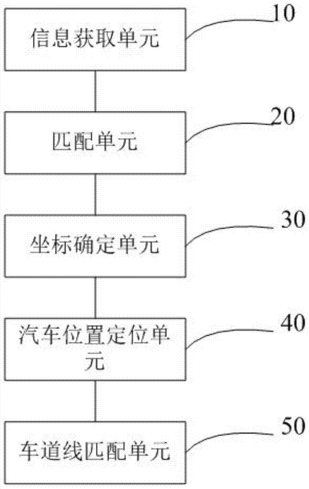
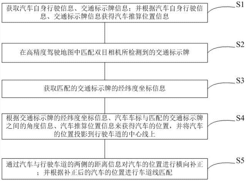
[0021] Such as figure 1 As shown, a system that uses the coordinates of a traffic sign to reversely predict the position of a car itself includes the following units:

[0022] The information acquiring unit 10 is used to acquire the vehicle's own driving information and traffic sign information; and obtain the estimated position information of the vehicle according to the vehicle's own driving information and traffic sign information;

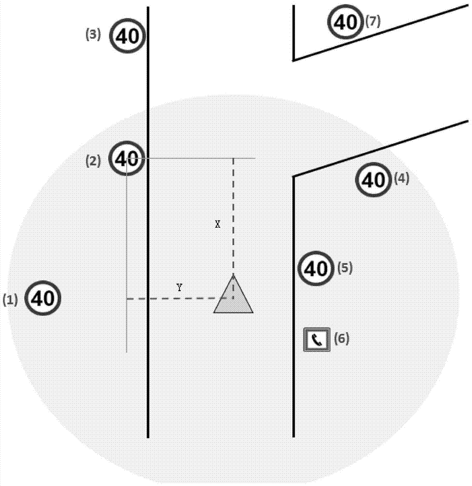
[0023] The matching unit 20 is used for matching the traffic sign detected by the binocular camera in the high-precision driving map;

[0024] The coordinate determining unit 30 is used to obtain the longitude and latitude coordinate information of the matching traffic sign;

[0025] The car position positioning unit is used to obtain the position of the car according to the longitude and latitude coordinate information of the traffic sign, the angle information between the car logo and the matching traffic sign, and the estimated position information o...


PUM


Abstract

Disclosed is a system for reversely educing the position of an automobile by means of the coordinates of traffic signboards. The system comprises an information obtaining unit, a matching unit, a coordinate determining unit, an automobile position determining unit and a lane line matching unit, wherein the information obtaining unit is used for obtaining automobile driving information and traffic signboard information and obtaining automobile educed position information according to the automobile driving information and the traffic signboard information; the matching unit is used for matching traffic signboards detected by binocular cameras in a high-precision driving map; the coordinate determining unit is used for obtaining longitudinal and latitude coordinate information of the matched traffic signboards; the automobile position determining unit is used for obtaining the position of the automobile according to the longitudinal and latitude coordinate information of the traffic signboards, the angular information between an automobile logo and the matched traffic signboards and the automobile educed position information and projecting the position of the automobile onto the center line of a driving lane; the lane line matching unit is used for conducting transverse addition and correction on the position of the automobile according to information of the distance between the two sides of the driving lane and the automobile and conducting lane line matching according to the added and corrected position of the automobile.

Description

Technical field [0001] The present invention relates to the technical field of vehicle navigation, in particular to a system and method for reversely inferring the position of a car by using the coordinates of a traffic sign. Background technique [0002] Car navigation means that after the user arbitrarily mark two points on the car GPS navigation system, the navigation system will automatically design the best route for the car owner based on the current location. [0003] However, in the existing navigation system, GPS is used to locate the car's position, and its accuracy can only satisfy the positioning on the road, and the system provides route guidance only to indicate the direction of the intersection. Summary of the invention [0004] In view of this, the present invention provides a method that can confirm the exact position of the car on the driving map and accurately provide lane-level guidance, so that the driver can drive the car more safely and reliably, and use the c...

Claims


Application Information

Patent Timeline
Patent Type & Authority Patents(China)
IPC IPC(8): G01C21/28
CPCG01C21/28
Inventor 邓前飞
Owner WUHAN KOTEI INFORMATICS
Features
  • R&D
  • Intellectual Property
  • Life Sciences
  • Materials
  • Tech Scout
  • Unparalleled Data Quality
  • Higher Quality Content
  • 60% Fewer Hallucinations
Learn More