Automatic extraction method for block adjustment connection points of SAR image

A technology of block adjustment and automatic extraction, which is applied in the direction of radio wave reflection/re-radiation, using re-radiation, measuring devices, etc. It can solve problems such as inconsistent scales, complex relative deformation, and uncertain initial relative positional relationship of image points. , to achieve the effect of high-precision automatic extraction

Inactive Publication Date: 2015-11-25
CHINESE ACAD OF SURVEYING & MAPPING
View PDF4 Cites 5 Cited by
  • Summary
  • Abstract
  • Description
  • Claims
  • Application Information

AI Technical Summary

Problems solved by technology

[0004] In order to solve the above-mentioned technical problems existing in the prior art, the present invention proposes a SAR image automatic matching method that integrates multivariate information. Image matching overcomes the problems of scale inconsistency, complex relative deformation, uncertain initial relative positional relationship of image points, difficulty in matching non-feature points, and large amount of matching calculations in SAR block network image matching, and realizes SAR image block adjustment Efficient automatic extraction of connection points

Method used


Image

  • Automatic extraction method for block adjustment connection points of SAR image
  • Automatic extraction method for block adjustment connection points of SAR image
  • Automatic extraction method for block adjustment connection points of SAR image

Examples


Embodiment Construction

[0026] The present invention will be described in further detail below in conjunction with the accompanying drawings.

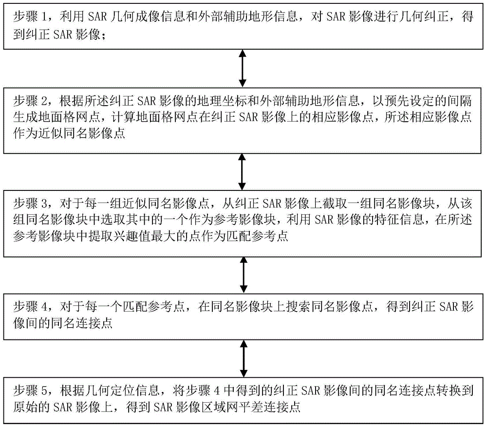
[0027] Such as figure 1 As shown, the SAR image block adjustment connection point automatic extraction method of the present invention adopts the following steps to carry out:

[0028] Step 1, use the SAR geometric imaging information and external auxiliary terrain information to perform geometric correction on the SAR image to obtain the corrected SAR image.

[0029] Among them, step 1 is specifically: using the geometric imaging parameters of the SAR image and the sensor platform state vector parameters to establish a geometric positioning model, using the geometric positioning model combined with external auxiliary terrain information, that is, the existing DEM (Digital Elevation Model, digital elevation Model, which is a discrete digital expression of topography, is a digital method for spatially describing ground features) data, geometrically corrects t...


PUM


Abstract

The invention provides an automatic extraction method for block adjustment connection points of an SAR image, and the method comprises the steps: obtaining a corrected SAR image; generating ground grid points according to the geographic coordinates and external auxiliary topographic information of the corrected SAR image, and calculating the corresponding image points of the ground grid points on the corrected SAR image; cutting out a group of corresponding image blocks from the corrected SAR image, selecting one corresponding image block from the group of corresponding image blocks as a reference image block, and extracting points with the maximum interest value from the reference image block, wherein the points with the maximum interest value serves as matching reference points; searching the corresponding image point of each matching reference points from the corresponding image block, and obtaining corresponding connection points between corrected SAR images; enabling the corresponding connection points between corrected SAR images to be converted to a raw SAR image, and obtaining the block adjustment connection points of the SAR image. The method improves the automation degree of the block adjustment of the SAR image, and improves the production efficiency of SAR topographic mapping.

Description

technical field [0001] The invention belongs to the field of digital photogrammetry of remote sensing images, in particular to the field of synthetic aperture radar block adjustment processing. Background technique [0002] At present, Synthetic Aperture Radar (SAR) terrain mapping technology has been gradually popularized and applied. In cloudy and foggy areas, the application of large-area SAR mapping is an inevitable trend in the future. High-precision positioning of SAR images is the basis of SAR topographic mapping, but in large-area mapping applications, high-precision positioning of SAR images needs to be realized through block adjustment. The block adjustment is to make full use of the redundant observation information on the connection points of the overlapping areas of the images, solve the model orientation parameters, and achieve high-precision positioning, thereby reducing the demand for the number of control points. Therefore, the acquisition of connection poi...

Claims


Application Information

Patent Timeline
Patent Type & Authority Applications(China)
IPC IPC(8): G01S13/90
CPCG01S13/904G01S13/9027
Inventor 张继贤杨书成赵争黄国满卢丽君程春泉
Owner CHINESE ACAD OF SURVEYING & MAPPING
Why Eureka
Try Eureka