Method for automatically generating geographic maps for large-range complex urban environment

An urban environment and map generation technology, applied in the field of mobile robots, can solve the problems of lack of analysis and full utilization of geometric relationships, low robustness of map representation accuracy algorithms, and low environmental robustness, and achieve a wide range of applicable scenarios , low cost, low time complexity and low space complexity

Active Publication Date: 2015-11-25
成都圭目机器人有限公司
View PDF3 Cites 53 Cited by
  • Summary
  • Abstract
  • Description
  • Claims
  • Application Information

AI Technical Summary

Problems solved by technology

[0007] To sum up, the existing environmental map generation methods mainly have the following problems: 1. The elements of the environmental map are still mainly point clouds or line segments, lack of extraction of higher-level features, and the algorithm complexity is high and robust Poor; 2. Lack of analysis and full utilization of geometric relationships between features at different levels, and various features are still regarded as isolated individuals, resulting in low map representation accuracy and algorithm robustness; 3. Limited to small areas Or indoor environment, because the algorithm has a large amount of calculation, poor real-time performance, and low robustness to the environment, it is difficult to apply it in a large-scale complex urban environment

Method used


Image

  • Method for automatically generating geographic maps for large-range complex urban environment
  • Method for automatically generating geographic maps for large-range complex urban environment
  • Method for automatically generating geographic maps for large-range complex urban environment

Examples


Embodiment Construction

[0021] The method for automatically generating a geometric map of a large-scale complex urban environment provided by the present invention will be described in detail below with reference to the accompanying drawings and specific embodiments.

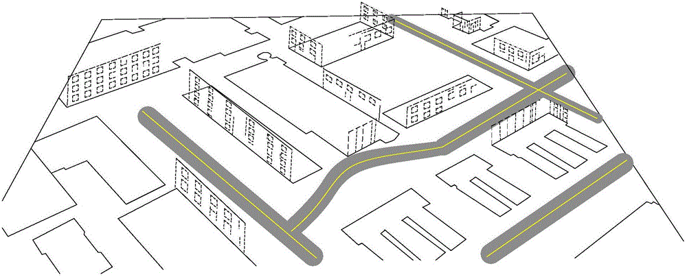
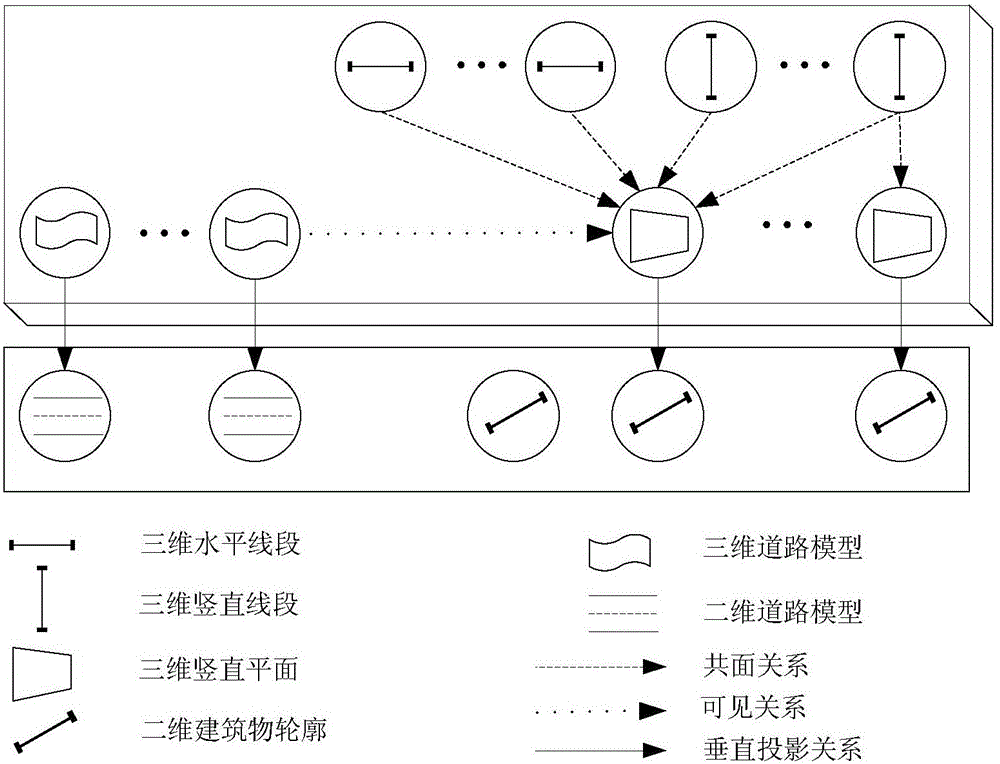
[0022] The large-scale urban environment geometric map involved in the present invention is named Enhanced Geometric Map (Enhanced GeometricMap, EGMap). The schematic diagram of EGMap is as follows figure 1 shown. EGMap contains two-dimensional road map, two-dimensional building overlooking outline information and high-level three-dimensional geometric model (horizontal straight line, vertical straight line and vertical building plane). The geometric relationship between different levels of features in EGMap is as follows: figure 2 As shown, wherein, the two-dimensional building top view outline is the vertical projection of the three-dimensional vertical plane (building side plane); the two-dimensional road model is the vertical pr...


PUM


Abstract

A method for generating geographic maps for large-range complex urban environment includes extracting two-dimensional roads and two-dimensional building contour information, generating a two-dimensional geographic map; a monocular PTZ camera, under the guidance of the two-dimensional geographic map, conducting video acquisition and obtaining video images; extracting key frames from the video images, extracting line segment characteristics of matching adjacent key frames to obtain line segment correspondence, positioning and establishing an environment three-dimensional geographic model based on a mobile robot of matching line characteristics; matching a three dimensional geographic model and the two-dimensional geographic map, determining the corresponding relation between the two, and generating an enhanced city geographic map; and optimizing the enhanced city geographic map based on bundle adjustment algorithm with geometrical constraints. Compared with the prior art, the method is wide in application scope, high in robustness and precision, small in storage space needed, and low in cost.

Description

technical field [0001] The invention belongs to the technical field of mobile robots, in particular to a method for automatically generating geometric maps of large-scale complex urban environments for autonomous navigation of mobile robots. Background technique [0002] Environment map generation is the basis and key to realize autonomous navigation tasks of mobile robots. The representation form of environment map and the method of map construction are the hot and difficult issues in the field of mobile robot research. [0003] With the development of technologies such as intelligent assisted driving and unmanned vehicles, the autonomous navigation of mobile robots in urban environments has received increasing attention, and the generation of large-scale urban environment maps has become a research hotspot. [0004] Existing maps for mobile robots to navigate in large-scale urban environments are still dominated by two-dimensional road and building outline information, wh...

Claims


Application Information

Patent Timeline
Patent Type & Authority Applications(China)
IPC IPC(8): G06T17/05
Inventor 李海丰胡遵河
Owner 成都圭目机器人有限公司
Why Eureka
Try Eureka