
A method and system for presenting an electronic map

An electronic map and stature technology, applied in geographic information databases, structured data retrieval, etc., can solve the problems of inability to control multiple information points at the same time, business processing, and inconvenient operation and display of the same group of information points, so as to reduce the number of groups. Bind work, realize real-time update, operate and display convenient effects

Active Publication Date: 2019-09-06
福建星网物联信息系统有限公司
View PDF5 Cites 0 Cited by
  • Summary
  • Abstract
  • Description
  • Claims
  • Application Information

AI Technical Summary

Problems solved by technology

Since the information point is aimed at the location information of a fixed point, when the user needs to display or operate a group of information points with the same attribute and different positions, the current method is mainly to establish multiple information points in the information point database and create a set of information points for each Each information point is endowed with group attributes (for example, adding a group ID or group name in the information point attribute table, so as to achieve the purpose of identifying the group to which the information point belongs, so as to realize the operation of the same group of information points), so as to This is to achieve the purpose of identifying the group to which the information point belongs, so as to realize the operation of the same group of information points; however, this method needs to establish a binding relationship between each information point and the group, and for each specified information point Specify the group name and group ID. When you need to operate a group of information points, such as displaying, deleting, changing styles, etc., you need to search for all the information points in the group and perform operations one by one. Simultaneously control multiple information points, which brings great inconvenience to the actual business processing and the operation and display of the same group of information points.

Method used


Image

  • A method and system for presenting an electronic map
  • A method and system for presenting an electronic map
  • A method and system for presenting an electronic map

Examples


Embodiment 1

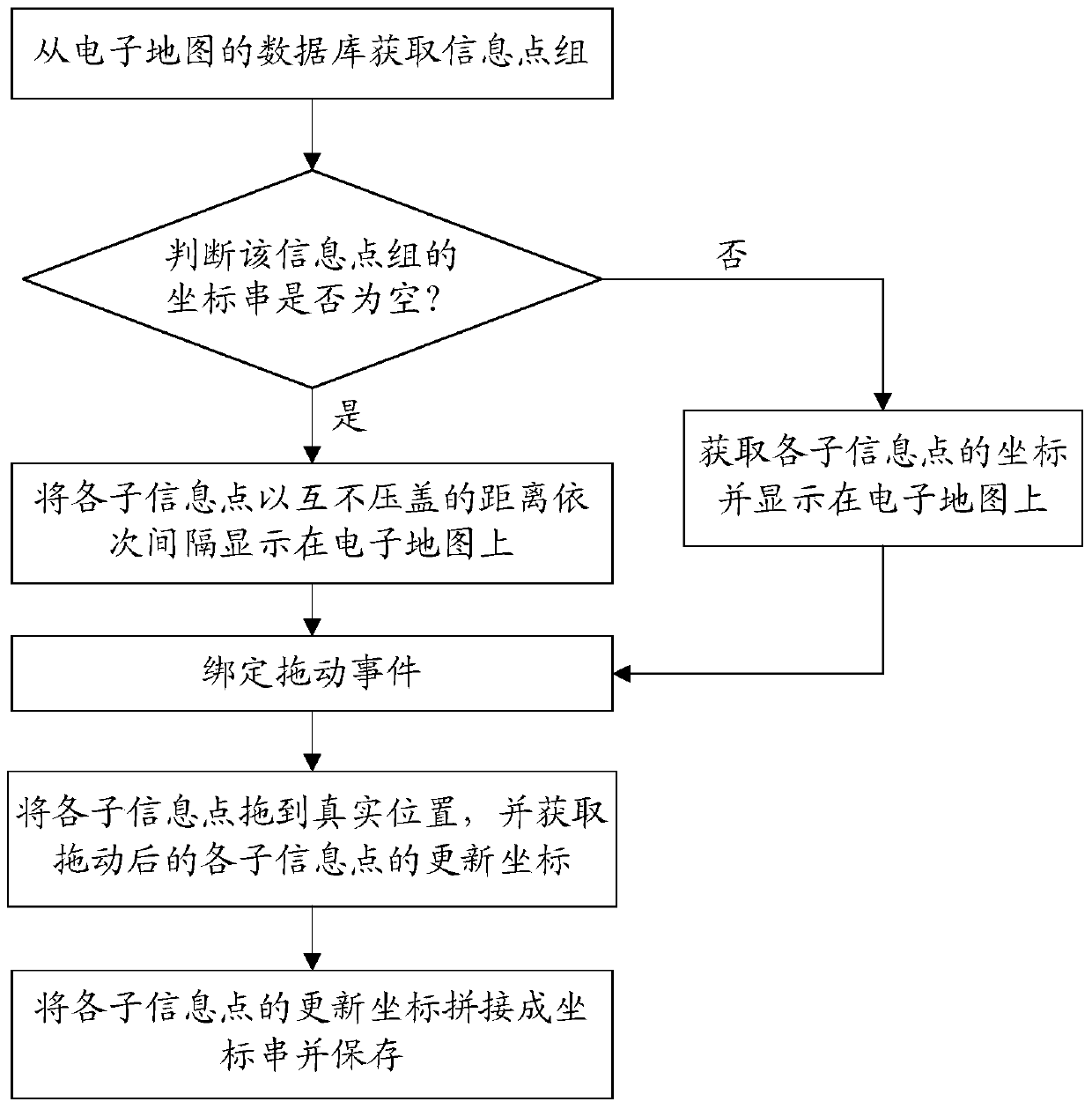
[0043] Please refer to figure 1 As shown, the method includes the following steps:

[0044] Step S1. Create an information point group, and load the established information point group into the database of the electronic map. When creating an information point group, it is necessary to set the name attribute of the information point group to facilitate identification between different information point groups. This step S1 is only executed when an information point group needs to be established.

[0045] Step S2, obtain the information point group from the database of the electronic map, and the information point group includes at least two attributes of the number of sub-information points and the coordinate string; wherein, the attribute of the number of sub-information points is set when the information point group is established; the attribute of the coordinate string It is set when the information point group is obtained for the first time. In the actual implementation, ...

Embodiment 2

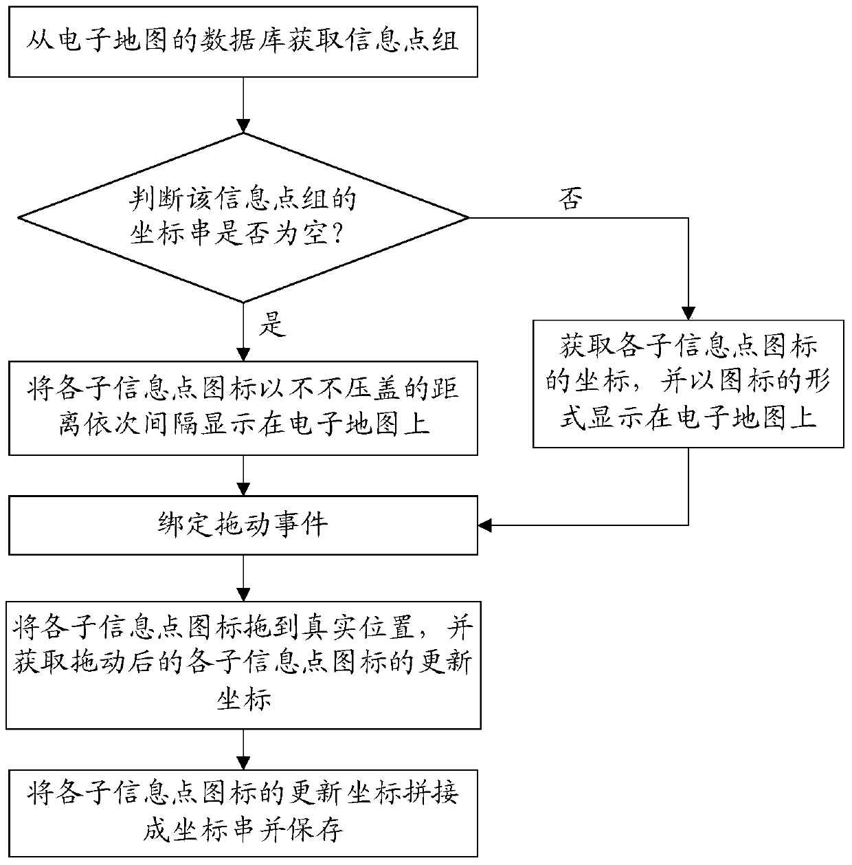
[0061] Please refer to figure 2 As shown, the method includes the following steps:

[0062] Step P1. Create an information point group, and load the established information point group into the database of the electronic map. When creating an information point group, it is necessary to set the name attribute of the information point group to facilitate identification between different information point groups. In specific implementation, one light can be used to represent one sub-information point, so one light group is one information point group. This step P1 is only executed when an information point group needs to be established.

[0063] Step P2, obtain the information point group from the database of the electronic map, the information point group includes at least two attributes of the number of sub-information points and the coordinate string; wherein, the attribute of the number of sub-information points is set when the information point group is established; the at...

Embodiment 3

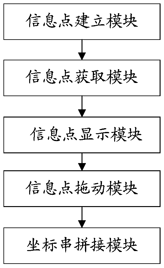
[0079] Please refer to image 3As shown, the system includes: an information point establishment module, an information point acquisition module, an information point display module, an information point dragging module and a coordinate string splicing module;

[0080] The information point establishment module is used to establish an information point group, and load the established information point group into the database of the electronic map. When establishing an information point group, it is necessary to set the name attribute of the information point group to facilitate different information points. Identification between groups. The information point establishing module is only executed when an information point group needs to be established.

[0081] The information point acquisition module is used to obtain the information point group from the database of the electronic map, and the information point group includes at least two attributes of the number of sub-infor...


PUM


Abstract

The invention provides an electronic map presenting method and system. The method includes the steps that information point groups are acquired from a database of an electronic map and at least comprise the number of sub-information points and coordinate string attributes; the sub-information points in the information point groups are sequentially displayed on the electronic map at intervals; the sub-information points are pulled to actual positions, and updated coordinates of the pulled sub-information points are acquired; the updated coordinates of the sub-information points are spliced into a coordinate string to be saved. The electronic map presenting method and system have the following advantages that binding relationship of each information point and the corresponding group category does not need to be established, a user can operate and control one information point group with the same attribute and different positions at the same time, and great convenience is brought to actual service processing and operation and display of the information points in the same group.

Description

technical field [0001] The invention relates to the field of electronic map display, in particular to an electronic map presentation method and system. Background technique [0002] Nowadays, in applications based on electronic maps, in addition to the point of information (POI, abbreviation of Point of Interest) that comes with the electronic map, users often need to add custom information points in the application, wherein each information point is usually Contains information such as name, category, longitude and latitude, nearby hotels, restaurants and shops. In specific use, a certain information point can be intuitively displayed on the electronic map only through the longitude, latitude and name information, and interactive operations can be performed on the information point according to the attributes of the information point (such as display, delete, Modify location, icon style, name, etc.). Since the information point is aimed at the location information of a fi...

Claims


Application Information

Patent Timeline
Patent Type & Authority Patents(China)
IPC IPC(8): G06F16/29
Inventor 魏军福
Owner 福建星网物联信息系统有限公司
Learn More