Aerosol thickness and laser radar ranging delay automatic calibration method

A laser radar, automatic calibration technology, applied in the direction of measurement device, electromagnetic wave re-radiation, radio wave measurement system, etc., can solve the problems of limited accuracy, inability to obtain ranging data, failure of domestic three-dimensional mapping satellite engineering tasks, etc.

Active Publication Date: 2016-04-27
SHANGHAI INST OF TECHNICAL PHYSICS - CHINESE ACAD OF SCI
View PDF4 Cites 8 Cited by
  • Summary
  • Abstract
  • Description
  • Claims
  • Application Information

AI Technical Summary

Problems solved by technology

This method is not suitable for domestic laser altimetry satellites. First, because NCEP is not open to Chinese users in a timely manner, domestic laser altimetry satellites do not perform accurate atmospheric correction due to the lack of atmospheric auxiliary data, so that accurate measurements cannot be obtained. The distance data eventually led to the failure of the entire engineering task of the domestic stereo mapping satellite; the second factor is the limited spatial resolution of NPEC data, and its 1*1° resolution is difficult to distinguish various small clouds on the laser transmission path Wait, atmospheric corrections with NPEC have limited accuracy

Method used


Image

  • Aerosol thickness and laser radar ranging delay automatic calibration method
  • Aerosol thickness and laser radar ranging delay automatic calibration method
  • Aerosol thickness and laser radar ranging delay automatic calibration method

Examples


Embodiment Construction

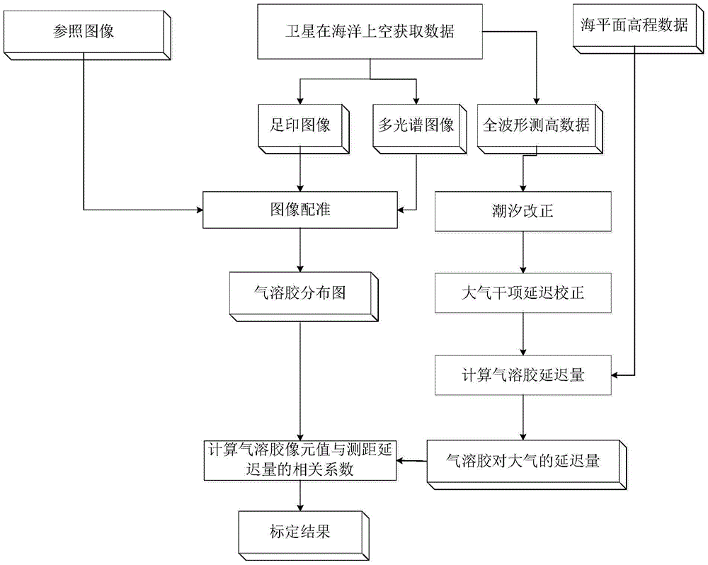
[0034] In order to better illustrate the technical solutions and advantages of the present invention, the implementation process of the present invention will be further described below in conjunction with the accompanying drawings.

[0035] S1 registers the multispectral image of the aerosol thickness to be identified with the auxiliary image.

[0036] Select control points from A and B using the point matching method of the same name. Considering the irregular changes of satellite images due to attitude errors and terrain errors, the number of control points in this area should be properly encrypted for complex areas such as urban areas and mountainous areas when selecting control points.

[0037] S2 For any point on the multispectral image, find the pixel of the same type on the entire image A, and filter out the points with the same category according to the auxiliary image. Determine whether points A and P belong to the same type of pixel according to the calculated simi...


PUM


Abstract

The invention relates to an aerosol thickness and laser radar ranging delay automatic calibration method. The method is characterized in that correlation coefficient is established based on pixel values of aerosol content extracted from images and range error values of the sea surface, and transfer coefficient of the range errors represented by the dimensionless pixel values of an aerosol content distribution diagram, so that accurate correction of height measurement value of the land surface can be realized. The relation between image aerosol brightness values and atmosphere wet delay, that is, aerosol delay amount, is established automatically without ground actually-measured data, thereby realizing accurate atmosphere wet term correction of any height measurement data, and playing an important correction role in correcting the height measurement data of a satellite-borne laser altimeter.

Description

technical field [0001] The invention belongs to the technical field of remote sensing and earth observation, and in particular relates to an automatic calibration method for aerosol thickness and laser radar ranging delay. Background technique [0002] In order to improve the accuracy of stereo mapping satellites, it is urgent to solve the key technical problem of inaccurate data of laser altimeter measurement and ranging. The most important content is to regularly calibrate the water vapor delay of the laser altimetry data, and use this to correct the water vapor delay, so as to obtain accurate ranging data, thereby improving the accuracy of laser ranging. [0003] The existing laser ranging correction technology needs to rely on the accurate atmospheric data provided by NCEP, and then make accurate corrections to the ranging. This method is not suitable for domestic laser altimetry satellites. First, because NCEP is not open to Chinese users in a timely manner, domestic l...

Claims


Application Information

Patent Timeline
Patent Type & Authority Applications(China)
IPC IPC(8): G01S7/497G01S17/08
CPCG01S7/497G01S17/08
Inventor 黄庚华杨贵谢锋舒嵘王建宇
Owner SHANGHAI INST OF TECHNICAL PHYSICS - CHINESE ACAD OF SCI
Why Eureka
Try Eureka