
A Usability Evaluation Method for Open Geospatial Data

A technology of geospatial data and evaluation methods, applied in geographic information databases, special data processing applications, electrical digital data processing, etc.

Inactive Publication Date: 2017-02-22
WUHAN UNIV
View PDF3 Cites 0 Cited by
  • Summary
  • Abstract
  • Description
  • Claims
  • Application Information

AI Technical Summary

Problems solved by technology

At present, the research on the usability of spatial data is in the preliminary exploration stage. Although there are framework studies on the concept of usability and the elements of usability evaluation, there is a lack of a set of feasible usability measurement methods. Therefore, it is necessary to study the usability evaluation method of open geospatial data of great significance

Method used


Image

  • A Usability Evaluation Method for Open Geospatial Data
  • A Usability Evaluation Method for Open Geospatial Data
  • A Usability Evaluation Method for Open Geospatial Data

Examples


Embodiment Construction

[0027] In order to facilitate those of ordinary skill in the art to understand and implement the present invention, the present invention will be described in further detail below in conjunction with the accompanying drawings and embodiments. It should be understood that the implementation examples described here are only used to illustrate and explain the present invention, and are not intended to limit this invention.

[0028] For the convenience of explaining the specific implementation method, take the 2014 OSM road data of Xi'an City including 13 jurisdictions as an example. The data comes from the official website of OpenStreetMap (http: / / www.openstreetmap.org), and the data mainly includes new urban areas 13 districts and counties including Beilin District, Lianhu District, Baqiao District, Weiyang District, Yanta District, and Yanliang District, with a total area of ​​10,108 square kilometers. The reference data is the navigation data of Xi'an City in 2014.

[0029] pl...


PUM


Abstract

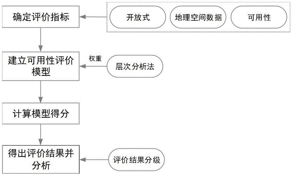
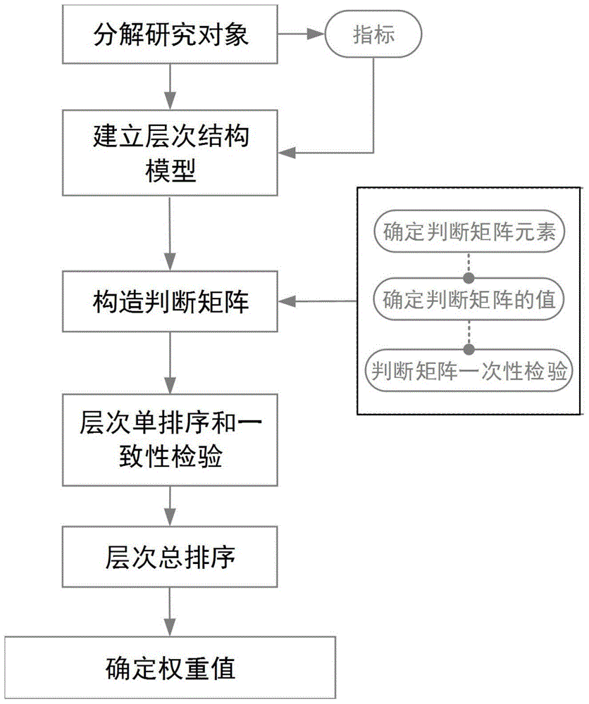
The invention discloses a usability evaluation method for open geographic space data. The method comprises the steps of firstly, determining usability evaluation indexes of the open geographic space data; secondly, according to the evaluation indexes, determining weights of the indexes by utilizing an analytic hierarchy process and establishing an evaluation model comprising the evaluation indexes and the corresponding weights; thirdly, analyzing the usability evaluation indexes of the open geographic space data, carrying out centesimal system scoring, and calculating scores of the evaluation indexes of the model and a total score of the model by referring to the weights corresponding to the indexes; and finally, analyzing the scores of the evaluation indexes of the model and the total score of the model, and determining the usability degree of the open geographic space data by grading. The method can effectively evaluate the usability condition of the open geographic space data.

Description

technical field [0001] The invention belongs to the technical field of geospatial data, and relates to a method for evaluating the availability of geospatial data, and more specifically, relates to a method for evaluating the availability of open geospatial data. Background technique [0002] Geospatial data is data related to geographic location, and 80% of the information in the real world is related to geographic location, so geospatial data is a very important information resource. [0003] With the development of technology and network information technology, there are more and more ways to obtain geospatial data. In addition to traditional technical means such as digitization and field measurement, crowdsourcing geographic data based on technologies such as web2.0 and GPS positioning data), spontaneous geographic information (volunteer geographic information, VGI) and so on have become new hotspots in geographic information science research. At the same time, in the p...

Claims


Application Information

Patent Timeline
Patent Type & Authority Patents(China)
IPC IPC(8): G06F17/30
CPCG06F16/29
Inventor 蔡忠亮李亚平谢彩云刘国炜宛子翔王飞李霖
Owner WUHAN UNIV
Learn More