Content-aware geographic video multilayer correlation method

A geo-video, content-aware technology, applied in video data retrieval, geographic information database, video data browsing/visualization, etc., can solve the problem of lack of semantic and contextual thinking, difficulty in understanding multi-scale complex behavior event information, and difficulty in supporting cross- Space-time region issues, semantic associations, etc.

Active Publication Date: 2016-06-01
WUHAN UNIV
View PDF4 Cites 27 Cited by
  • Summary
  • Abstract
  • Description
  • Claims
  • Application Information

AI Technical Summary

Problems solved by technology

These association methods lack the semantic and contextual thinking of the video content in complex dynamic surveillance scenes in the macro-pattern of geospatial space, and it is difficult to support the semantic association required for cross-temporal issues, especially for multi-scale

Method used


Image

  • Content-aware geographic video multilayer correlation method
  • Content-aware geographic video multilayer correlation method
  • Content-aware geographic video multilayer correlation method

Examples


Embodiment Construction

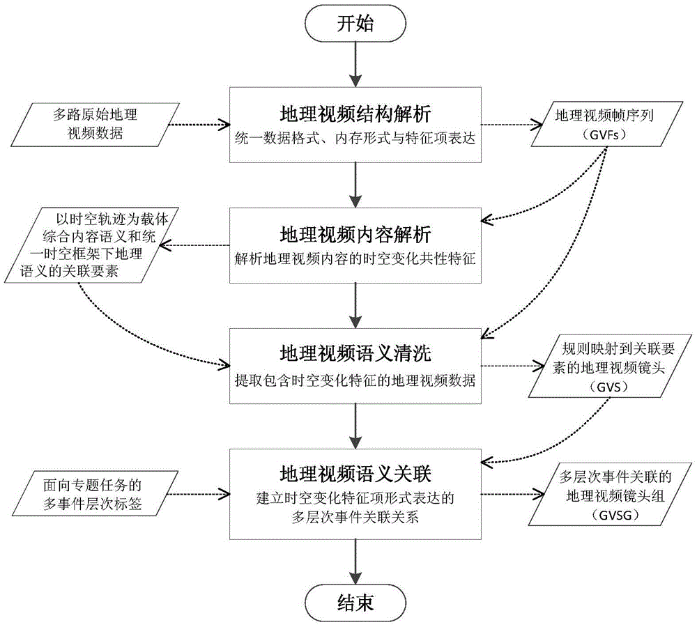
[0058] The present invention provides a multi-level semantic association method for geographic video based on data content perception for multi-channel geographic videos acquired as a whole in a multi-temporal-scale urban environment.

[0059] The principle of the present invention is explained below in conjunction with the drawings.

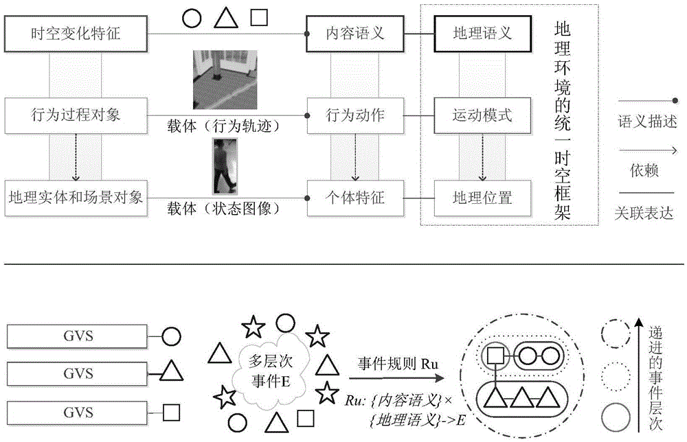
[0060] Such as figure 1 As shown, the principle of the technical solution of the present invention is: to solve the problem of insufficient association ability caused by the existing method using a single spatio-temporal tag association, face the common characteristics of the temporal and spatial changes of geographic video content, analyze the semantics of integrated geographic video content and geographic semantics under a unified reference benchmark The multiple associated elements of the geographic video are stored as geographic video semantic metadata; in this process, the trajectory object that integrates spatial, temporal and attribute informa...


PUM


Abstract

The invention relates to a content-aware geographic video multilayer correlation method. The method comprises the following steps: a) unifying the structural features of a multi-source geographic video; b) analyzing the common features of temporal and spatial variation during which a track object is used as a carrier, and establishing an associated element view which combines the content semantics and the geographic semantics under a uniform basis reference; c) extracting a geographic video data set which comprises temporal and spatial variation features, and establishing regular function mapping from data to associated elements; and d) distinguishing the relevancy of geographic video data examples on the basis of a rule and calculating the association distance, gathering the geographic data layer by layer according to the hierarchical property of the association, and ranking data objects in the set according to the association distance. According to the method, the global association, in which the comprehensive geographic video contents are similar, geographically related under the uniform basis reference can be supported, so that the cognitive calculation ability and information expression efficiency of multi-scale complicated behavior events in discontinuous or cross-region monitoring scenes behind multiple geographic videos in monitoring network systems can be enhanced.

Description

Technical field [0001] The invention belongs to the technical field of geospatial data processing, and in particular relates to a content-aware geographic video multi-level association method. Background technique [0002] GeoVideo (GeoVideo) is video data that contains geographic temporal and spatial reference information. As a new medium of temporal and spatial expression, geographic video images have the advantages of dynamic, real-time and realistic expression of geospatial, conforming to the characteristics of human intuitive perception and cognition, and have become an important geographic space widely used in current public safety incident monitoring and emergency management. type of data. In the context of the large-scale construction of monitoring network infrastructure, geographic video in the form of unstructured streaming media as the source data already contains a total of PB-level or even EB-level historical archives and large-scale intensive video streams with rea...

Claims


Application Information

Patent Timeline
IPC IPC(8): G06F17/30
CPCG06F16/29G06F16/74
Inventor 张叶廷谢潇朱庆杜志强吴晨
Owner WUHAN UNIV
Why Eureka
Try Eureka