
Calculation Method of Road Slope Based on Road Alignment and Spectrum Features

A technology of road slope and spectrum characteristics, applied in the direction of measuring inclination, measuring devices, instruments, etc., can solve the problems of large error and strong dependence on GPS signals

Active Publication Date: 2018-02-27
JILIN UNIV
View PDF5 Cites 0 Cited by
  • Summary
  • Abstract
  • Description
  • Claims
  • Application Information

AI Technical Summary

Problems solved by technology

[0005] The purpose of the present invention is to solve the problem that the road slope information cannot be applied to the design of the operating conditions due to the strong dependence on the GPS signal and the large error in the existing design of the operating conditions of the automobile, and to provide a high-accuracy based The road slope calculation method based on road alignment and frequency spectrum features is used to design more reasonable vehicle operating conditions

Method used


Image

  • Calculation Method of Road Slope Based on Road Alignment and Spectrum Features
  • Calculation Method of Road Slope Based on Road Alignment and Spectrum Features
  • Calculation Method of Road Slope Based on Road Alignment and Spectrum Features

Examples


specific Embodiment

[0130] The specific process of the embodiment of the present invention will be described in detail below, and examples of the implementation process are shown in the drawings, wherein the same or similar reference numerals represent units with the same or similar functions. The embodiments described below by referring to the figures are exemplary only for explaining the present invention and should not be construed as limiting the present invention.

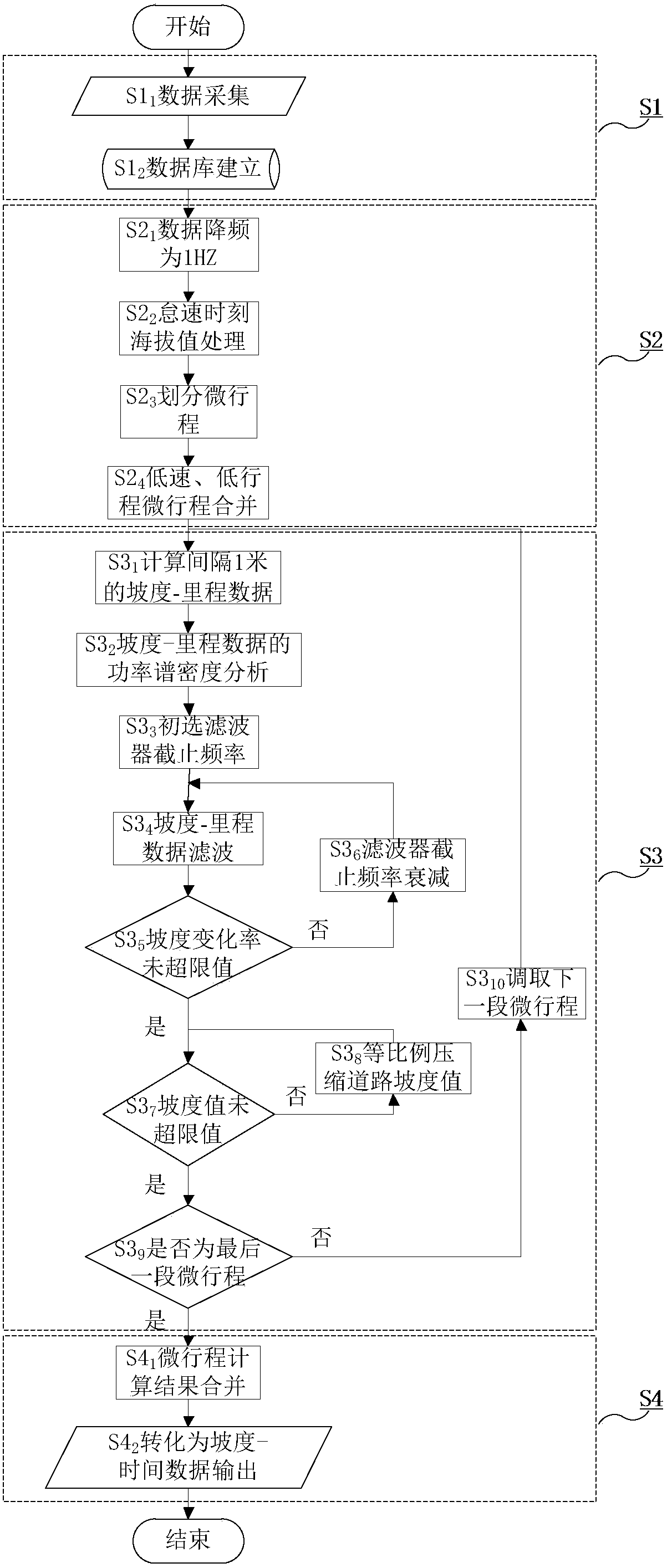
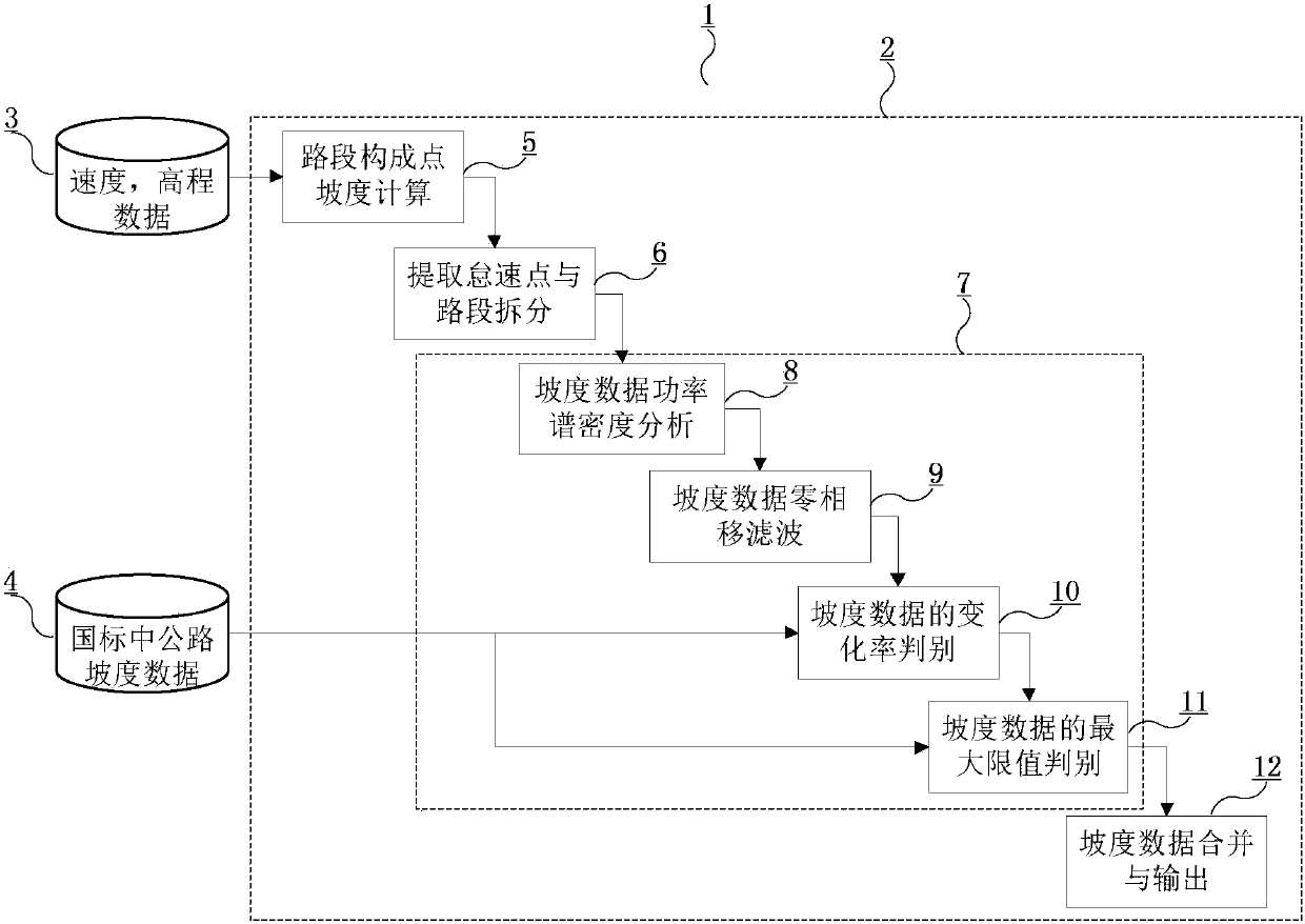
[0131] In order to solve the problem that the existing road slope calculation method based on GPS information is highly dependent on GPS signals, the calculation result has large errors, and cannot be used in the design of vehicle working conditions, thereby affecting the evaluation of vehicle power and economy, the present invention provides A road slope calculation method based on road alignment and frequency spectrum features, the method refers to figure 1 As shown, it includes the following four parts:

[0132] The first par...


PUM


Abstract

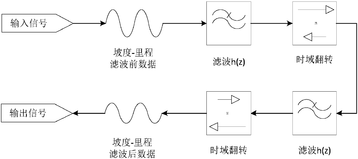
The invention relates to a road slope computation method based on road alignment and spectrum features and solves the problems that road slope information in existing automobile operation work condition design quite depends on GPS (global position system) signals, has large errors and cannot be applied to operation work condition design. The road slope computation method comprises the following steps: 1, acquisition of data and establishment of an original database Database; 2, data processing: data in the original database Database is underclocked, altitude values at idling moments are all set to be hidle, a traveling segment is divided into a plurality of micro-travels, and the micro-travels with a micro-travel distance smaller than a set limit value smin are combined in adjacent micro-travels; 3, computation of slope-mile i3-s3 in the micro-travels; 4, conversion of a slope-time i4-t4 sequence: slope-mile i3-s3 data computed in the step 3 in the micro-travels are combined, and the whole slope-mile i4-s4 data formed after combination is converted into slope-time i4-t4 data to be output according to mile-time s1-t1 data of a vehicle.

Description

technical field [0001] The invention relates to a road slope calculation method, in particular to a road slope calculation method based on road alignment and frequency spectrum features applied to working condition design. Background technique [0002] The fuel consumption and emissions of a vehicle are important indicators for evaluating a vehicle. When measuring the fuel consumption and emissions of a vehicle, the vehicle is usually run on an indoor drum test bench under standard operating conditions for a period of time, and the emissions of the vehicle during this period are measured. The above-mentioned standard working conditions include the speed and acceleration data of the vehicle running, and it is assumed that the road slope value is a fixed value of zero. However, when the vehicle is running under the condition that the actual road gradient changes, the standard zero gradient may not reflect the actual situation, and it may not be sufficient to accurately predic...

Claims


Application Information

Patent Timeline
Patent Type & Authority Patents(China)
IPC IPC(8): G01C9/00
CPCG01C9/00
Inventor 施树明马力岳柄剑张曼
Owner JILIN UNIV
Learn More