Matching method and device for traffic signs

A technology of traffic signs and matching methods, which is applied in the field of matching methods and devices of traffic signs, can solve the problems of low matching efficiency and manual matching efficiency, and achieve the effect of improving matching efficiency

Active Publication Date: 2019-03-08
BAIDU ONLINE NETWORK TECH (BEIJIBG) CO LTD
View PDF6 Cites 0 Cited by
  • Summary
  • Abstract
  • Description
  • Claims
  • Application Information

AI Technical Summary

Problems solved by technology

[0004] However, because each road section is composed of many single-frame point clouds, and for each single-frame point cloud, it is necessary to manually match the image and point cloud data, so only engineers are used to manually map images and point cloud data , the matching efficiency is low
As the number of frames of point cloud data frames increases, the defect of low manual matching efficiency will become more prominent

Method used


Image

  • Matching method and device for traffic signs
  • Matching method and device for traffic signs
  • Matching method and device for traffic signs

Examples


Embodiment 1

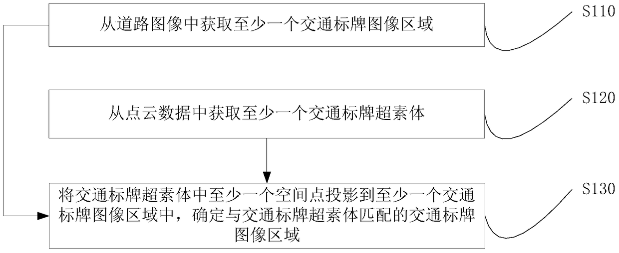
[0022] figure 1 It is a flow chart of the traffic sign matching method provided in Embodiment 1 of the present invention. This embodiment is applicable to the situation where road point cloud data and road images are matched. This method can be used to perform road point cloud data and road images The matching terminal can be executed, and the terminal can be a server, a personal computer, a notebook computer, a tablet computer, a car center console, a smart phone or a smart wearable device, etc. The method includes:

[0023] S110. Acquire at least one traffic sign image area from the road image.

[0024] The road image can be obtained by taking pictures of the road with a photographing device. The road image can be a color image or a grayscale image.

[0025] By performing image recognition on road images, the image area of ​​traffic signs is found from road images. When identifying, it can be searched according to the shape and color characteristics of the traffic sign. ...

Embodiment 2

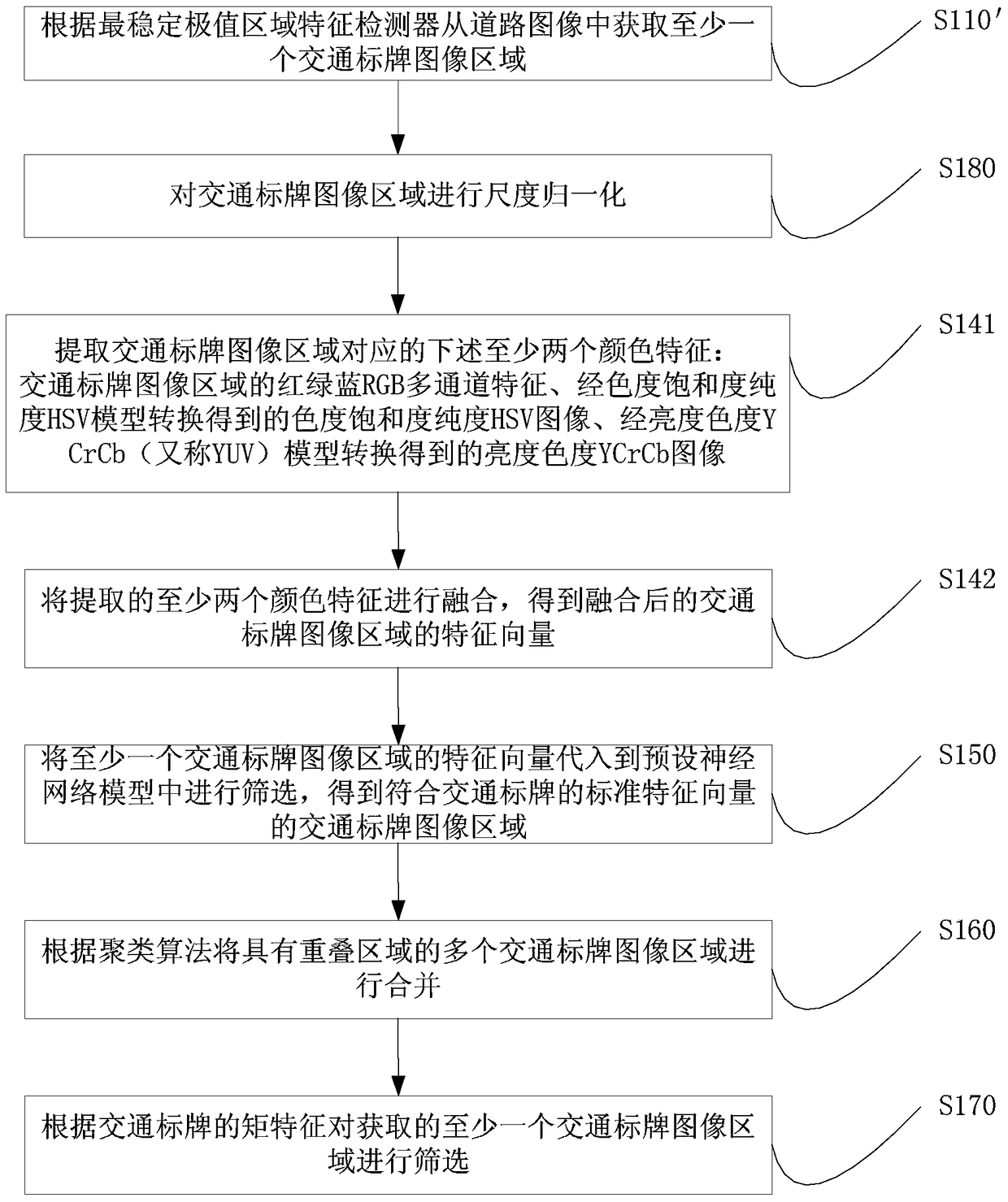
[0033] figure 2 It is a flow chart of the traffic sign matching method provided in Embodiment 2 of the present invention, wherein, S110, acquiring at least one traffic sign image area from the road image, can be implemented in the following manner:

[0034] S110'. Acquire at least one traffic sign image region from the road image according to the Most Stable Extremal Regions (Maximally Stable Extremal Regions, MSER) ​​feature detector.

[0035] The MSER feature detector is used to find the most stable regions in the image when the image is binarized using different grayscale thresholds. The MSER extraction process is as follows: first, use a series of gray thresholds to binarize the image; then, for the binary image obtained by each threshold, obtain the corresponding black area and white area; The area that maintains shape stability within the threshold range (such as 10-250) is extracted as the image area of ​​the traffic sign.

[0036] In actual use, traffic signs should...

Embodiment 3

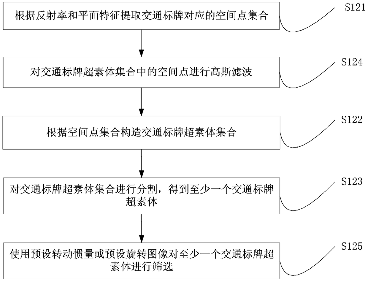
[0085] image 3 The flow chart of the traffic sign matching method provided by Embodiment 3 of the present invention, S120, obtaining at least one traffic sign super-body from the point cloud data, can be implemented in the following manner:

[0086] S121. Extract a set of spatial points corresponding to the traffic sign according to the reflectivity and plane features.

[0087] Spatial points have not only location information but also attribute information. Attribute information includes: directional features, color features, reflectivity, etc. of spatial points. A planar feature refers to a feature capable of forming a plane. Due to the shape characteristics of the traffic sign itself, its shape is a sheet. Therefore, it is necessary to find the set of spatial points forming a plane from the point cloud data. In addition, the physical traffic sign has certain radiation characteristics, so that it can provide the necessary instructions for drivers or pedestrians in the d...


PUM


Abstract

The invention discloses a matching method and device for traffic signs. The method includes: acquiring at least one traffic sign image area from a road image; acquiring at least one traffic sign super-pixel from point cloud data; projecting at least one spatial point in the traffic sign super-pixel to the at least one traffic sign image In the region, the image region of the traffic sign matching with the traffic sign superpixel is determined. The present invention can acquire at least one traffic sign image area from the road image by a machine, and then obtain at least one traffic sign superxel from the point cloud data; finally, project at least one space point in the traffic sign superxel onto the at least one In a traffic sign image area, determine the traffic sign image area matching the traffic sign superpixel. The invention uses a machine to match the area of ​​the traffic sign in the road image with the supervex of the traffic sign, thereby improving the matching efficiency.

Description

technical field [0001] The embodiment of the present invention relates to a point cloud data processing technology, in particular to a traffic sign matching method and device. Background technique [0002] The 3D high-precision map is recognized by the industry and academia as the main development direction of the next generation of digital maps. It is the prerequisite for the realization of automatic driving and assisted driving, and provides the main basis for accurate positioning and correct decision-making of autonomous vehicles. An important part of the 3D high-precision map is to establish the mapping relationship between the road image and the point cloud data of the traffic sign. The point cloud data of the traffic sign is the point data collection of the appearance surface of the traffic sign obtained by the measuring instrument in the reverse engineering. [0003] In the prior art, when establishing the mapping relationship between the road image and the point clou...

Claims


Application Information

Patent Timeline
Patent Type & Authority Patents(China)
IPC IPC(8): G06K9/62
CPCG06V10/757G06V2201/09
Inventor 姜雨何贝蒋昭炎宋良
Owner BAIDU ONLINE NETWORK TECH (BEIJIBG) CO LTD
Why Eureka
Try Eureka