Urban intersection automatic identification method based on low precision space-time trajectory data

A spatio-temporal trajectory, automatic identification technology, applied in the direction of road vehicle traffic control system, traffic flow detection, traffic control system, etc., can solve the problems of long cycle, low sampling frequency and high data acquisition cost

Active Publication Date: 2016-07-20
WUHAN UNIV
View PDF7 Cites 44 Cited by
  • Summary
  • Abstract
  • Description
  • Claims
  • Application Information

AI Technical Summary

Problems solved by technology

However, the above studies did not conduct an in-depth analysis and identification of the plane structure in the local area of ​​the intersection
At the same time, using the time-space trajectory data with high sampling rate and high positioning accuracy to obtain the location of urban intersections has the characteristics of reliable accuracy, but there are also problems caused by high data acquisition costs, long cycles, and inability to respond to changes in urban construction and lane functions. Limitations of Road Intersection Structural Changes
Compared with the space-time trajectory data with high sampling rate and high positioning accuracy, the low-precision space-time trajectory data from the urban taxi system or other acquisition equipment has low positioning accuracy and low sampling frequency, but its massive information contains rich road information
At present, it is difficult to obtain urban intersection structure information using low-precision spatio-temporal GPS trajectory data, and a large number of researches are still stuck in the extraction of road network maps, and the automatic identification of intersections is still in the research stage

Method used


Image

  • Urban intersection automatic identification method based on low precision space-time trajectory data
  • Urban intersection automatic identification method based on low precision space-time trajectory data
  • Urban intersection automatic identification method based on low precision space-time trajectory data

Examples


Embodiment Construction

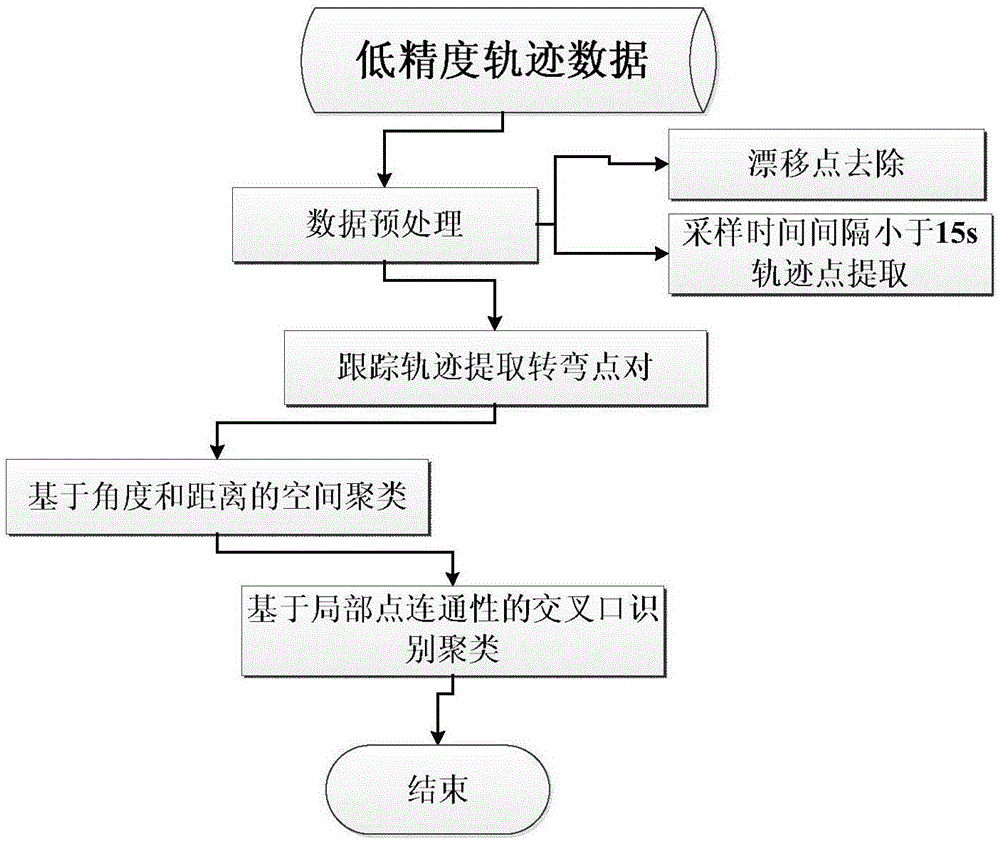
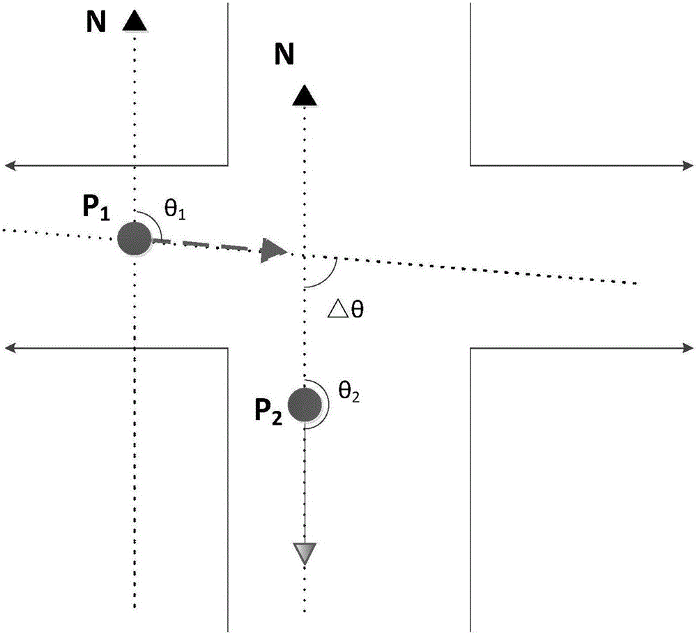
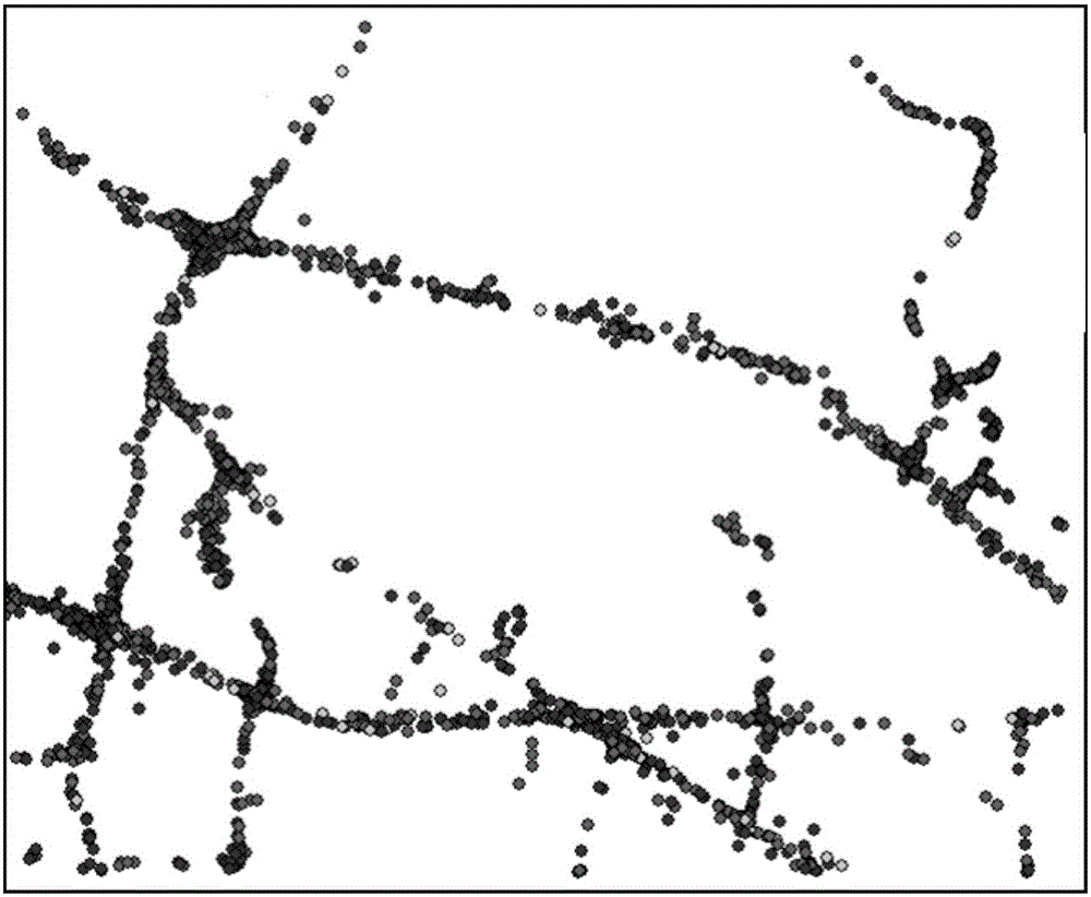
[0027] The invention designs a method for automatically identifying urban intersections based on low-precision spatio-temporal trajectory data, which reduces the cost of acquiring urban intersection structures, and the detection method is simple and easy to implement. The method provided by the present invention is as follows: firstly, use the density clustering method to eliminate the drift points in the original low-precision trajectory data, and then select the trajectory data whose sampling interval is less than 15s; secondly, track and identify the turning process of the trajectory, and extract a turning Turning point pairs whose heading angle change value exceeds the steering angle threshold and whose time interval is less than the time threshold in the process; then, use the distance and space-based growth clustering method to perform clustering calculations on all turning point pairs until each turning point pair Find its belonging category; further, calculate each turn...


PUM


Abstract

The invention provides an urban intersection automatic identification method based on low precision space-time trajectory data, which reduces the cost for obtaining urban intersection and provides basic data and a reference method for future auto-drive and intelligent traffic. The method comprises following steps: first, performing pretreatment to the data according to the spatial density and time interval of the trajectory data; secondly, tracking and identifying turning processes of the trajectory and extracting turning point pairs where the change of course angle exceeds a turning angle threshold value and the time interval is less than a time threshold value in one turning process; then, obtaining clusters and cluster centers of the turning point pairs by means of growing cluster method based on distance and space; finally, classifying the turning point pair clusters based on a cluster method of local point connection and completing intersection automatic identification through analyzing the turning property and the number of center points of the cluster center points. The intersection identification accuracy by means of the method is 94.3%.

Description

technical field [0001] The invention relates to a method for automatically identifying urban intersections based on low-precision spatio-temporal trajectory data, and belongs to the field of geographic information system and intelligent transportation research. Background technique [0002] Urban road intersection is an important part of the urban road system. It is the place where all kinds of traffic on the urban road meet, convert and pass, and is the control point for managing and organizing all kinds of traffic on the road. In the entire road network, the intersection becomes the checkpoint of traffic capacity and traffic safety, and plays a pivotal role in the application of intelligent traffic navigation. The current methods and data sources of urban intersection detection are mainly divided into two categories: identifying intersections from high-resolution remote sensing image data and extracting urban intersection locations from spatiotemporal trajectory data. Ext...

Claims


Application Information

Patent Timeline
Patent Type & Authority Applications(China)
IPC IPC(8): G08G1/01
CPCG08G1/0125G08G1/0137
Inventor 唐炉亮杨雪牛乐李清泉
Owner WUHAN UNIV
Why Eureka
Try Eureka