Nonlinear model-based multispectral remote sensing water depth inversion method and apparatus thereof

A nonlinear model and water depth inversion technology, which is applied to measuring devices, measuring the depth of open water sources, and water resource assessment, can solve problems such as errors, complex theoretical interpretation models, and low efficiency

Active Publication Date: 2016-08-17
CHINA TOPRS TECH
View PDF6 Cites 25 Cited by
  • Summary
  • Abstract
  • Description
  • Claims
  • Application Information

AI Technical Summary

Problems solved by technology

[0004] Because the remote sensing water depth inversion method of the theoretical interpretation model needs to calculate the water depth according to various optical parameters, and various optical parameters are difficult to measure directly, the numerical value will have a large error

Method used


Image

  • Nonlinear model-based multispectral remote sensing water depth inversion method and apparatus thereof
  • Nonlinear model-based multispectral remote sensing water depth inversion method and apparatus thereof
  • Nonlinear model-based multispectral remote sensing water depth inversion method and apparatus thereof

Examples


Embodiment 1

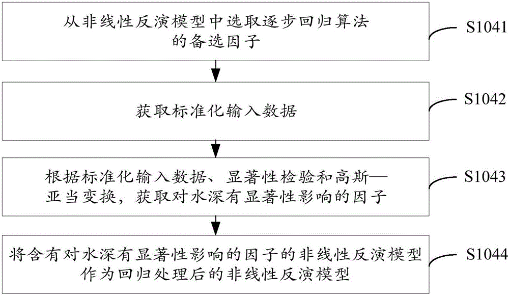
[0055] see Figure 1A , the embodiment of the present invention provides a nonlinear model-based multi-spectral remote sensing water depth inversion method, the method includes the following steps S101-S104.

[0056] Step S101: Obtain the multi-spectral remote sensing image of the preset area and the measured control point water depth value of the preset water area, and preprocess the multi-spectral remote sensing image to obtain the reflectance of the preset area.

[0057] In the embodiment of the present invention, the aforementioned preset water area is a water area in the aforementioned preset area, wherein the aforementioned preset area may be an area around islands and reefs far away from the mainland, and the aforementioned preset water area may be the area around islands and reefs far away from the mainland In the water area of ​​the island, reefs and reefs, some of the measured water depth points are selected as the actual measured water depth control points.

[0058]...

Embodiment 2

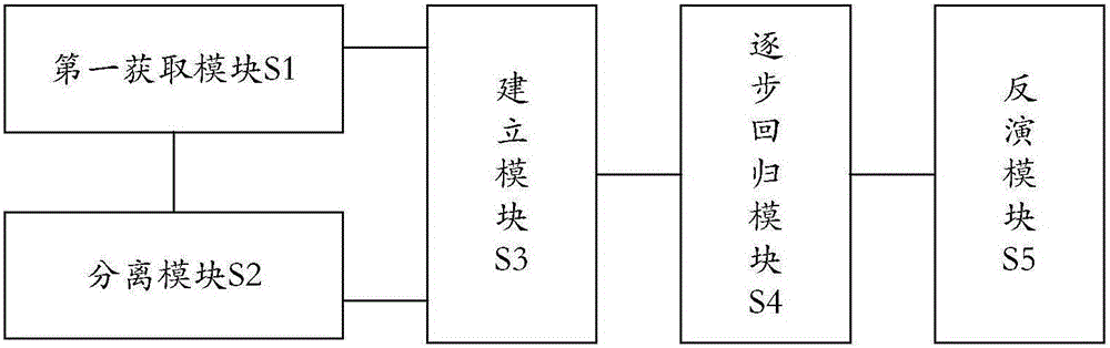
[0115] see figure 2 , the embodiment of the present invention provides a multi-spectral remote sensing water depth inversion device based on a nonlinear model, the device includes:

[0116] The first acquisition module S1 is used to acquire the multi-spectral remote sensing image of the preset area and the measured control point water depth value of the preset water area, and preprocess the multi-spectral remote sensing image to obtain the reflectance of the preset area;

[0117] The separation module S2 is used to separate water and land from the reflectance of the preset area based on the threshold method based on the spectral characteristics of the near-infrared band, and obtain the reflectance of the surface of the water body in the preset water area;

[0118] Establishing module S3, which is used to establish a nonlinear inversion model corresponding to the preset water area according to the reflectivity of the water body surface and the water depth value of the measured...


PUM


Abstract

The invention provides a nonlinear model-based multispectral remote sensing water depth inversion method and an apparatus thereof. The method comprises the following steps: acquiring the multispectral remote sensing image of a preset area and the actually measured control point water depth of a preset water area, and preprocessing the multispectral remote sensing image to obtain a preset area reflectivity; carrying out water-land separation on the preset area reflectivity through a near infrared waveband spectrum characteristic-based threshold technique to obtain the reflectivity of the water surface of the preset water area; establishing a nonlinear inversion model corresponding to the preset water area according to the water surface reflectivity and the actually measured control point water depth; and regressing the nonlinear inversion model through a stepwise regression algorithm, and inversing according to the regressed nonlinear inversion model to obtain the water depth of the preset water area. The highly-precise water depth of the island reef water area far from the land is rapidly obtained according to the nonlinear inversion model on the basis of the actually measured water depth, model establishing and the solving process are simple, and the nonlinear inversion model is suitable for various types of water depth inversion engineering and has good portability.

Description

technical field [0001] The invention relates to the technical field of satellite remote sensing applications, in particular to a nonlinear model-based multispectral remote sensing water depth inversion method and device. Background technique [0002] At present, with the wide application of satellite remote sensing technology, the improvement of bathymetry methods has been promoted, and the measurement of water depth by remote sensing bathymetry inversion has become an advanced bathymetry technology. [0003] Currently, water depth is measured by means of remote sensing water depth inversion, mainly through theoretical interpretation, based on the radiation transmission process of light in water and the atmosphere, and the water-leaving radiation model based on the radiation field distribution in the water body, and then obtained Quantitative model of sensor acquisition information and water depth value. [0004] Because the remote sensing water depth inversion method of th...

Claims


Application Information

Patent Timeline
IPC IPC(8): G01C13/00
CPCG01C13/008Y02A90/30
Inventor 李英成白洁薛艳丽范凤云彭硕
Owner CHINA TOPRS TECH
Why Eureka
Try Eureka