Remote sensing image segmentation method based on nonnegative low-rank sparse correlated drawing
What is AI technical title?
AI technical title is built by PatSnap AI team. It summarizes the technical point description of the patent document.
A remote sensing image and image segmentation technology, applied in the field of remote sensing image processing, can solve the problem of low precision of remote sensing image segmentation
Inactive Publication Date: 2016-10-12
HARBIN INST OF TECH
View PDF5 Cites 8 Cited by
Summary
Abstract
Description
Claims
Application Information
AI Technical Summary
This helps you quickly interpret patents by identifying the three key elements:
Problems solved by technology
Method used
Benefits of technology
Problems solved by technology
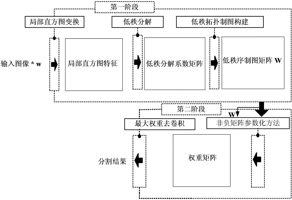
[0004] The purpose of the present invention is to solve the problem that the high homogeneity of texture information of high-resolution remote sensing images leads to low segmentation accuracy of remote sensing images, and to provide a remote sensing image segmentation method based on non-negative low-rank sparse correlation mapping
Method used
Image
Click on the blue label to locate the original text in one second.
Reading with bidirectional positioning of images and text.
Examples
specific Embodiment approach 1
[0014] Specific implementation mode one: the following combination figure 1 Describe this embodiment, the remote sensing image segmentation method based on non-negative low-rank sparse correlation mapping described in this embodiment, the specific process of the image segmentation method is:
[0015] Step 1. Quantify the remote sensing image: use the K-means clustering classification method to quantify the input image to be processed according to the gray scale range of the image, and remove redundant gray scale information;
[0016] The original image is f(x, y; v), (x, y) is the image coordinate, v∈[0,255] is the gray scale range of the image; the gray scale range k of the quantized image is set, and it is classified by the K-means clustering method After that, the quantized image is f(x,y;k);
[0017] Step 2. Extract the local histogram features of the image texture information: input the quantized image, and perform the systemconvolution operation Statize the local his...
specific Embodiment approach 2
[0022] Specific implementation mode two: this implementation mode further explains implementation mode one, and the specific process of performing quantitative processing on remote sensing images in step 1 is as follows:
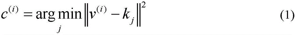
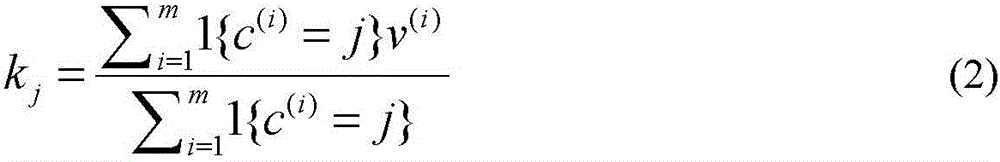
[0023] Step 1-1. Obtain the data closest to each initial quantized gray level:
[0024] c ( i ) = argmin j || v ( i ) - k j || 2 - - - ( 1 )
[0025] Among them, v is the gray value of the input image, i is the number of image pixels, k is the gray scale range of the image to ...
specific Embodiment approach 3
[0028] Specific implementation mode three: this implementation mode further explains implementation mode two, and the specific process of extracting the local histogram feature of image texture information in step 2 is as follows:
[0030] L w O σ { f n } n = 1 N - 1 ( x , v ) = Σ n = 0 N - 1 Σ x ′ ∈ X 1 ...
PUM
Abstract
The invention relates to a remote sensingimage segmentation method based on nonnegative low-rank sparse correlated drawing, belonging to the field of remote sensingimage processing. The invention aims to solve the problem of low accuracy of segmentation of remote sensing images due to high homogeneity of texture information in high resolution remote sensing images. The image segmentation method includes that the quantification processing of remote sensing images is carried out and the input image to be processed is quantized by the K-means clustering classification method according to the image gray level range; the local histogram characteristics of the image texture information are extracted; the local histogramcharacteristic matrix l1 / 2 norm constraint is subjected to low-rank decomposition; the low-rank sparse correlated drawing is constructed; the characteristic matrix is segmented based on the nonnegative matrix parameterization method of correlated drawing constraint, and for the weight matrix decomposed by the non-negative matrix parameterization method, the category maximum weight corresponding to the characteristic vector of each pixel is found in the weight matrix by a weighting-off convolution method to determine the classification category of the pixels is determined, and the image segmentation is realized. The remote sensing image segmentation method is used for remote sensing image segmentation.
Description
technical field [0001] The invention relates to a remote sensing image segmentation method based on texture information, which belongs to the field of remote sensing image processing. Background technique [0002] Remote sensing image segmentation has always been an important processing technology in remote sensing information target recognition, target extraction and other application fields. In the field of remote sensing information processing, texture information, as an important image feature, is widely used in the field of image segmentation. With the continuous improvement of the spatial resolution of satellite sensors, the rich texture information contained in the target area of remote sensing images can more finely characterize the complex shape, structure and surface image of the target. Aiming at the texture information of remote sensing images, the segmentation of high-resolution remote sensing images is realized through texture feature extraction combined wit...
Claims
Application Information
Patent Timeline
Application Date:The date an application was filed.
Publication Date:The date a patent or application was officially published.
First Publication Date:The earliest publication date of a patent with the same application number.
Issue Date:Publication date of the patent grant document.
PCT Entry Date:The Entry date of PCT National Phase.
Estimated Expiry Date:The statutory expiry date of a patent right according to the Patent Law, and it is the longest term of protection that the patent right can achieve without the termination of the patent right due to other reasons(Term extension factor has been taken into account ).
Invalid Date:Actual expiry date is based on effective date or publication date of legal transaction data of invalid patent.

