
Guidance display system for safety navigation of unmanned underwater vehicle

A technology of unmanned aerial vehicles and display systems, applied in the field of guidance and display systems, can solve problems such as inaccuracy, damage to aircraft, and task delays, etc., and achieve the effect of clear display interface, intuitive display content, and friendly man-machine interface

Active Publication Date: 2016-12-07
XIDIAN UNIV
View PDF5 Cites 5 Cited by
  • Summary
  • Abstract
  • Description
  • Claims
  • Application Information

AI Technical Summary

Problems solved by technology

Obviously, only relying on the seabed image and digital navigation parameters displayed by the traditional ground control station for navigation guidance cannot perform accurate and safe navigation and hovering on the bottom of the sea, and may even cause mission delays and even serious accidents such as aircraft damage and loss of contact.

Method used

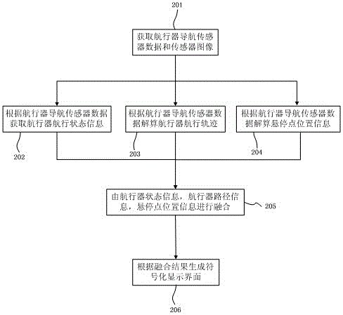
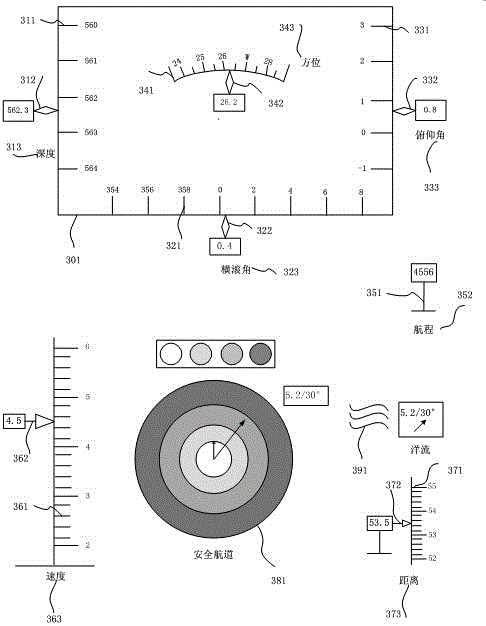

Image

  • Guidance display system for safety navigation of unmanned underwater vehicle
  • Guidance display system for safety navigation of unmanned underwater vehicle
  • Guidance display system for safety navigation of unmanned underwater vehicle

Examples


Embodiment Construction

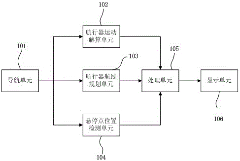
[0039] This example gives figure 1The shown guidance and display system for safe navigation of underwater unmanned vehicles includes at least: a navigation unit 101, a processing unit 105, a vehicle motion calculation unit 102, a vehicle safe course calculation unit 103, and a hovering point detection unit 104 and display unit 106 .

[0040] The navigation unit 101 is used to provide the navigation state information of the aircraft for the aircraft motion calculation unit 102; it is used to provide the course planning information for the aircraft safe course calculation unit 103; it is used to provide the hovering point for the hover position detection unit 104 location information;

[0041] The processing unit 105 is used to obtain the navigation status information from the aircraft motion calculation unit 102; to obtain the preset course from the aircraft safe course calculation unit 103, the actual course and the deviation information between the two; Acquiring the hover ...


PUM


Abstract

The invention relates to a guidance display system for safety navigation of an unmanned underwater vehicle. The system not only contains the navigation status information of the unmanned underwater vehicle, but also comprises the position information of safety navigation channels and hovering points, so that a water ground control station or ship operator can be assisted to sense the status of the unmanned underwater vehicle, so as to further complete safety navigation and hovering operation. In addition, the method adopts signifying mode, so that the display interface of the ground station is clearer and simpler, the displayed content is more directive and visualized, and man-machine interface is friendly. Through simple deformation, the guidance display system can be used for the safety navigation of the unmanned underwater vehicle.

Description

technical field [0001] The invention relates to a method for safe navigation of an underwater unmanned vehicle, in particular to a guidance and display system for safe navigation of an underwater unmanned vehicle. Background technique [0002] With the development of manned submarines and remote-controlled submarines, underwater unmanned vehicles have inherited and adopted many technologies related to manned submarines and remote-controlled submarines, and have been well developed. In recent years, underwater unmanned aerial vehicles have been widely used in mine reconnaissance, underwater attack, anti-submarine warfare, offshore oil development, underwater survey, and underwater target detection. [0003] However, the safe navigation of underwater unmanned vehicles and accurate fixed-point hovering on the seabed are a major problem currently facing, that is, how to safely navigate underwater unmanned vehicles to reach a preset fixed point on the seabed and hover. Especiall...

Claims


Application Information

Patent Timeline
Patent Type & Authority Applications(China)
IPC IPC(8): G01C21/16G01C21/00
Inventor 刘贵喜周杰李斯武治宇李建文
Owner XIDIAN UNIV
Learn More