Method and system for thematically displaying industrial map system projects on basis of data linkage

A data and thematic technology, applied in the field of thematic display of industrial map system projects, can solve the problems of staying in the macroscopic meaning and value of industrial maps, lack of good cases, etc., and achieve the effect of intuitive information interaction.

Inactive Publication Date: 2016-12-07
TAIHUA WISDOM IND GRP CO LTD
View PDF5 Cites 10 Cited by
  • Summary
  • Abstract
  • Description
  • Claims
  • Application Information

AI Technical Summary

Problems solved by technology

[0003] Current industrial information display methods: Relevant research stays in the macroscopic meaning and value of industrial maps, but there are no good cases in terms of specific display of industrial project information

Method used


Image

  • Method and system for thematically displaying industrial map system projects on basis of data linkage

Examples


Embodiment Construction

[0034] The present invention is described in detail below in conjunction with accompanying drawing:

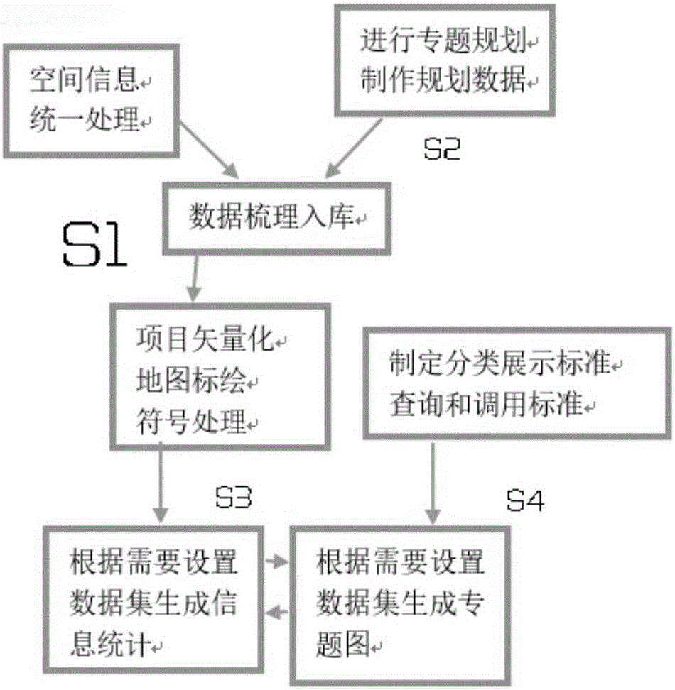
[0035] Such as figure 1 As shown, the data linkage-based industrial map system project special display method of this application includes the following steps:

[0036] Step 1: Unified processing of spatial information, the processing process is carried out under the unified GIS data platform to ensure the overall unity of the data; carry out thematic planning and production of planning data;

[0037] Step 2: sort out the processed spatial information and planning data into the database;

[0038] Step 3: Carry out vectorization processing on the stored data and plot the vectorized spatial data on the industrial map, and classify and use symbols to represent when plotting;

[0039] Step 4: Formulate classification display standards, query and call standards;

[0040] Step 5: Set the data set to generate information statistics. The setting of the data set is to obtain the int...


PUM


Abstract

The invention discloses a method and a system for thematically displaying industrial map system projects on the basis of data linkage. The method includes carrying out data combing and warehousing on spatial information processed in a unified manner and thematic planning and manufacturing planning data and storing the spatial information and the planning data in background servers; vectorizing and processing the warehoused data on GIS (geographic information system) platforms, plotting vectorized and processed spatial data on industrial maps, representing the spatial data in a classified manner by the aid of signs when the spatial data are plotted, converting the industrial spatial information into corresponding point, line and surface elements and displaying the point, line and surface elements on electronic maps; configuring data interaction between front-end assemblies and the background servers in B/S (browser/server) architectures and dynamically generating industrial information thematic maps. The method and the system have the advantages that flow data processing modes are established, accordingly, the data utilization rate can be increased, and the aggregation and inline degrees of the data can be improved.

Description

technical field [0001] The invention relates to the technical field of thematic display, in particular to a method and system for displaying a special topic of an industrial map system project based on data linkage. Background technique [0002] Although the industrial map is only a spatial expression from the perspective of regional economy, for the government and enterprises in different industries, the industrial layout, industrial policy, industrial spatial trend, industrial investment value, industrial competitiveness, industrial Information such as the upgrade and transfer process far exceeds the scope of a single map and drawing, and is of great significance to the government's macro-management, regional governance, corporate investment, corporate strategy, and corporate layout. [0003] Current industry information display methods: Relevant research stays in the macroscopic meaning and value of industrial maps, but there are no good cases in terms of specific display...

Claims


Application Information

Patent Timeline
Patent Type & Authority Applications(China)
IPC IPC(8): G06F17/30
CPCG06F16/248G06F16/258
Inventor 韦晓张同义董文泉马述杰王国松洛佳明陈美霞王小光王小鹏
Owner TAIHUA WISDOM IND GRP CO LTD
Why Eureka
Try Eureka