Data-driven transit-oriented development urban area division and mining method

A public transportation and urban area technology, applied in the field of TOD urban area division and mining based on urban data, can solve the problems that are not conducive to the development of urban public transportation and cannot well reflect the public transportation center.

Inactive Publication Date: 2016-12-07
DALIAN UNIV OF TECH
View PDF0 Cites 3 Cited by
  • Summary
  • Abstract
  • Description
  • Claims
  • Application Information

AI Technical Summary

Problems solved by technology

However, in the existing technology, regions are often divided directly according to latitude and longitude, or according to road network data, which cannot reflect the public transportation center well, and are not conducive to the development of cities around public transportation.

Method used


Image

  • Data-driven transit-oriented development urban area division and mining method
  • Data-driven transit-oriented development urban area division and mining method
  • Data-driven transit-oriented development urban area division and mining method

Examples


Embodiment Construction

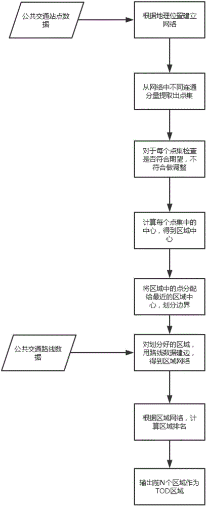
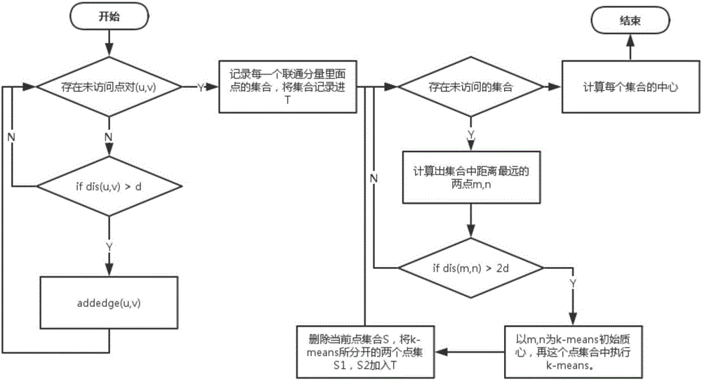
[0049] The embodiment of the present invention provides a data-driven public transportation-oriented urban area division and mining method, such as figure 1 As shown, the method includes:

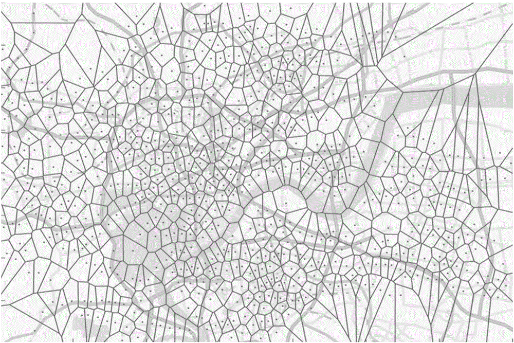
[0050] Step 1: Use the data of public transportation stations in Hangzhou to establish a public transportation network. The value of d is 800 here. For each point pair (u, v), if the distance (u, v) is less than d, add an edge edge(u, v), eventually forming a public transport network.

[0051] The public transportation lines and station data are as follows.

[0052] This paper studies three types of public transport stops and routes: regular bus, rapid transit, and subway. In the data set we obtained, it directly contains 8255 stops of 641 ordinary bus lines in Hangzhou in February 2015, and 446 stops of 14 BRT lines. The format is shown in Table 1.

[0053] Table 1 Data format of bus lines and stops

[0054] Tab.1Format of bus dataset

[0055]

[0056] Due to the lack of relevant inf...


PUM


Abstract

The invention discloses a data-driven transit-oriented development urban area division and mining method. The method includes the following steps that: the geographical positions of public transportation station sites are utilized to construct a network; different communication components in the network are extracted to establish point sets; each point set is detected, if the point sets do not satisfy requirements of expected point sets, the point sets are adjusted; the center points of the adjusted point sets are adopted as the centers of areas; points in the areas are allocated to the center of a nearest area; edges are established for the areas through using line data, so that an area network can be formed; the rankings of the areas are calculated according to the area network; and first N areas are outputted so as to be adopted as transit-oriented development (TOD) areas. According to the method of the invention, an urban area can be divided through using the data of the public transportation station sites, and the (TOD) areas are mined, and effective information can be provided for urban development. The method has the advantages of high feasibility, wide application range and accurate mining result.

Description

technical field [0001] The invention relates to the field of public transportation-oriented (TOD) urban development models, in particular to a TOD urban area division and mining method based on urban data. Background technique [0002] The TOD urban development model has become a possible solution to urban sustainable development. This development model can reshape the form of urban development, improve its quality, and alleviate many problems faced by the city. In order to construct a TOD city, the first problem is to divide the regions reasonably, and then select the most valuable regions as TOD regions for corresponding development. The present invention will use the public transportation station data to determine the area center and boundary method, and then use the public transportation route to mine the TOD area. However, in the existing technologies, regions are often divided directly according to latitude and longitude, or according to road network data, which canno...

Claims


Application Information

Patent Timeline
Patent Type & Authority Applications(China)
IPC IPC(8): G06Q10/04
CPCG06Q10/043
Inventor 孔祥杰余煊年夏锋宁兆龙杨秋源卢国旭
Owner DALIAN UNIV OF TECH
Why Eureka
Try Eureka