A method for identifying the driving direction of urban roads based on GPS information of floating cars
A technology of driving direction and information identification, which is applied in traffic control systems, instruments, and traffic flow detection of road vehicles, and can solve problems such as long engineering period, large amount of one-way urban roads, unfavorable electronic map making and updating, etc. , to achieve the effect of simple and direct calculation, saving manpower, material resources and time
- Summary
- Abstract
- Description
- Claims
- Application Information
AI Technical Summary
Problems solved by technology
Method used
Image

Examples
Embodiment 1
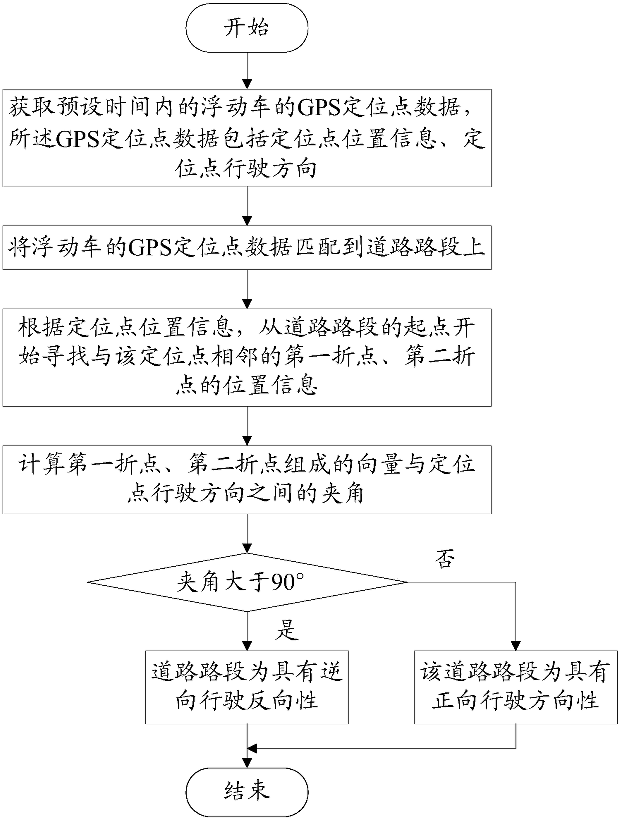
[0059] Please refer to figure 1 , The first embodiment of the present invention is:
[0060] A method for identifying the driving direction of a city road based on GPS information of a floating car, the method is:
[0061] Acquiring GPS positioning point data of the floating vehicle within a preset time, where the GPS positioning point data includes positioning point location information and positioning point driving direction;
[0062] Match the GPS location data of the floating car to the road section;
[0063] According to the location information of the positioning point, starting from the starting point of the road section to find the position information of the first and second turning points adjacent to the positioning point;
[0064] Calculate the angle between the vector composed of the first turning point and the second turning point and the driving direction of the positioning point, and judge the driving direction of the road section according to the value of the included an...
Embodiment 2
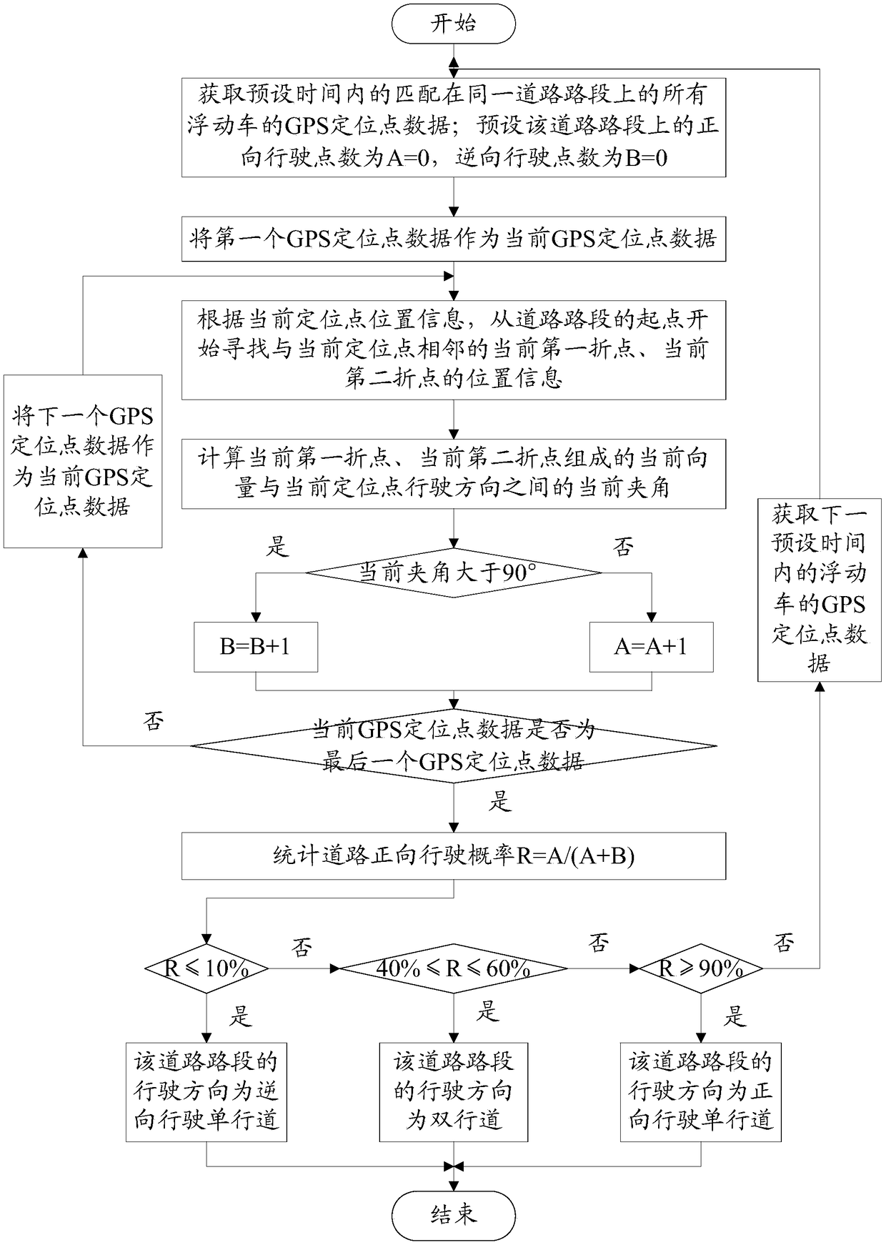
[0066] Please refer to figure 2 , The second embodiment of the present invention is:
[0067] A method for identifying the driving direction of a city road based on GPS information of a floating car, the method further comprising:
[0068] (1) Further judge the driving direction of the road section on the basis of Example 1:
[0069] S1 obtains the GPS positioning point data of all floating vehicles matching on the same road segment within a preset time; presets the number of forward driving points on the road segment as A=0, and the number of reverse driving points as B=0;
[0070] S2 uses the first GPS location data as the current GPS location data;
[0071] S3, according to the position information of the current positioning point, starting from the starting point of the road section to find the position information of the current first turning point and the current second turning point adjacent to the current positioning point;
[0072] S4 calculate the current angle between the cur...
Embodiment 3
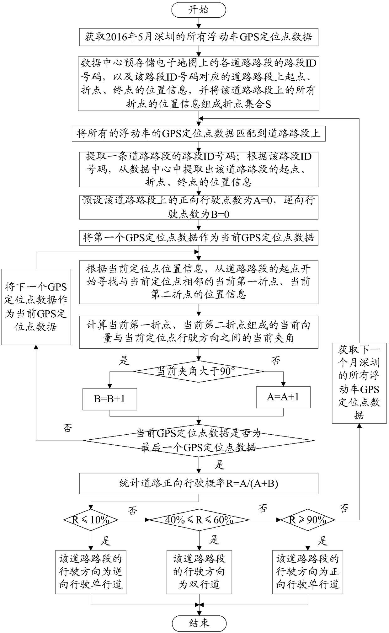
[0094] Please refer to image 3 , The third embodiment of the present invention is:
[0095] Assuming that the preset time is one month, taking the GPS positioning point data of the floating car in Shenzhen in May 2016 as an example, the method of the present invention for identifying the driving direction of urban roads based on the floating car GPS information is:
[0096] Obtain the GPS positioning point data of all floating vehicles in Shenzhen in May 2016, where the GPS positioning point data includes positioning point location information and positioning point driving direction;
[0097] The data center pre-stores the link ID number of each road section on the electronic map, and the location information of the starting point, turning point, and end point on the road section corresponding to the road section ID number, and composes the location information of all turning points on the road section Turn point set S;
[0098] Match the GPS location data of all floating vehicles to...
PUM
 Abstract
Description
Claims
Application Information
 - R&D
- Intellectual Property
- Life Sciences
- Materials
- Tech Scout
- Unparalleled Data Quality
- Higher Quality Content
- 60% Fewer Hallucinations
Browse by: Latest US Patents, China's latest patents, Technical Efficacy Thesaurus, Application Domain, Technology Topic, Popular Technical Reports.
© 2025 PatSnap. All rights reserved.Legal|Privacy policy|Modern Slavery Act Transparency Statement|Sitemap|About US| Contact US: help@patsnap.com