Vehicle accuracy positioning method based on inertial navigation and satellite differential positioning

An inertial positioning and differential positioning technology, applied in satellite radio beacon positioning systems, measuring devices, instruments, etc., can solve the problems that vehicles are difficult to obtain positioning information and the accumulation of position errors increases

Inactive Publication Date: 2017-01-11
付寅飞
View PDF6 Cites 51 Cited by
  • Summary
  • Abstract
  • Description
  • Claims
  • Application Information

AI Technical Summary

Problems solved by technology

[0006] Although satellite differential positioning can provide high-precision positioning services for vehicles, there is still a defect if relying solely on satellite differential positioning: since the system completely relies on satellite signals, it can only operate in open areas with good sate

Method used


Image

  • Vehicle accuracy positioning method based on inertial navigation and satellite differential positioning
  • Vehicle accuracy positioning method based on inertial navigation and satellite differential positioning
  • Vehicle accuracy positioning method based on inertial navigation and satellite differential positioning

Examples


Embodiment Construction

[0033] The technical solution of the present invention will be further described in detail below in conjunction with the embodiments. Apparently, the described embodiments are only some of the embodiments of the present invention, but not all of them. Based on the embodiments of the present invention, all other embodiments obtained by persons of ordinary skill in the art without creative efforts fall within the protection scope of the present invention.

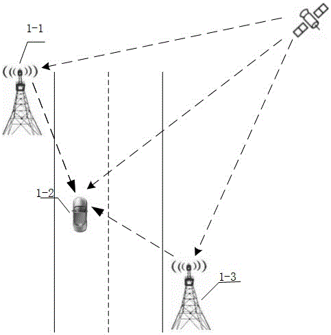
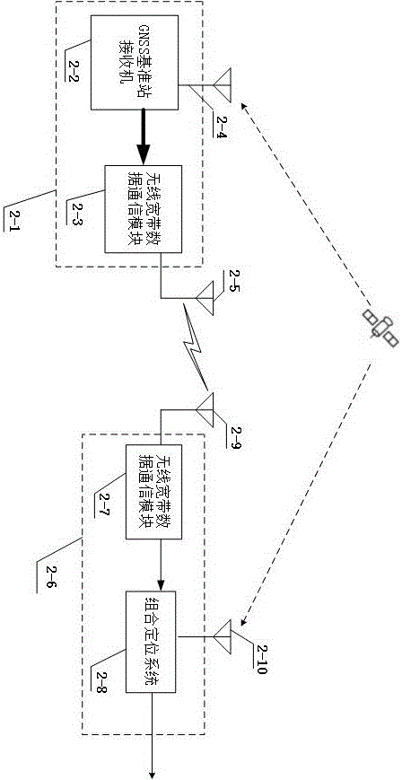
[0034] figure 1 For the system deployment and working diagram of this example, the base station 1-1 is a traditional base station of the 3G / 4G wireless communication system, or it may be a base station specially set up for this system. The base stations 1-1 are fixed and set up near the road. The distance between the base stations 1-1 can range from hundreds of meters to several kilometers. To ensure the positioning accuracy, it generally does not exceed 10 kilometers. The base station 1-1 receives GNSS satellite signals, a...


PUM


Abstract

The invention relates to the inertial-navigation-based technology and the satellite real time differential positioning technology. The vehicle accuracy positioning method of the invention utilizes wireless broadband data communication to provide accurate positioning to the vehicle. The vehicle accuracy positioning method combines the inertial navigation, the satellite real-time differential positioning technology and wireless broadband data communication together, provides a seamless positioning system applicable to intelligent transportation, provides real-time, stable and continuous position information from a sub-meter level to a centimeter level to a moving vehicle, and can realize a lane level positioning navigation. The technical scheme of the vehicle accuracy positioning method is that: the vehicle accuracy positioning method comprises a base station and a mobile terminal; a base station is installed near a road and consists of a base station satellite receiving machine and a wireless broadband communication module; and the mobile terminal is installed on the vehicle and consists of a wireless broadband communication module and a combination positioning system.

Description

technical field [0001] The invention relates to a precise positioning method which combines inertial navigation, satellite real-time difference technology and wireless broadband data communication, and continuously provides high-precision positioning services for vehicles. Background technique [0002] The intelligent transportation system applies advanced electronic information technology to transportation to realize efficient and value-added services, many of which are based on vehicle location information, so the positioning system is a basic platform in the intelligent transportation system. Intelligent transportation systems can use satellite positioning and navigation systems to provide location services for ground vehicles through space-based satellites. At present, the GNSS (satellite positioning and navigation) receiver installed on the vehicle can only rely on itself to receive satellite signals to complete single point positioning (SPP), and its position accuracy ...

Claims


Application Information

Patent Timeline
IPC IPC(8): G01S19/49
CPCG01S19/49
Inventor 付寅飞
Owner 付寅飞
Why Eureka
Try Eureka