Ground geomagnetic data intuitive color block processing method based on reference equivalent weight

A benchmark equivalent, magnetotelluric technology, applied in measurement devices, re-radiation of sound waves, and electrical/magnetic exploration, etc., can solve problems such as too large differences in geological conditions and very different interpretations by different people.

Inactive Publication Date: 2017-01-11
王玉喜
View PDF8 Cites 0 Cited by
  • Summary
  • Abstract
  • Description
  • Claims
  • Application Information

AI Technical Summary

Problems solved by technology

However, there are many ways to process the data collected in the field: curve display method, contour diagram method, measuring point graphic arrangement method, longitudinal section method and transverse section method, etc., but no mat

Method used


Image

  • Ground geomagnetic data intuitive color block processing method based on reference equivalent weight
  • Ground geomagnetic data intuitive color block processing method based on reference equivalent weight
  • Ground geomagnetic data intuitive color block processing method based on reference equivalent weight

Examples


Embodiment Construction

[0018] The method of the present invention will be further described in detail below in conjunction with the accompanying drawings of the embodiments.

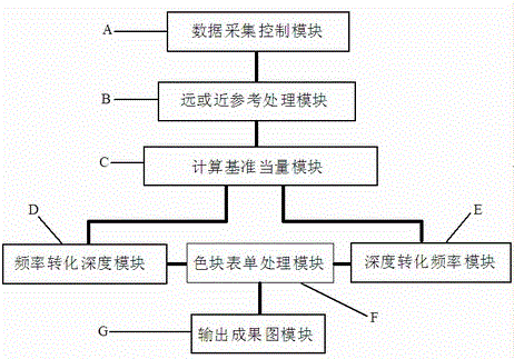
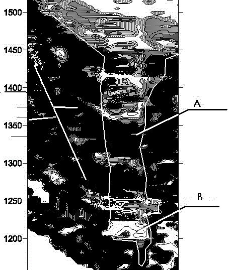
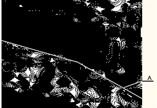
[0019] The purpose of the present invention is to process the data collected on site through the various steps described, and perform coloring processing according to the magnitude of geological information values ​​at different depths. The coloring method is to assign the same color code to the same value or close to the value, thereby generating a geological section picture. In this way, geologists can intuitively "see" fault structures, stratum dips, karst caves, and various ore body forms when they get the geophysical prospecting results map.

[0020] This embodiment is an implementation example of the present invention for exploring geological structures, a step of an intuitive color block processing method for magnetotelluric data based on benchmark equivalents, such as figure 1 Shown include.

[0021] Step 1) Place th...


PUM


Abstract

The present invention discloses a ground geomagnetic data intuitive color block processing method based on a reference equivalent weight. The method is applied in the technical field of ground geomagnetic bathymetry data processing. The method aims to overcome the defects in the existing ground geomagnetic bathymetry data inversion processing. The method can dynamically establish a reference equivalent weight to process the original data, and convert the data into different color blocks to visually display geological information including geological profile, fault structure, mineral location form or stratum information.

Description

[0001] An Intuitive Color Block Processing Method for Magnetotelluric Data Based on Datum Equivalent technical field [0002] The invention relates to the technical field of data processing of magnetotelluric sounding method, in particular to an intuitive color block processing method of magnetotelluric data based on reference equivalent. Background technique [0003] Magnetotelluric sounding is an important method of geophysical exploration. It is a very direct method for studying geology and has been widely used by many exploration workers. However, there are many ways to process the data collected in the field: curve display method, contour diagram method, measuring point graphic arrangement method, longitudinal section method and transverse section method, etc., but no matter which method is used for geological There are many problems in the inversion and interpretation of information, or the interpretation results of different people are far apart, which is too differ...

Claims


Application Information

Patent Timeline
IPC IPC(8): G01V3/38
CPCG01V3/38
Inventor 王玉喜冉宏振李重翟居静惠功领杨广军陈书楷
Owner 王玉喜
Why Eureka
Try Eureka