Spark platform supported spatial data management-based diagram calculation system and method

A technology of spatial data and graph computing, which is applied in the field of graph computing systems, can solve the problems of not supporting spatial data types and spatial operations, and SpatialGraphx does not take load imbalance and performance limitations into consideration, so as to achieve spatial range query and Spatial join operations, fast direct subgraph construction, and load-balancing effects

Active Publication Date: 2017-03-22
山东联友通信科技发展有限公司
View PDF5 Cites 25 Cited by
  • Summary
  • Abstract
  • Description
  • Claims
  • Application Information

AI Technical Summary

Problems solved by technology

[0003] However, after more in-depth research, we found that the SpatialGraphx framework has the following two important defects. It is these two defects that limit its performance when dealing with spatial graphs.
[0004] The first point: SpatialGraphx does not take into account the load imbalance caused by the different sizes of the graphs maintained by each slave node when executing spatial graph queries
This situation is due to the fact that in practice, the amount of spatial data generated in different regions is different due to differences in the economic level and traffic development of different regions, and SpatialGraphx partitions the overall data evenly according to the region (such as figure 1 ), the size of the data in each region is different, which causes the size of the graph maintained by each slave node to be dif

Method used


Image

  • Spark platform supported spatial data management-based diagram calculation system and method
  • Spark platform supported spatial data management-based diagram calculation system and method
  • Spark platform supported spatial data management-based diagram calculation system and method

Examples


Embodiment Construction

[0047] The present invention will be further described below in conjunction with the accompanying drawings and embodiments.

[0048] A graph computing framework that supports spatial data management based on the SpatialGraphx platform. In addition to the bottom data source, the framework includes three layers:

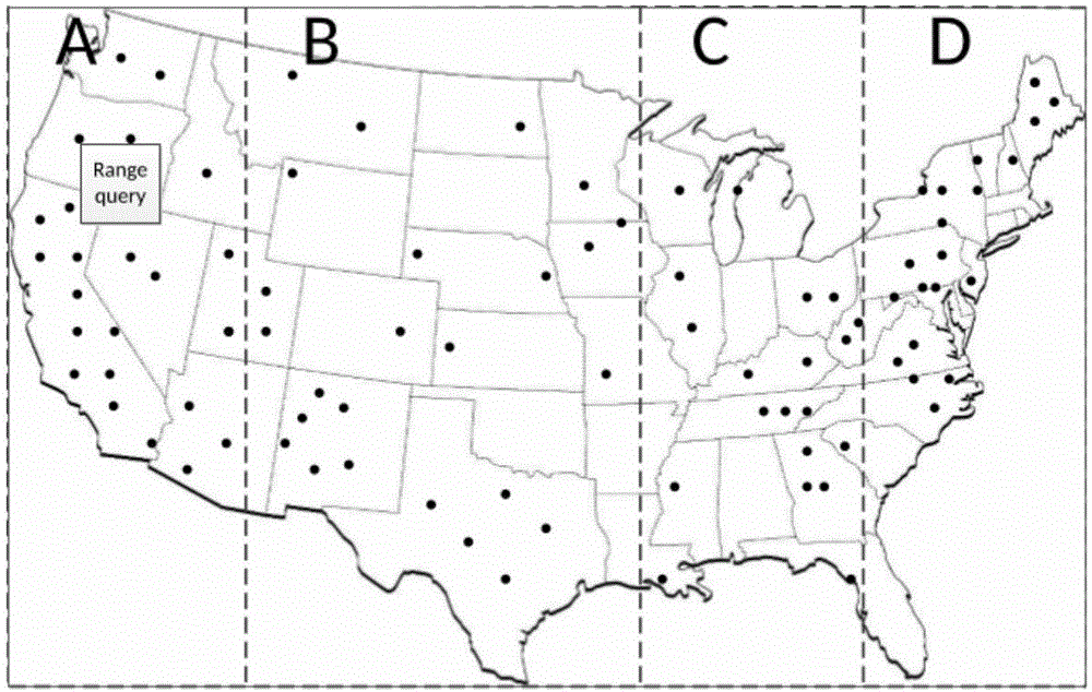
[0049] 1) The data management layer uses the ZCH (Z Curve Hashing) data partition method and establishes a QuadTree index for the underlying spatial data to provide a good spatial data management mechanism to achieve a responsible balance of data;

[0050] 2) The spatial operation layer is changed to increase the range query and spatial join operations of spatial data by extending SparkSQL's DataFrame;

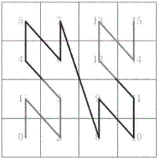
[0051] 3) In the graph computing layer, a position-based graph partitioning strategy is used to allocate the edges with closer distances to the same partition as much as possible, which realizes the construction of local graphs and the improvement of graph computing ef...


PUM


Abstract

The invention discloses a Spark platform supported spatial data management-based diagram calculation system and method. The method comprises the following steps of: dividing a spatial range of spatial data into a plurality of rectangle areas according to geographic position information through receiving the spatial data, distributing data in each rectangle to different subareas, dividing the subareas into grids, sorting the grids, carrying spatial mapping on the data, and establishing a quadtree index; receiving query request of a diagram, converting the query request into data query, and carrying out search in an index of a data storage layer in a range of the requested diagram; if a plurality of diagram data exists, carrying out spatial connection on multiple diagrams according to the returned query result, and distributing edges, in a set range, of distances in the query result into a same subarea on the basis of a diagram subarea strategy of positions so as to realize the construction of a local diagram. According to the system and method, direct spatial range query and spatial connection operation on the diagram are realized through extending the diagram query, and the requirements of numerous scenes are satisfied.

Description

technical field [0001] The invention relates to a graph computing system and method supporting spatial data management based on a Spark platform. Background technique [0002] With the popularization of information, a large amount of data containing location attributes will be generated every moment, and these data have gradually become an indispensable part of our digital life. Data that is attached to geographical location attributes like this is called spatial data, and there are many valuable data relationships hidden in these data, and graphs are the most intuitive and popular tools to show the relationships in the data. Therefore, more and more researchers have begun to pay attention to the research of graph computing and graph analysis of spatial data. Since there are many scenarios in real life, such as the investigation of the New York Big Bang, we only need to investigate the relevant data of a local area in a region. For the calculation and analysis of large-sca...

Claims


Application Information

Patent Timeline
IPC IPC(8): G06F17/30
CPCG06F16/29
Inventor 郭山清王昌圆韩艳祥张艮赵凯张学圣
Owner 山东联友通信科技发展有限公司
Why Eureka
Try Eureka