Path planning method and system based on urban traffic control signal lights

A path planning and urban traffic technology, applied in traffic control systems, traffic control systems of road vehicles, instruments, etc., can solve problems such as simple calculation conditions and inability to provide comprehensive considerations

Active Publication Date: 2017-03-22
CHANGSHA UNIVERSITY OF SCIENCE AND TECHNOLOGY
View PDF4 Cites 6 Cited by
  • Summary
  • Abstract
  • Description
  • Claims
  • Application Information

AI Technical Summary

Problems solved by technology

However, its calculation condition is too simple, it can only be one of the conditions such as driving distance or driving time, and cannot provide comprehensive results

Method used


Image

  • Path planning method and system based on urban traffic control signal lights
  • Path planning method and system based on urban traffic control signal lights
  • Path planning method and system based on urban traffic control signal lights

Examples


Embodiment 1

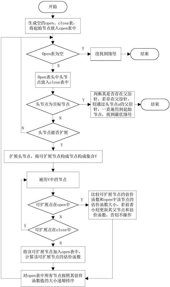
[0056] 1. First, obtain the urban road network data through GPS or an information server.

[0057] The urban road network data includes road names, node coordinates, whether there is a traffic control signal light at the node, and the average vehicle speed in the area. Node coordinates are represented by i(x,y), through which the Manhattan distance between two nodes is calculated.

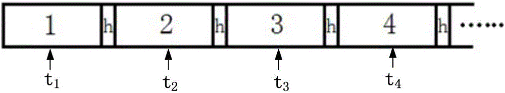
[0058] 2. If Figure 4 , where node 4 is the starting node, node 10 is the target node, when at node 4, the expandable nodes of node 4 are node 3 and node 5, then add node 3 and node 5 to the open table, and calculate two The evaluation function f(x) of the operator is sorted from small to large in the open table according to its value.

[0059] L s = L 4,5 +s'(N 5 )+L 5,6 +s'(N 6 )+L 6,7 +s'(N 7 )+L 7,12 +s'(N 12 )+L 11,12 +s'(N 11 )+L 10,11

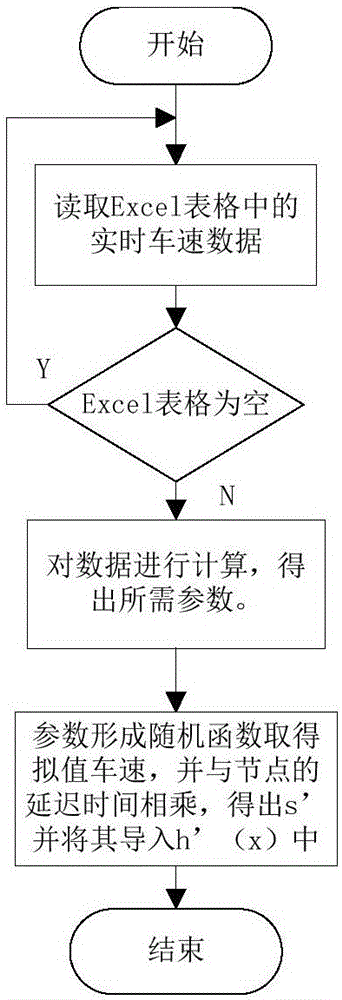
[0060] Calculation of the estimated function of the path: Assuming that all nodes are in the area, the vehicle speed in the area is updated e...


PUM


Abstract

The invention discloses a path planning method and system based on urban traffic control signal lights. The method comprises the following steps: step 1, taking all nodes in a road network as a node set, setting an initial starting point of a path as a current node; step 2, selecting adjacent nodes of the current node from the node set as next to-be-extended nodes of the path; step 3, calculating an evaluation function of all the to-be-extended nodes selected in step 2; and step 4, selecting the path to-be-extended node having minimum evaluation function value from all the to-be-extended nodes in step 3 to connect the current node, taking the selected to-be-extended node as a current node, and if the current node is a target node, ending path planning, otherwise, returning to step 2. The method combining delay caused by traffic control signal lights with the length of the path for calculating is more excellent than the path selection of algorithms only considering time and distance, and does not increase too much calculation difficulty.

Description

technical field [0001] The invention belongs to the field of path planning, in particular to a path planning method and system based on urban traffic control signal lights. Background technique [0002] The route planning in the urban road network refers to providing the driver with a relatively optimized route based on certain conditions according to the driver's travel plan on the urban roads. [0003] The path planning algorithm refers to the algorithm used by the computer to obtain the above path. Commonly used path planning algorithms include A star algorithm, Dijkstra algorithm, Floyd algorithm and heuristic search algorithm. [0004] Dijkstra algorithm: Dijkstra algorithm is the most classic shortest path search algorithm, and it is also a relatively time-consuming algorithm. It finds the shortest path according to the increasing order of weight value, which is concise and clear, and the results obtained by algorithm search are also relatively accurate. On the othe...

Claims


Application Information

Patent Timeline
Patent Type & Authority Applications(China)
IPC IPC(8): G08G1/0962G08G1/0968
Inventor 胡林杨佳黄晶杜荣华
Owner CHANGSHA UNIVERSITY OF SCIENCE AND TECHNOLOGY
Why Eureka
Try Eureka