Two-dimensional earthquake speed change space correction mapping method for high steep structure regions

A tectonic and regional technology, applied in the field of seismic data tectonic interpretation, can solve problems such as closure difference, and achieve the effect of improving work efficiency, efficient and fast automatic empty calibration, and improving effect

Active Publication Date: 2017-04-19
CHINA PETROLEUM & CHEM CORP +1
View PDF4 Cites 8 Cited by
  • Summary
  • Abstract
  • Description
  • Claims
  • Application Information

AI Technical Summary

Problems solved by technology

[0006] This disclosure proposes a two-dimensional seismic variable-velocity space calibration method for high-steep structural areas. For high-steep structural areas and only two-dimensional seismic survey lines, this

Method used


Image

  • Two-dimensional earthquake speed change space correction mapping method for high steep structure regions
  • Two-dimensional earthquake speed change space correction mapping method for high steep structure regions
  • Two-dimensional earthquake speed change space correction mapping method for high steep structure regions

Examples


Embodiment Construction

[0019] Preferred embodiments of the present disclosure will be described in more detail below with reference to the accompanying drawings. Although preferred embodiments of the present disclosure are shown in the drawings, it should be understood that the present disclosure may be embodied in various forms and should not be limited to the embodiments set forth herein. Rather, these embodiments are provided so that this disclosure will be thorough and complete, and will fully convey the scope of the disclosure to those skilled in the art.

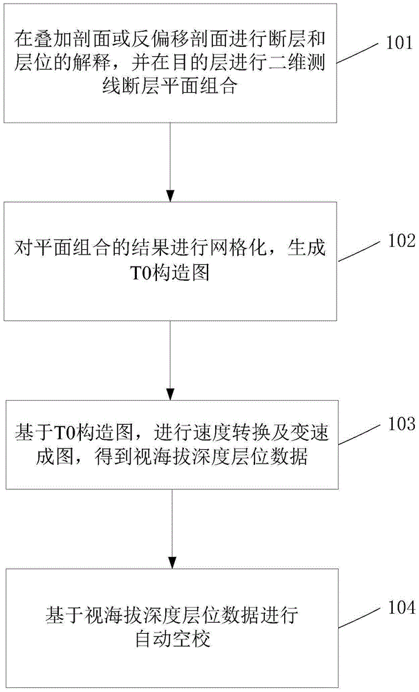
[0020] figure 1 It shows a flow chart of a two-dimensional seismic variable-velocity spatial calibration method for high-steep structural areas according to the present invention, and the method includes:

[0021] In step 101, interpretation of faults and horizons is performed on the stacked section or de-migration section, and combination of two-dimensional survey line fault planes is performed on the target layer.

[0022] In one example...


PUM


Abstract

The invention provides a two-dimensional earthquake speed change space correction mapping method for high steep structure regions. The method comprises steps that fault and horizon interpretation is carried out at a stacked section or a demigration section, and two-dimensional measuring line fault plane combination is carried out on a target layer; gridding of a plane combination result is carried out to generate a T0 structural map; on the basis of the T0 structural map, speed conversion and speed change mapping are carried out to acquire vision altitude depth horizon data. Automatic space correction is carried out on the basis of the vision altitude depth horizon data.

Description

technical field [0001] The invention belongs to the field of structural interpretation of seismic data, and in particular relates to a two-dimensional seismic variable-velocity space calibration method for high and steep structural areas. Background technique [0002] Variable speed mapping technology and empty calibration technology are important technologies involved in seismic data interpretation. [0003] One of the most important links in seismic data interpretation is velocity analysis and mapping. Accurate velocity extraction has always been a core issue in seismic exploration. In the process of traditional seismic data interpretation, constant-velocity mapping is generally used, that is, uniform velocity parameters are used to compile structural maps in the whole area, and velocity parameters are often obtained from a small amount of velocity spectrum or exploratory well data. This mapping method generally considers the velocity parameter constant of the same standa...

Claims


Application Information

Patent Timeline
IPC IPC(8): G01V1/28G01V1/36
Inventor 李洋陈勇张秀容章惠曹少蕾白帆
Owner CHINA PETROLEUM & CHEM CORP
Why Eureka
Try Eureka