Radar networking vertical line crossing integration positioning method and error calculating method thereof

A technology of cross fusion and positioning method, applied in the field of radar algorithm, which can solve the problems of poor positioning solution accuracy and cumbersome solution process.

Active Publication Date: 2017-05-10
中国人民解放军陆军军官学院
View PDF3 Cites 6 Cited by
  • Summary
  • Abstract
  • Description
  • Claims
  • Application Information

AI Technical Summary

Problems solved by technology

[0003] The purpose of the present invention is to provide a radar network vertical line intersection fusion positioning method and an error solution method to solve the problem of poor positioning

Method used


Image

  • Radar networking vertical line crossing integration positioning method and error calculating method thereof
  • Radar networking vertical line crossing integration positioning method and error calculating method thereof
  • Radar networking vertical line crossing integration positioning method and error calculating method thereof

Examples


Embodiment Construction

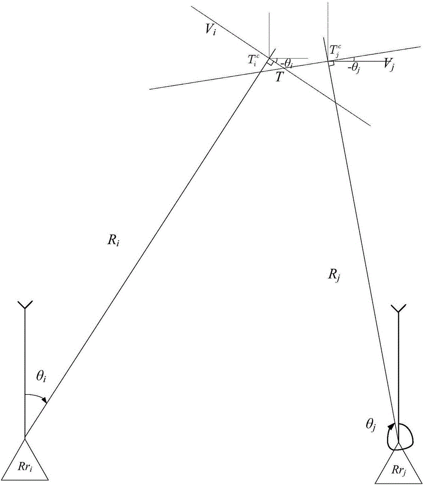
[0068] Such as figure 1 As shown, a radar network vertical cross fusion positioning method is characterized in that: two radars Rd i and Rd j The network is used to perform synchronous overlapping and simultaneous detection of the moving target T in the airspace, and the measured values ​​are [R i θ i beta i ] T and R j θ j beta j ] T , where R is the slant distance, θ is the azimuth angle, β is the elevation angle, and the configuration position of the network fusion center is [L B H] T , where L is the longitude, B is the latitude, H is the altitude, and the configuration positions of the radar centers of the two groups are [L i B i h i ] T , [L j B j h j ] T , and the center coordinates of the two radar fusion centers are respectively Among them, the coordinates of the center of the station are Cartesian coordinates of the northeast sky, the coordinate components are x, y, z, and the coordinates of the center of the fusion center of the target T ar...


PUM


Abstract

The invention discloses a radar networking vertical line crossing integration positioning method and an error calculating method thereof. The radar networking vertical line crossing integration positioning method comprises two parts: a vertical line crossing integration positioning method and an error calculating method of the vertical line crossing integration positioning method. The radar networking vertical line crossing integration positioning method and the error calculating method thereof are applied to a radar networking system to realize data fusion and intelligent decision-making assisting, so that the target positioning and tracking accuracy of the networking system can be improved, the error calibration accuracy of the networking system can be enhanced, and spatial distribution of detection accuracy of the networking system can be evaluated.

Description

technical field [0001] The invention relates to the field of radar algorithms, in particular to a radar network vertical line intersection fusion positioning method and an error resolution method. Background technique [0002] The radar network fusion positioning method, which is similar to the radar network vertical cross positioning technology, is mainly available for public inquiry. The article "Radar Network Triangle" published by Zhao Wenbo et al. Positioning Algorithm and Its Error Analysis", the article is based on the typical triangular space structure composed of two networked radars and the detected target, and uses the relationship between the corners of the triangle to locate and calculate the position of the target in the airspace. The disadvantage of this method is that the accuracy of target resolution is closely related to the angle formed by the two networked radars / targets. When the angle is in the range of 40 degrees to 120 degrees, the accuracy of positio...

Claims


Application Information

Patent Timeline
IPC IPC(8): G01S7/41
CPCG01S7/41
Inventor 赵温波王树坤张广政杨爱军丁海龙穆武第盛琥象雷史巍巍
Owner 中国人民解放军陆军军官学院
Why Eureka
Try Eureka