
Inter-satellite relative observation method used for satellite formation

A satellite formation and inter-satellite technology, applied in astronomical navigation and other directions, can solve the problems of radio wave space environment interference, difficulty in extracting feature points, and a large number of satellites, and achieve the effect of continuous tracking and observation.

Inactive Publication Date: 2017-06-20
SOUTHEAST UNIV
View PDF3 Cites 6 Cited by
  • Summary
  • Abstract
  • Description
  • Claims
  • Application Information

AI Technical Summary

Problems solved by technology

(2) In view of the absence of navigation signals for satellite formation missions in medium and high orbits, an inter-satellite radio navigation scheme is proposed; although its measurement accuracy is high, its working distance is far away, and its positioning time is short, radio waves are easily interfered by the space environment
(3) Visual measurement is produced with the development trend of deep space and autonomy of satellite formation flight missions. Due to its advantages of low cost and easy realization, it can solve the problem of determining relative pose parameters with high precision at short distances. It plays an important role, but due to the difficulty of feature point extraction and poor anti-occlusion ability, it is not suitable for the relative navigation of medium and long-range satellite formations
[0004] When multiple satellites fly in formation, the number of satellites is often large, and the single-satellite autonomous navigation method often ignores the relative motion information between the satellites during the formation flight.

Method used


Image

  • Inter-satellite relative observation method used for satellite formation
  • Inter-satellite relative observation method used for satellite formation
  • Inter-satellite relative observation method used for satellite formation

Examples


Embodiment Construction

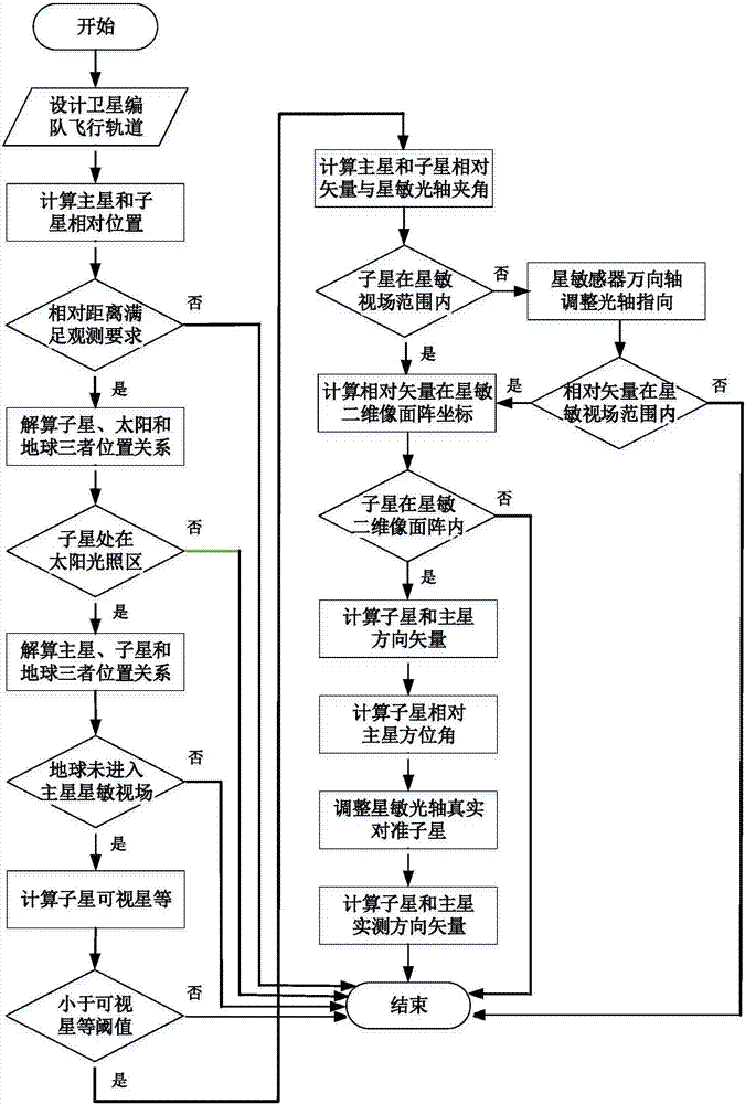
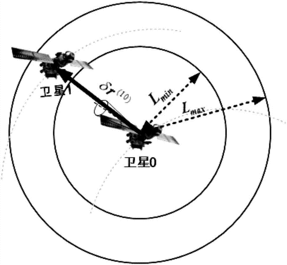
[0039] Aiming at the problem of relative observation between satellites during satellite formation flight, the present invention proposes to use star sensors for inter-satellite relative observation, that is, under the condition of satisfying the observation conditions of star sensors, the observed satellites use the observed satellites as the star sensors The relative azimuth measurement reference source, using the star sensor to measure the unit direction vector of the observed satellite relative to the observing satellite, and then combining the distance between the observed satellite and the observing satellite obtained by using the inter-satellite link measurement, calculate The direction vector of the observed satellite relative to the observing satellite is obtained.

[0040] Further, according to the preset task parameters of the satellite formation, it is judged whether the observation conditions of the star sensor are satisfied, and the observation conditions of the s...


PUM


Abstract

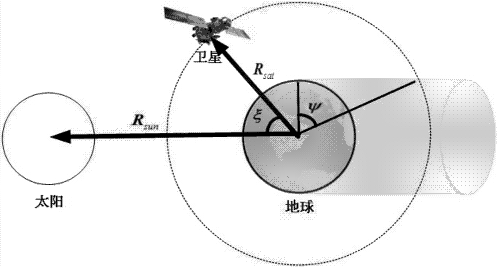
The invention discloses an inter-satellite relative observation method used for satellite formation, and belongs to the technical field of satellite formation flight space measuring. According to the inter-satellite relative observation method, a star sensor is arranged on an observation satellite; observation conditions of the star sensor are provided, an observed satellite is taken as the relative azimuth measurement reference source of the star sensor by the observation satellite, the star sensor is used for measuring the unit direction vectors of the observed satellite relative to the observation satellite, and the direction vectors of the observed satellite relative to the observation satellite are calculated based on the distance from the observed satellite to the observation satellite obtained via inter-satellite link measuring. The inter-satellite relative observation method is used for system analysis of illumination conditions and observation conditions needed by inter-satellite observation using the star sensor, and a series conditions used for guaranteeing observation quality and precision are provided. The inter-satellite relative observation method can be used for providing high precision relative observation information for satellite formation flying, and solving a problem that navigation precision is low because of lack of satellite formation flying observation information.

Description

technical field [0001] The invention relates to an inter-satellite relative observation method for satellite formation, and belongs to the technical field of satellite formation flight space measurement. Background technique [0002] A satellite formation is generally composed of a reference satellite (or master star) and several accompanying satellites (or slave stars). All satellites in the formation work together to complete space observation tasks that are difficult for a single satellite. Satellite formation flight navigation is one of the key technologies for studying formation flight. The quality of the navigation task depends on the accurate relative state information between satellites. configuration control. [0003] In recent years, with the changes in the accuracy and mission area of ​​satellite formation flight, scholars at home and abroad have conducted a lot of research on satellite formation flight inter-satellite relative measurement technology, mainly incl...

Claims


Application Information

Patent Timeline
IPC IPC(8): G01C21/02
CPCG01C21/02
Inventor 王鹏祝燕华张鸿翼
Owner SOUTHEAST UNIV
Learn More