Method and device for three-dimensional measurement and calculation of geographic position of target object based on street scene map
A technology of geographic location and target object, which is applied in the field of three-dimensional measurement and device for the geographic location of target objects based on street view maps, and can solve the problem that street view maps cannot obtain information such as actual geographic location and height.
- Summary
- Abstract
- Description
- Claims
- Application Information
AI Technical Summary
Problems solved by technology
Method used
Image

Examples
Embodiment 1
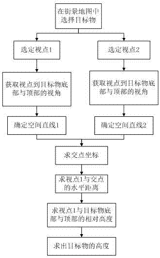
[0047] This embodiment takes Google's street view map as an example to further describe the technical solution of the method of the present invention. Such as figure 1 Shown, flow process of the present invention comprises the following steps:
[0048] Step 1: In the Google Street View map, for a target to be measured, select a suitable viewpoint that contains the target to be measured within two viewing angles;
[0049] Step 2: Obtain the latitude and longitude of the two viewpoints selected in the street view map;
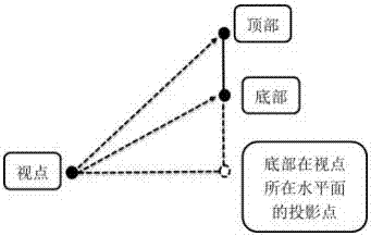
[0050] Step 3: Under each viewpoint, adjust the bottom and top of the target to the center of the street view map;
[0051] Step 4: Obtain the viewing angle parameters of the viewpoint in each state of the target in step 3, including the horizontal angle and pitch angle;
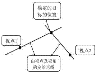
[0052] Step 5: According to the two viewpoints and the horizontal angle from the viewpoint to the bottom of the target, construct two spatial straight lines in the polar coordinate system; ...
Embodiment 2
[0110] This embodiment specifically illustrates the specific technical solution of the device of the present invention.
[0111] Such as figure 1 , a three-dimensional measurement and calculation device for the geographic location of a target based on a street view map, comprising:
[0112] The device is used for selecting the viewpoint of the target object to be measured within the range of two viewing angles in the street view map, including adjusting the viewing angle and field of view under the viewpoint after the two viewpoints are selected, and adjusting the target object to the street view Appropriate location of the map. Preferably, it is a device that adjusts the target object to a suitable position on the street view map by rotating the street view image; specifically, it is a device that adjusts the street view image by rotating so that the target object is clearly located within the field of vision as a whole without being blocked by obstacles.
[0113] A device ...
PUM
 Abstract
Description
Claims
Application Information
 - R&D
- Intellectual Property
- Life Sciences
- Materials
- Tech Scout
- Unparalleled Data Quality
- Higher Quality Content
- 60% Fewer Hallucinations
Browse by: Latest US Patents, China's latest patents, Technical Efficacy Thesaurus, Application Domain, Technology Topic, Popular Technical Reports.
© 2025 PatSnap. All rights reserved.Legal|Privacy policy|Modern Slavery Act Transparency Statement|Sitemap|About US| Contact US: help@patsnap.com