Three-dimensional police geographic information platform based on automatic analysis of commanding heights

A geographic information and automatic analysis technology, applied in geographic information databases, image data processing, data processing applications, etc., can solve the problem of limited urban virtual scenes, lack of internal space of buildings and the expression and connection of things in space, and the inability to truly express objectively World and other issues, to achieve the effects of saving time and human resources, facilitating inquiry and retrieval, and high auxiliary value

Active Publication Date: 2018-02-02
HANGZHOU MUNICIPAL PUBLIC SECURITY BUREAU SHANGCHENG DISTRICT BRANCH +1
View PDF5 Cites 0 Cited by
  • Summary
  • Abstract
  • Description
  • Claims
  • Application Information

AI Technical Summary

Problems solved by technology

However, with the development of 3D GIS so far, its application is still limited to the visual display and roaming browsing of urban virtual scenes.
The reason is due to the limitations of traditional digital city 3D modeling technology: traditional digital city 3D modeling mainly adopts the technical means of artificial modeling, sampling texture and sample map, and realizes the simulation of the objective world by means of simulation. Three-dimensional reproduction cannot truly simulate the objective world; however, various urban management departments such as public security, urban management, planning, and gardening need a "full information" urban model that can truly reflect the current status of the city
Although the above scheme improves the performance of the 3D geographic information system to a certain extent, its innovation lies in the improvement of the 3D geographic information system, and it still cannot fundamentally solve the technical problem of automatic analysis of the commanding heights mentioned above
In particular, 3D scenes still mainly use technical means such as artificial modeling, sampled texture, sampled texture, etc., and realize the 3D reproduction of the objective world by means of simulation, which cannot truly simulate the objective world. The traditional digital city construction model based on manual modeling The use of sampled city appearance simulation cannot truly represent the objective world. At the same time, it lacks the expression and connection of the interior space of the building and the things in the space. Based on the above model, the automatic analysis of the commanding heights cannot be realized.

Method used


Image

  • Three-dimensional police geographic information platform based on automatic analysis of commanding heights
  • Three-dimensional police geographic information platform based on automatic analysis of commanding heights
  • Three-dimensional police geographic information platform based on automatic analysis of commanding heights

Examples


Embodiment Construction

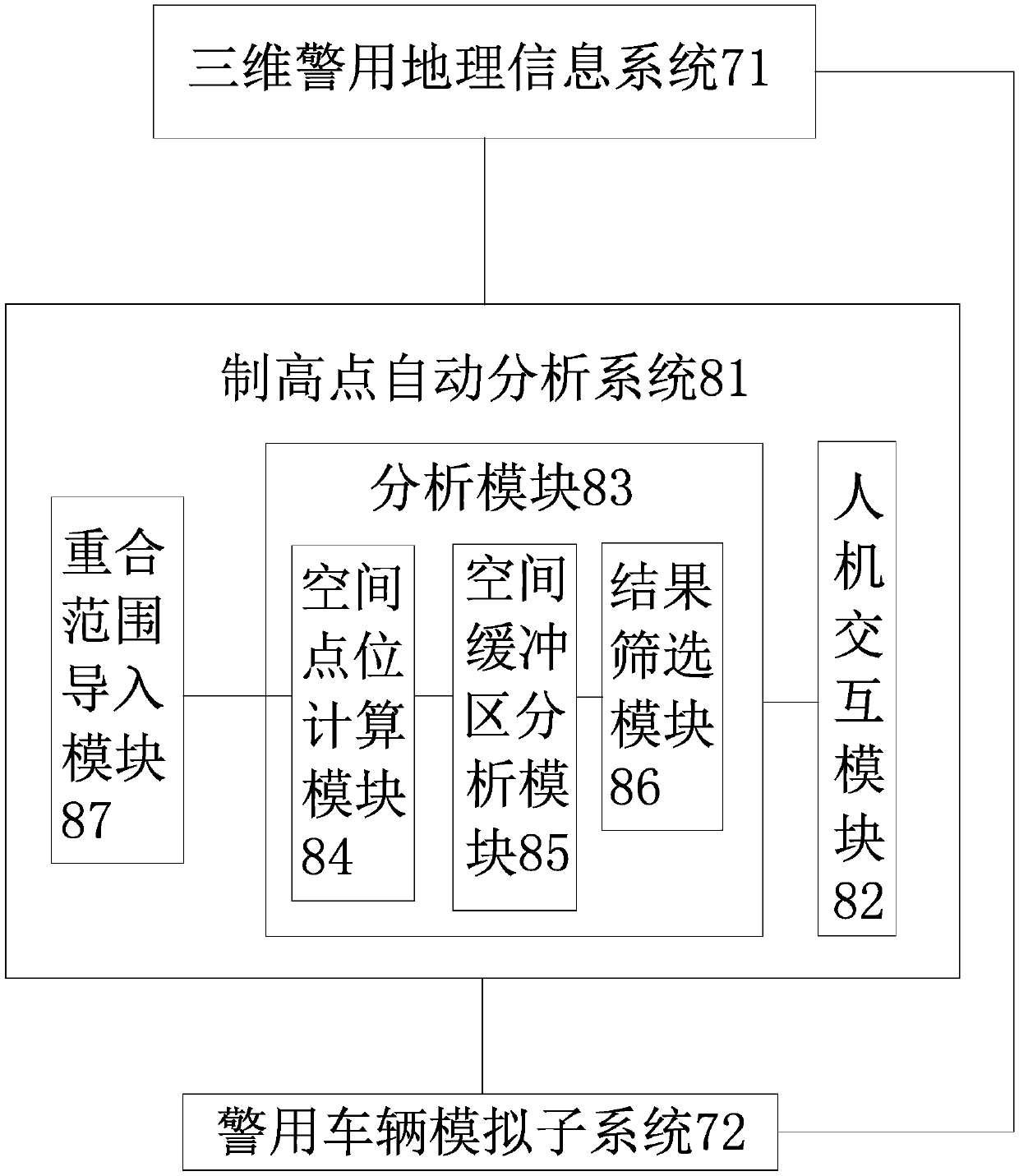
[0026] Such as figure 1 As shown, the three-dimensional police geographic information platform based on the automatic analysis of commanding heights includes a three-dimensional police geographic information system 71 and an automatic commanding height analysis system 81 connected to the three-dimensional police geographic information system 71, wherein the three-dimensional police geographic information system 71 is configured to integrate the real scene 3D model, selected building interior modeling data, plane geographic information and police information, and the commanding height automatic analysis system 81 is configured to realize the 3D police geographic information system 71 according to the input analysis object and range The commanding height analysis in; the commanding height automatic analysis system 81 comprises human-computer interaction module 82 and analysis module 83, and wherein human-computer interaction module 82 is configured to input analysis object and ra...


PUM


Abstract

The present invention relates to a three-dimensional police geographic information platform based on high point automatic analysis, which can solve the technical problems that the prior art cannot implement high point analysis and the like. The platform comprises a three-dimensional police geographic information system and a high point automatic analysis system connected with the three-dimensional police geographic information system. The three-dimensional police geographic information system is configured to integrate a real three-dimensional model, selected building interior modeling data, plane geographic information and police information; the high point automatic analysis system is configured to implement high point analysis according to the input analysis object and the range, and the high point automatic analysis system comprises a human-computer interaction module and an analysis module; and the analysis module comprises a spatial point location calculation module, a spatial buffer area analysis module and a result screening module that are successively connected. Advantages of the platform disclosed by the present invention are that: high point automatic analysis, consistent global positioning, ground and space integration, indoor and outdoor integration, interfaces and standards and other technical breakthroughs are realized, so that multi-level public security applications can be satisfied.

Description

technical field [0001] The invention belongs to the technical field of police information system construction and relates to a three-dimensional geographical information platform, in particular to a three-dimensional police geographic information platform based on automatic analysis of commanding heights. Background technique [0002] Commanding height analysis is a major problem in security work. In the security work of security guards, it has always been a difficult task to check the commanding heights around the guard site, the guard residence, and the guard line. The traditional work mode is carried out by the police to the scene to conduct on-the-spot surveys and check one by one. The police use the naked eye to observe and record manually. Due to the constraints of weather conditions and other factors, errors are prone to occur, and it is time-consuming and labor-intensive. At present, the application of two-dimensional police geographic information platform in vario...

Claims


Application Information

Patent Timeline
Patent Type & Authority Patents(China)
IPC IPC(8): G06F17/30G06Q50/26G06T17/00
CPCG06F16/29G06Q50/265G06T17/00
Inventor 秦文黄瑚唐恬郦兵张军民秦华王璐璐高畅畅郑庆辉胡兵勇陈梦琳牛健荣石芳芳
Owner HANGZHOU MUNICIPAL PUBLIC SECURITY BUREAU SHANGCHENG DISTRICT BRANCH
Why Eureka
Try Eureka