3D police geographic information platform and system architecture based on 3D spatial coding

A geographic information and three-dimensional space technology, applied in geographic information databases, closed-circuit television systems, image communications, etc., can solve problems that are difficult to achieve high efficiency and high accuracy, lack of expression and connection of building interior space and things in space, and cannot be real Express the objective world and other issues to achieve the effect of saving time and human resources, ensuring integrity and continuity, and high auxiliary value

Active Publication Date: 2017-12-15
张军民
View PDF2 Cites 0 Cited by
  • Summary
  • Abstract
  • Description
  • Claims
  • Application Information

AI Technical Summary

Problems solved by technology

[0004] Although the above scheme has improved the performance of the 3D GIS to a certain extent, its innovation is to improve the 3D GIS, and it still cannot fundamentally solve the technical problems mentioned above
In particular, it is still difficult to achieve efficient and high-accuracy encoding
In addition, 3D scenes still mainly use technical methods such as artificial modeling, sampled textures, and sampled maps. They realize the 3D reproduction of the objective world by means of simulation, which cannot truly simulate the objective world. The traditional digital city construction model based on manual modeling The use of sampled city appearance simulation cannot truly represent the objective world. At the same time, it lacks the expression and connection of the interior space of the building and the things in the space. Based on the above model, the automatic analysis of the commanding heights cannot be realized.

Method used


Image

  • 3D police geographic information platform and system architecture based on 3D spatial coding
  • 3D police geographic information platform and system architecture based on 3D spatial coding
  • 3D police geographic information platform and system architecture based on 3D spatial coding

Examples


Embodiment Construction

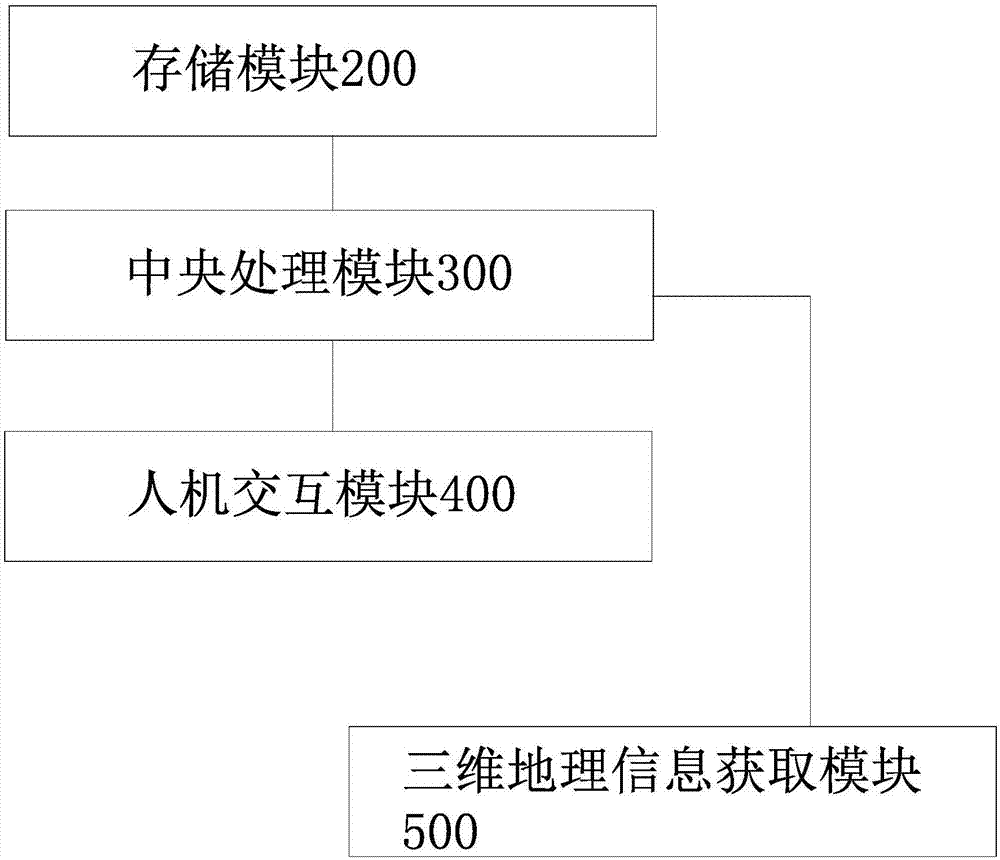
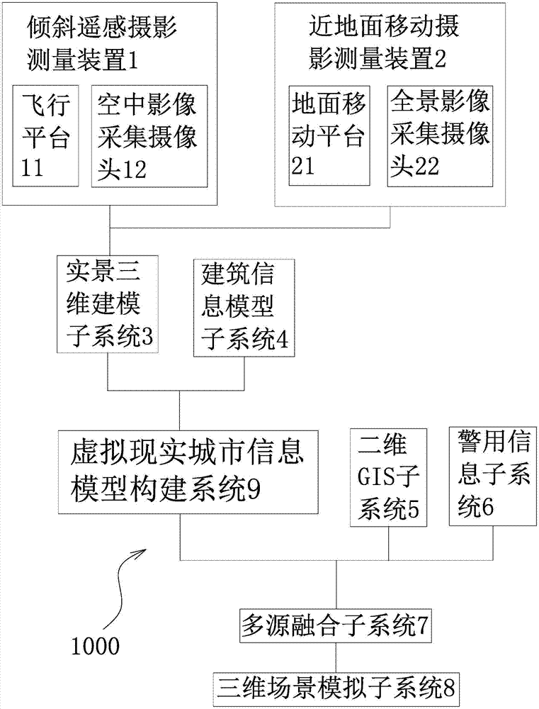
[0025] Such as figure 1 As shown, the system architecture of the three-dimensional police geographic information platform based on three-dimensional space coding includes a storage module 200 with at least one memory or several interconnected memories, a central processing unit with at least one central processor or several interconnected central processors Module 300, human-computer interaction module 400 and three-dimensional geographic information acquisition module 500, the storage module 200, human-computer interaction module 400 and three-dimensional geographic information acquisition module 500 are all connected to the central processing module 300, and the three-dimensional geographic information acquisition The module 500 includes a tilt remote sensing photogrammetry device 1 and a near-ground mobile photogrammetry device 2, and the tilt remote sensing photogrammetry device 1 and the near-ground mobile photogrammetry device 2 are respectively connected to the central p...


PUM


Abstract

The invention relates to a three-dimensional space encoding-based three-dimensional police geometric information platform and a system architecture, and solves the technical problems of low reasonability and the like of existing design. The three-dimensional police geometric information platform comprises a three-dimensional police geometric information system fusing a real scene three-dimensional model, selected building internal modeling data, planar geometric information and police information; and the three-dimensional police geometric information system directly establishes a logic graph layer of a three-dimensional space, performs division and encoding on the logic graph layer of the three-dimensional space, and takes the divided and encoded logic graph layer of the three-dimensional space as a place name address semantic mapping carrier for mapping a digital geometric space definition and an objective reality space. The three-dimensional police geometric information platform and the system architecture have the advantages that the logic graph layer of the three-dimensional space is directly established, the logic graph layer is divided and encoded, and the divided and encoded logic graph layer serves as the place name address semantic mapping carrier for mapping the digital geometric space definition and the objective reality space, so that the operation of binding with place name address record entries and geometric information entity elements is no longer carried out.

Description

technical field [0001] The invention belongs to the technical field of police information system construction and relates to a three-dimensional geographic information platform, in particular to a three-dimensional police geographic information platform and system architecture based on three-dimensional space coding. Background technique [0002] With the continuous development of GIS, its application field is continuously expanded, its scope is continuously expanded, and its technology is continuously upgraded. At the same time, more and more problems such as dealing with multi-source heterogeneous data and cross-platform operation need to be solved urgently in the development of GIS. Data acquisition and update is a major investment in establishing a GIS system, and reasonable classification and coding of data is an important basis for the establishment of the system in the future. From an application point of view, a successful GIS system largely depends on the synthesis...

Claims


Application Information

Patent Timeline
Patent Type & Authority Patents(China)
IPC IPC(8): G06F17/30G06Q50/26H04N7/18
CPCG06F16/29G06Q50/26H04N7/181
Inventor 张军民秦华
Owner 张军民
Why Eureka
Try Eureka