Three-dimensional police geographic information platform and system architecture

A geographic information, three-dimensional police technology, applied in the field of police information system construction, can solve the problems of inability to simulate the objective world, difficult to perfect and accurate, and limited urban virtual scenes.

Active Publication Date: 2018-04-13
张军民
View PDF7 Cites 0 Cited by
  • Summary
  • Abstract
  • Description
  • Claims
  • Application Information

AI Technical Summary

Problems solved by technology

However, with the development of 3D GIS so far, its application is still limited to the visual display and roaming browsing of urban virtual scenes.
The reason is due to the limitations of traditional digital city 3D modeling technology: traditional digital city 3D modeling mainly adopts the technical means of artificial modeling, sampling texture and sample map, and realizes the simulation of the objective world by means of simulation. Three-dimensional reproduction cannot truly simulate the objective world; however, various urban management departments such as public security, urban management, planning, and gardening need a "full information" urban model that can truly reflect the current status of the city
Geographical information coding technology has been widely used in the construction of geographic information systems, but they are all for two-dimensional space coding, and can only map known accurate ground objects.
Traditional coding must be accurate because it is bound to a specific point element geographic entity. However, in the actual operation, it is difficult to be perfect and accurate due to the real-time and accuracy of data collection and verification. For incomplete information data, it is difficult to unable to encode

Method used


Image

  • Three-dimensional police geographic information platform and system architecture
  • Three-dimensional police geographic information platform and system architecture
  • Three-dimensional police geographic information platform and system architecture

Examples


Embodiment Construction

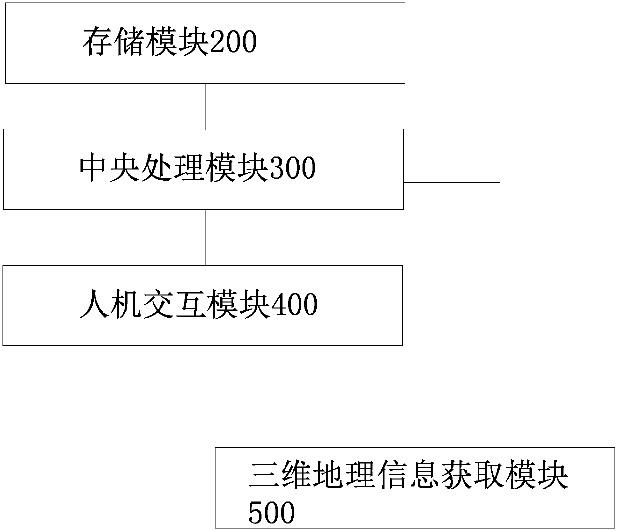
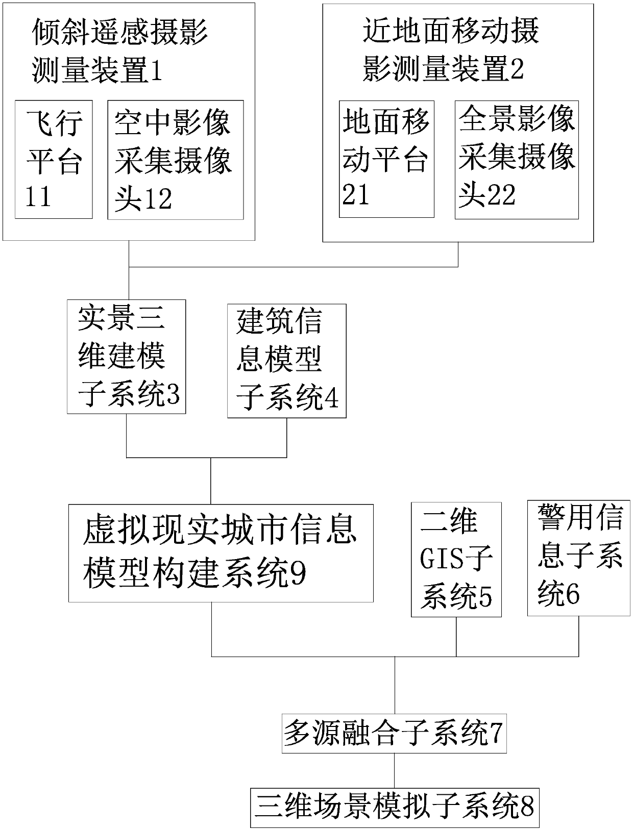
[0031] like figure 1 As shown, the three-dimensional police geographic information platform includes a storage module 200 with at least one memory or several interconnected memories, a central processing module 300 with at least one central processor or several interconnected central processors, and a human-computer interaction module 400 And the three-dimensional geographic information acquisition module 500, the storage module 200, the human-computer interaction module 400 and the three-dimensional geographic information acquisition module 500 are all connected to the central processing module 300, and the three-dimensional geographic information acquisition module 500 includes an oblique remote sensing photogrammetry device 1 and a near-ground mobile photogrammetry device 2, the tilt remote sensing photogrammetry device 1 and the near-ground mobile photogrammetry device 2 are respectively connected to the central processing module 300 through wireless communication. like ...


PUM


Abstract

The invention relates to a three-dimensional police geographic information platform and a system structure. The technical problem that in the prior art, design is not reasonable enough is solved. The three-dimensional police geographic information platform comprises a storage module, a central processing module, a human-computer interaction module and a three-dimensional geographic information acquisition module; the storage module, the human-computer interaction module and the three-dimensional geographic information acquisition module are all connected with the central processing module, and the three-dimensional geographic information acquisition module comprises an inclined remote sensing photogrammetry device and a near-surface mobile photogrammetry device which are connected with the central processing module in a wireless communication mode separately. The three-dimensional police geographic information platform has the advantages that technical breakthrough on uniform global positioning, air-ground integration, indoor-outdoor integration, interfaces, standards and the like is achieved, and therefore multi-layer public security application on security guard, counter terrorism, command and dispatch, bases and the like is achieved.

Description

technical field [0001] The invention belongs to the technical field of police information system construction, and relates to a three-dimensional geographic information platform, in particular to a three-dimensional police geographic information platform and system architecture. Background technique [0002] At present, the application of two-dimensional police geographic information platform in various public security departments has been relatively mature. Two-dimensional GIS basically realizes various functions related to police business, such as: GIS map display function, map operation function, police map function, GPS police car display function, map query and positioning function, drawing function, etc. Although to a certain extent, it meets the needs of the daily management work of the public security department, but the two-dimensional GIS maps the three-dimensional spatial information into two-dimensional plane information, which is inevitably too abstract in the e...

Claims


Application Information

Patent Timeline
Patent Type & Authority Patents(China)
IPC IPC(8): G06F17/30G06T17/05
CPCG06F16/29G06T17/05
Inventor 张军民秦华
Owner 张军民
Why Eureka
Try Eureka