Cloud step length estimation method

A step-length estimation and cloud-based technology, applied in the field of pedestrian dead reckoning, can solve the problems that the model cannot be adapted to everyone, the walking gait is different, and it is not suitable for everyone.

Active Publication Date: 2017-09-15
QIANXUN SPATIAL INTELLIGENCE INC
View PDF3 Cites 5 Cited by
  • Summary
  • Abstract
  • Description
  • Claims
  • Application Information

AI Technical Summary

Problems solved by technology

[0003] The existing technology is to use the pedestrian's stride frequency to estimate a unified step length model, but this method is not suitable for everyone.

Method used


Image

  • Cloud step length estimation method
  • Cloud step length estimation method
  • Cloud step length estimation method

Examples


Embodiment Construction

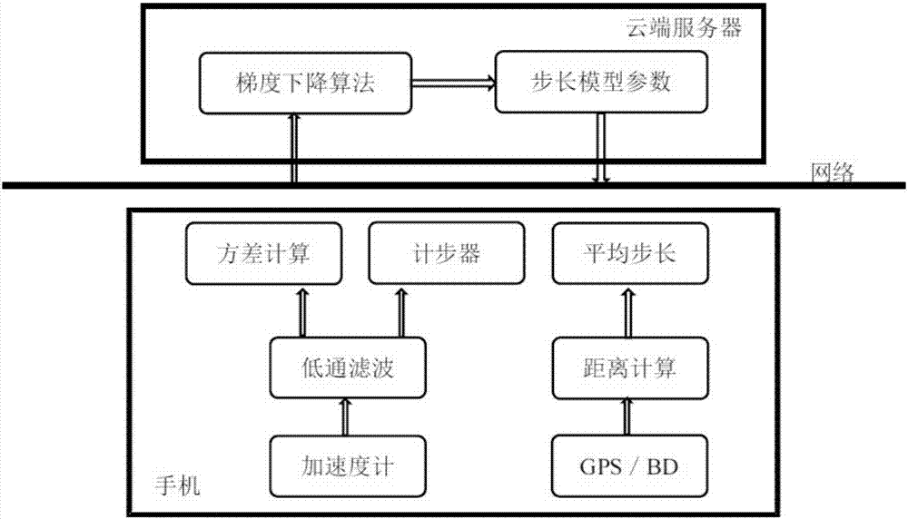
[0033] Hereinafter, the present invention will be further described in conjunction with the drawings and embodiments. Such as figure 1 As shown, the present invention sends the feature data step frequency, accelerometer variance and average step size collected by the mobile phone through low-pass filtering to the cloud server through the network, and the step size model is estimated by the gradient descent algorithm in the cloud server, and then the step size model The parameters are sent to the mobile phone to realize the integration of the cloud server. The specific steps are as follows:

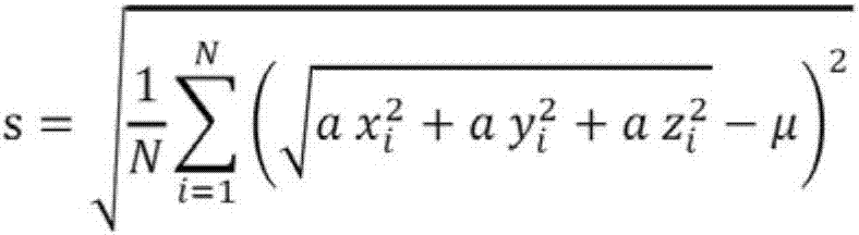
[0034] In step S1, the accelerometer of the mobile phone is used to measure the acceleration. When the user is walking or running, regular signals are generated with the swing of the human body or arms. The time interval between each step can be calculated through the traditional pedometer principle, that is, the step frequency; the standard deviation s and the variance of the accelerome...


PUM


Abstract

The invention provides a cloud step length estimation method which is characterized by comprising the following steps: S1, firstly, measuring acceleration by using an accelerometer of a mobile phone, calculating a time interval, that is, a step frequency, of every two steps according to pedometer principles, and calculating an accelerometer standard difference and an accelerometer square deviation within one second; S2, calculating the distance between two points according to positioning positions of a satellite navigation system; S3, calculating step numbers detected within any two time intervals according to the pedometer principles, and calculating an average step length within two time intervals; S4, transmitting the step frequency, the accelerometer square deviation and the average step length to a cloud server by the mobile phone through a network, calculating a step length model by the cloud server, and transmitting parameters of the step length model to the mobile phone. The invention aims to calculate step length estimation models applicable to different people, and the precision error of step length estimation is less than 5% ultimately.

Description

technical field [0001] The present invention relates to the field of dead reckoning for pedestrians, in particular to a method for estimating step length in the cloud. Background technique [0002] PDR (Pedestrian Dead Reckoning, Pedestrian Dead Reckoning) is a positioning technology for pedestrian dead reckoning. Calculate the next positioning position according to the distance of each step and the walking direction of a person, which is very suitable for continuing positioning in an environment where satellite signals are interrupted (such as shopping malls, hospitals), and improving the efficiency of positioning. This technology mainly uses the built-in MEMS sensors (three-axis gyroscope, three-axis accelerometer and three-axis magnetic sensor) of mobile phones to estimate the direction of pedestrians and the length of each step of pedestrians through sensor data fusion, which can realize indoor positioning. Since each person's height and weight are different, it is impo...

Claims


Application Information

Patent Timeline
IPC IPC(8): G01C21/16G01C21/20
CPCG01C21/165G01C21/206
Inventor 邵刘军
Owner QIANXUN SPATIAL INTELLIGENCE INC
Why Eureka
Try Eureka