Method and system for acquiring high-precision submarine topographic and geomorphologic map

A technology of terrain and landform and acquisition method, which is applied in the field of acquisition of high-precision seabed topography and landform map, and can solve problems such as the influence of navigation accuracy

Active Publication Date: 2017-09-29
NAT DEEP SEA CENT
View PDF5 Cites 17 Cited by
  • Summary
  • Abstract
  • Description
  • Claims
  • Application Information

AI Technical Summary

Problems solved by technology

However, the submersible's attitude, starboard and starboard positions, and navigation accura

Method used


Image

  • Method and system for acquiring high-precision submarine topographic and geomorphologic map
  • Method and system for acquiring high-precision submarine topographic and geomorphologic map
  • Method and system for acquiring high-precision submarine topographic and geomorphologic map

Examples


Embodiment Construction

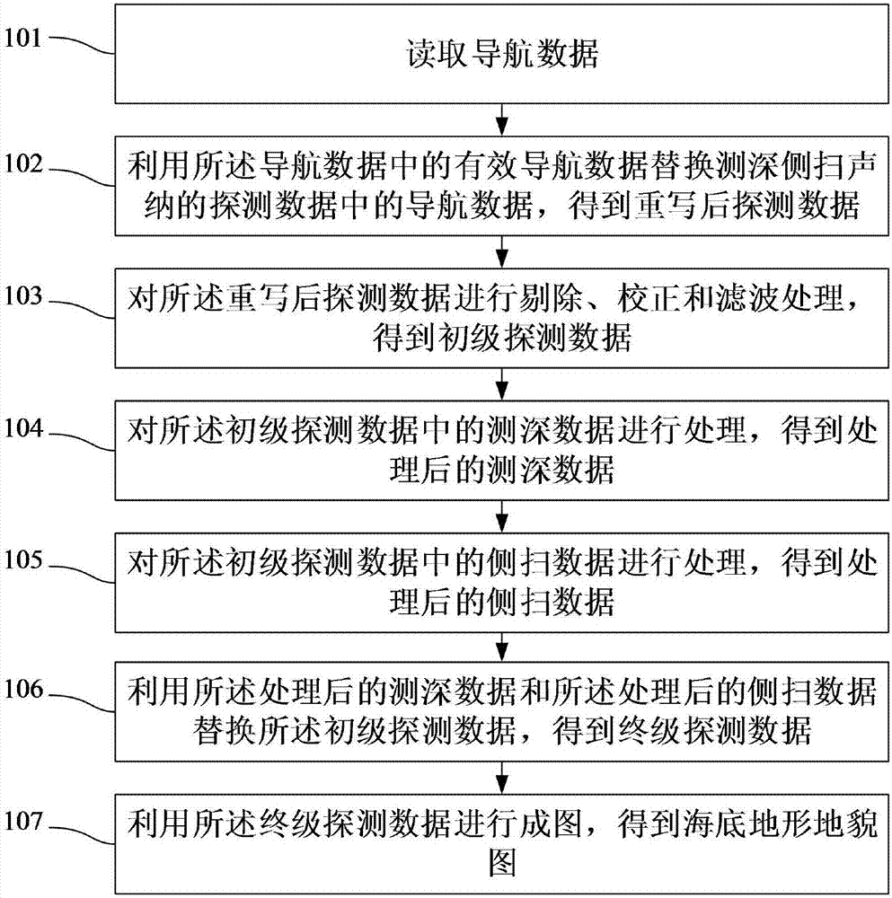
[0082] The following will clearly and completely describe the technical solutions in the embodiments of the present invention with reference to the accompanying drawings in the embodiments of the present invention. Obviously, the described embodiments are only some, not all, embodiments of the present invention. Based on the embodiments of the present invention, all other embodiments obtained by persons of ordinary skill in the art without making creative efforts belong to the protection scope of the present invention.

[0083] The object of the present invention is to provide a method and system for obtaining a high-precision seabed topography map, so that the seabed topography map obtained by the acquisition method and system is closer to the real seabed topography, the image accuracy is higher, and the map is formed Faster.

[0084] In order to make the above objects, features and advantages of the present invention more comprehensible, the present invention will be further...


PUM


Abstract

The invention discloses a method and device for acquiring a high-precision submarine topographic and geomorphologic map. The method comprises the steps of acquiring navigation data, replacing navigation data in detection data of bathymetric sidescan sonar by using effective navigation data in the navigation data, acquiring rewritten detection data, and performing rejection, correction and filtering processing on the written detection data to acquire primary detection data; processing bathymetric data in the primary detection data to acquire processed bathymetric data; processing sidescan data in the primary detection data to acquire processed sidescan data; replacing the primary detection data by using the processed bathymetric data and the processed sidescan data to acquire final detection data; and mapping by using the final detection data to acquire a submarine topographic and geomorphologic map. The submarine topographic and geomorphologic map acquired according to the invention is closer to the real submarine topography and geomorphology, the image precision is higher, and the mapping speed is high.

Description

technical field [0001] The invention relates to the technical field of marine exploration, in particular to a method and system for obtaining a high-precision seabed topographic map. Background technique [0002] Activities such as scientific research, resource development, engineering construction, and military activities around the ocean usually require accurate acquisition of seabed topography and landform information in the area of ​​​​concern as basic data and supporting evidence. Therefore, how to understand the information of marine topography and geomorphology, carry out effective surveying and mapping of marine topography and geomorphology information, and obtain the map of marine topography and geomorphology information has become an important issue in the development of marine resources. [0003] Depth-finding side-scan sonar is developed from side-scan sonar, which has well continued the side-scan function of traditional side-scan sonar, and has the corresponding...

Claims


Application Information

Patent Timeline
IPC IPC(8): G01S15/89G01S7/52
CPCG01S7/52001G01S15/8902
Inventor 张同伟秦升杰李正光王向鑫鲁德泉
Owner NAT DEEP SEA CENT
Why Eureka
Try Eureka