A transfer learning method for high spatial resolution remote sensing images based on deep features

A technology with high spatial resolution and depth features, applied in instruments, scene recognition, computing, etc., can solve the problem of inability to use remote sensing images, improve the effect of image transfer learning, and avoid differences in image spectral values.

Active Publication Date: 2020-11-27
INST OF REMOTE SENSING & DIGITAL EARTH CHINESE ACADEMY OF SCI
View PDF11 Cites 0 Cited by
  • Summary
  • Abstract
  • Description
  • Claims
  • Application Information

AI Technical Summary

Problems solved by technology

[0005] It should be pointed out that these public classic convolutional neural networks (AlexNet, GoogleNet, VGGNet, etc.) often cannot be directly applied to remote sensing images

Method used


Image

  • A transfer learning method for high spatial resolution remote sensing images based on deep features

Examples


Embodiment Construction

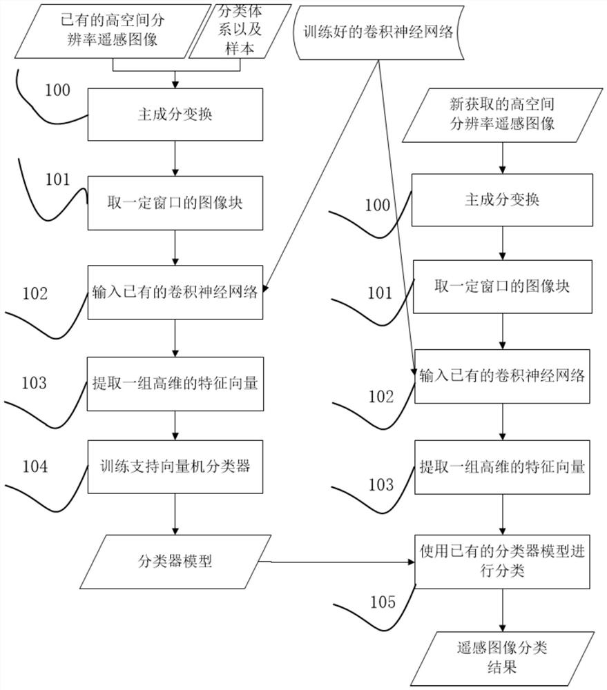
[0025] An example of implementation of a transfer learning method for high spatial resolution remote sensing images based on depth features using the present invention is attached figure 1 As shown, the attached figure 1 Describe it.

[0026]The processing unit 100 performs principal component transformation on current common multi-band high-spatial-resolution remote sensing images (such as four-band IKONOS satellite multispectral images, eight-band WorldView-4 satellite multispectral images), using the first three components ( That is, the first three components with the most information) generate a three-band image.

[0027] The processing unit 101 reads an image block of an odd window size (such as 5×5, 7×7, 9×9, 11×11) with the geometric center of each pixel of the image obtained in the processing unit 100, the image A block acts as a representation that the pixel has spatial context information.

[0028] The processing unit 102 inputs the existing convolutional neura...


PUM


Abstract

The invention provides a high spatial resolution remote sensing image transfer learning method based on depth features. This method can use existing remote sensing images and sample information to directly classify newly acquired remote sensing images, thus providing support for remote sensing rapid monitoring. The method includes the following steps: for the source domain image and the target domain image, use the principal component transformation to extract the first three principal component components respectively; for the generated new image of the three bands, extract the image block input centered on each pixel To the trained multi-layer convolutional neural network; output the last fully connected layer of the convolutional neural network to obtain the depth feature representation of the pixel; for the source domain image and the training samples of the source domain, use support based on the extracted depth features The vector machine classifier is trained to obtain a classifier; for the target domain image, use the obtained support vector classifier to directly classify, and complete the transfer learning from the source domain image and the corresponding relationship between categories to the target domain.

Description

technical field [0001] The present invention relates to remote sensing image processing technology, in particular, relates to a high spatial resolution remote sensing image transfer learning method based on depth features, the method can be based on the existing high spatial resolution remote sensing images and sample data, the newly acquired remote sensing Images are automatically classified without samples, so as to quickly process remote sensing images and provide support for remote sensing monitoring. Background technique [0002] Remote sensing technology is currently widely used in geoscience applications, such as forest resource planning, crop yield estimation, environmental assessment, disaster monitoring, etc. Remote sensing image classification technology is a key step in converting remote sensing images from data to information. In terms of whether training samples are needed, remote sensing image classification methods can be divided into supervised classificati...

Claims


Application Information

Patent Timeline
Patent Type & Authority Patents(China)
IPC IPC(8): G06K9/00G06K9/62
CPCG06V20/13G06F18/217G06F18/2411
Inventor 霍连志赵理君张伟郑柯唐娉
Owner INST OF REMOTE SENSING & DIGITAL EARTH CHINESE ACADEMY OF SCI
Why Eureka
Try Eureka