
Internet of vehicles routing addressing method combining geographic position and IP address

A technology of IP address and geographical location, applied in data exchange network, digital transmission system, electrical components, etc., can solve problems such as location information failure and routing failure

Active Publication Date: 2017-10-20
BEIJING UNIV OF POSTS & TELECOMM
View PDF4 Cites 7 Cited by
  • Summary
  • Abstract
  • Description
  • Claims
  • Application Information

AI Technical Summary

Problems solved by technology

[0005] The present invention provides a vehicle networking routing addressing method that combines geographic location and IP address to solve the problem of location information failure during the data routing between the vehicle-mounted unit and the roadside unit in the prior art, thereby causing the roadside unit to send response data to the vehicle-mounted unit When the package is packaged, it is easy to have the problem of routing failure

Method used


Image

  • Internet of vehicles routing addressing method combining geographic position and IP address
  • Internet of vehicles routing addressing method combining geographic position and IP address
  • Internet of vehicles routing addressing method combining geographic position and IP address

Examples


Embodiment Construction

[0047]In order to make the purpose, technical solutions and advantages of the embodiments of the present invention clearer, the technical solutions in the embodiments of the present invention will be clearly and completely described below in conjunction with the drawings in the embodiments of the present invention. Obviously, the described embodiments It is a part of embodiments of the present invention, but not all embodiments. Based on the embodiments of the present invention, all other embodiments obtained by persons of ordinary skill in the art without creative efforts fall within the protection scope of the present invention.

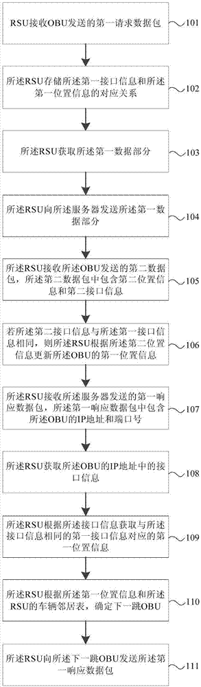
[0048] figure 1 It is a flow chart of Embodiment 1 of the Internet of Vehicles routing addressing method that combines geographic location and IP address in the present invention, as shown in figure 1 As shown, the method of this embodiment may include:

[0049] Step 101, the RSU receives the first request packet sent by the OBU.

[0050] Among ...


PUM


Abstract

The invention provides an internet of vehicles routing addressing method combining a geographic position and an IP address. The internet of vehicles routing addressing method combining the geographic position and the IP address comprises the following steps: a RSU receives a first request data packet sent by an OBU; the RSU stores a corresponding relation of the first interface information and the first position information; the RSU acquires the first data part; the RSU sends the first data part to a server; the RSU receives a second data packet sent by the OBU; the RSU updates the first position information of the OBU; the RSU receives a first response data packet sent by the server; the RSU acquires the interface information in the IP address of the OBU; the RSU acquires the corresponding first position information; the RSU determines the next-hop OUB; and the RSU sends the first response data packet to the next-hop OBU. By combining the geographic position and the IP address, the most suitable routing path can be selected according to the geographic positions of the opposite sides when the data packet is transmitted between the OBU and the RSU.

Description

technical field [0001] The present invention relates to vehicle-road coordination technology, in particular to a vehicle network routing addressing method combining geographic location and Internet Protocol (Internet Protocol, hereinafter referred to as IP) address. Background technique [0002] Vehicle-road collaboration technology is an important part of the intelligent transportation field. It is a communication technology that effectively integrates the Internet of Things, cloud computing, mobile Internet and data communication transmission technologies, and applies them to real-time data transmission between vehicles and servers. With the help of various technical means, vehicle-road collaboration can build a bridge for information interaction between vehicles and the outside world, improving the real-time and high efficiency of traffic information interaction. [0003] In the existing vehicle cloud client server communication system, in order to transmit information be...

Claims


Application Information

Patent Timeline
IPC IPC(8): H04L12/741H04L29/06H04L29/08H04L45/74
CPCH04L45/74H04L67/12H04L69/22H04L67/52
Inventor 朱孔林蒲霖张琳
Owner BEIJING UNIV OF POSTS & TELECOMM
Features
  • Generate Ideas
  • Intellectual Property
  • Life Sciences
  • Materials
  • Tech Scout
  • Unparalleled Data Quality
  • Higher Quality Content
  • 60% Fewer Hallucinations
Learn More