
Grid compensation-based mono-phase full-coverage remote sensing data retrieval method

A technology of remote sensing data and grid, applied in the direction of electrical digital data processing, special data processing applications, instruments, etc., can solve the problem of no cloud cover identification function, etc.

Pending Publication Date: 2017-10-24
北京四维新世纪信息技术有限公司
View PDF3 Cites 9 Cited by
  • Summary
  • Abstract
  • Description
  • Claims
  • Application Information

AI Technical Summary

Problems solved by technology

At present, the single-temporal full-coverage data retrieval method for a specific area is mainly based on the spatial secondary filtering remote sensing data single-temporal full-coverage retrieval method. to judge whether it is fully covered, but this method does not have the function of cloud identification, and the final remote sensing data more or less contains cloud

Method used


Image

  • Grid compensation-based mono-phase full-coverage remote sensing data retrieval method
  • Grid compensation-based mono-phase full-coverage remote sensing data retrieval method
  • Grid compensation-based mono-phase full-coverage remote sensing data retrieval method

Examples


Embodiment Construction

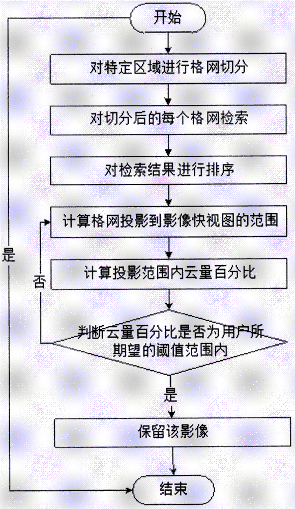
[0010] The concrete implementation process of the present invention is as figure 2 shown.

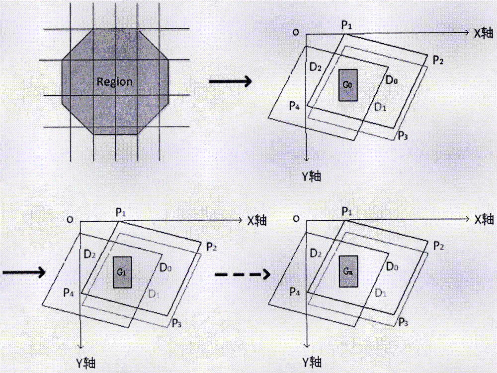
[0011] First, divide the area according to the five-layer and fifteen-level segmentation standard, and divide it into small grids called G i (0≤i≤n, n is the total number of grids to be divided into).

[0012] In the next step, the image data set D covering each grid is retrieved separately from the massive remote sensing data set j (0≤j≤m, m is the total number of remote sensing images covering the grid), and D j Perform weight sorting Sort(D j ), this method first sorts by time priority.

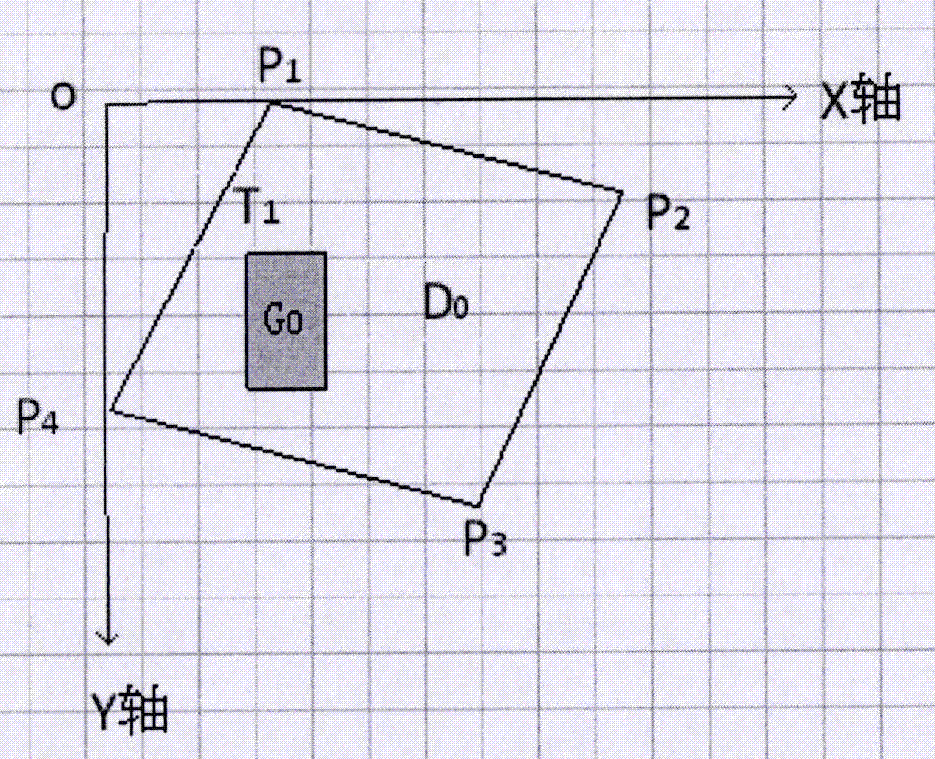
[0013] The next step is to calculate the grid G 0 Projected to data D 0 The position in the quick view. Put a grid and the geometry of one of the original images into the axes, such as image 3 Shown, D 0 represents the original image, G 0 Indicates the grid, where D 0 The coordinates of the four points are P 1 (x 1 ,y 1 ), P 2 (x 2 ,y 2 ), P 3 (x 3 ,y 3 ), P 4 (x 4 ,y 4 ), G...


PUM


Abstract

The invention discloses a grid compensation-based mono-phase full-coverage remote sensing data retrieval method. The method comprises the following steps of: firstly segmenting a specific area into small grids according to a five-layer fifteen-level segmentation standard; respectively retrieving image data which respectively covers each grid from a mass remote sensing data set; carrying out weight sorting on the retrieved image data and calculating positions of the grids projected to an image overview; calculating a cloud cover percentage of the image overview in a projection range by adoption of a rapid overview cloud cover threshold estimation method; if the cloud cover percentage is in a threshold range expected by users, retaining remote sensing images covering the grids; and finally circularly retrieving cloud-free mono-phase full-coverage data of all the grids.

Description

technical field [0001] The technical solution of the invention belongs to the remote sensing application field. Background technique [0002] With the rapid development of remote sensing application technology, remote sensing image data has become a valuable resource for people to obtain information. The amount of remote sensing image data has grown to PB level. Remote sensing image retrieval is an important means of obtaining massive remote sensing data information. At present, the single-temporal full-coverage data retrieval method for a specific area is mainly based on the spatial secondary filtering remote sensing data single-temporal full-coverage retrieval method. To judge whether it is fully covered, but this method has no cloud recognition function, and the final remote sensing data more or less contains clouds. Contents of the invention [0003] Aiming at the problems existing in the existing methods, the purpose of the present invention is to realize rapid retri...

Claims


Application Information

Patent Timeline
Patent Type & Authority Applications(China)
IPC IPC(8): G06F17/30G06K9/00
CPCG06F16/583G06V20/13
Inventor 黄祥志王栋余涛张帅民何方园
Owner 北京四维新世纪信息技术有限公司
Learn More