Vehicular point cloud clustering method and system

A clustering method and point cloud technology, applied in the field of vehicle-mounted laser scanning data processing, can solve problems such as ground object adhesion, seriousness, insufficient segmentation or over-segmentation

Inactive Publication Date: 2017-10-24
WUHAN UNIV
View PDF4 Cites 21 Cited by
  • Summary
  • Abstract
  • Description
  • Claims
  • Application Information

AI Technical Summary

Problems solved by technology

However, urban streetscapes are densely populated with vertically distributed features, and the adhesion between features is serious. In this case

Method used


Image

  • Vehicular point cloud clustering method and system
  • Vehicular point cloud clustering method and system
  • Vehicular point cloud clustering method and system

Examples


Embodiment Construction

[0072] The technical solutions of the present invention will be further specifically described below in conjunction with the accompanying drawings and embodiments.

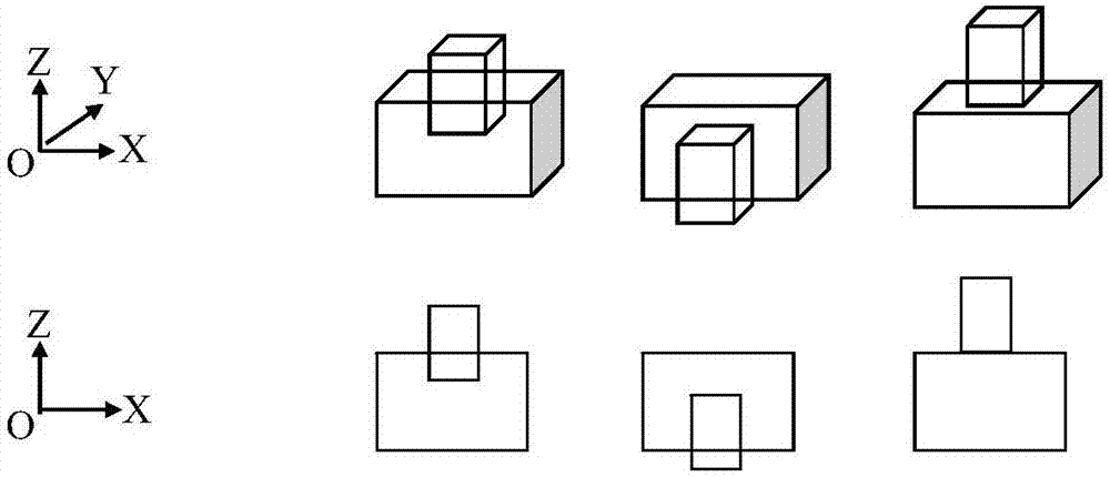
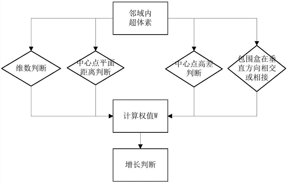
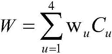
[0073] The invention proposes a vehicle-mounted point cloud clustering method based on spatial context association. In this method, the density-based spatial clustering algorithm DBSCAN is used to segment point clouds to form supervoxels. By analyzing the characteristics of supervoxels and their spatial context correlations, multi-factor weights are used to cluster vehicle-mounted point clouds. In the clustering process, not only the spatial distance of points is considered, but also the spatial context association of neighboring points is combined, which greatly improves the problem of over-segmentation or under-segmentation of vehicle-mounted point cloud clustering.

[0074] The data in the embodiment is the city street point cloud data obtained by the Reigle vux-1 ground laser scanner, and the number of point c...


PUM


Abstract

The invention provides a vehicular point cloud clustering method and system. The vehicular point cloud clustering method comprises carrying out de-noising and filtering on point clouds, removing scattered noise points on the point clouds, carrying out filtering processing on the point clouds, and distinguishing between ground points and non-ground points; segmenting the point clouds to generate super voxels, segmenting the non-ground points by means of a spatial clustering algorithm based on the density to generate the super voxels, and guaranteeing that different surface features do not adhere to each other; clustering the point clouds which have spatial context linkage, analyzing features and the spatial context linkage of the super voxels, carrying out region growing on the super voxels by integrating multifactor weights, and completing point cloud clustering. According to the invention, the problem that during the vehicular point cloud clustering process, over-segmentation or insufficient segmentation occurs is improved, the demand of obtaining 3d spatial information quickly is satisfied, and the vehicular point cloud clustering method and system have an important market value.

Description

technical field [0001] The invention relates to the technical field of vehicle-mounted laser scanning data processing, in particular to a vehicle-mounted point cloud clustering method and system combined with spatial context association. Background technique [0002] The point cloud data acquired by the vehicle-borne laser scanning system (Vehicle-borne Laser Scanning, VLS) has the characteristics of high density, high precision, and fast acquisition. At present, scholars at home and abroad have conducted a lot of research on the application of point cloud data, among which vehicle-mounted point cloud clustering is an important part of VLS data processing and information extraction, and is the premise and key link to realize automatic recognition of ground objects. [0003] The current common point cloud clustering methods can be divided into partition clustering, hierarchical clustering, grid clustering and density clustering. The division clustering method depends on the ...

Claims


Application Information

Patent Timeline
IPC IPC(8): G06K9/00G06K9/62
CPCG06V20/588G06F18/23
Inventor 刘亚文张颖
Owner WUHAN UNIV
Why Eureka
Try Eureka