Eureka AIR delivers breakthrough ideas for toughest innovation challenges, trusted by R&D personnel around the world.

Method for carrying out high-precision relative navigation based on GNSS through employing single receiver

A technology of relative navigation and receiver, applied in the field of navigation

Inactive Publication Date: 2017-11-17
BEIHANG UNIV
View PDF4 Cites 4 Cited by
  • Summary
  • Abstract
  • Description
  • Claims
  • Application Information

AI Technical Summary

Problems solved by technology

And this model will also have the problem of ambiguity resolution, and the resolution of ambiguity is still very challenging for dynamic aircraft, and because the flight environment will be affected by cycle slip factors
Relative navigation must use two receiver data at the same time to achieve relative position resolution, which has certain limitations for further applications

Method used


Image

  • Method for carrying out high-precision relative navigation based on GNSS through employing single receiver
  • Method for carrying out high-precision relative navigation based on GNSS through employing single receiver
  • Method for carrying out high-precision relative navigation based on GNSS through employing single receiver

Examples


Embodiment Construction

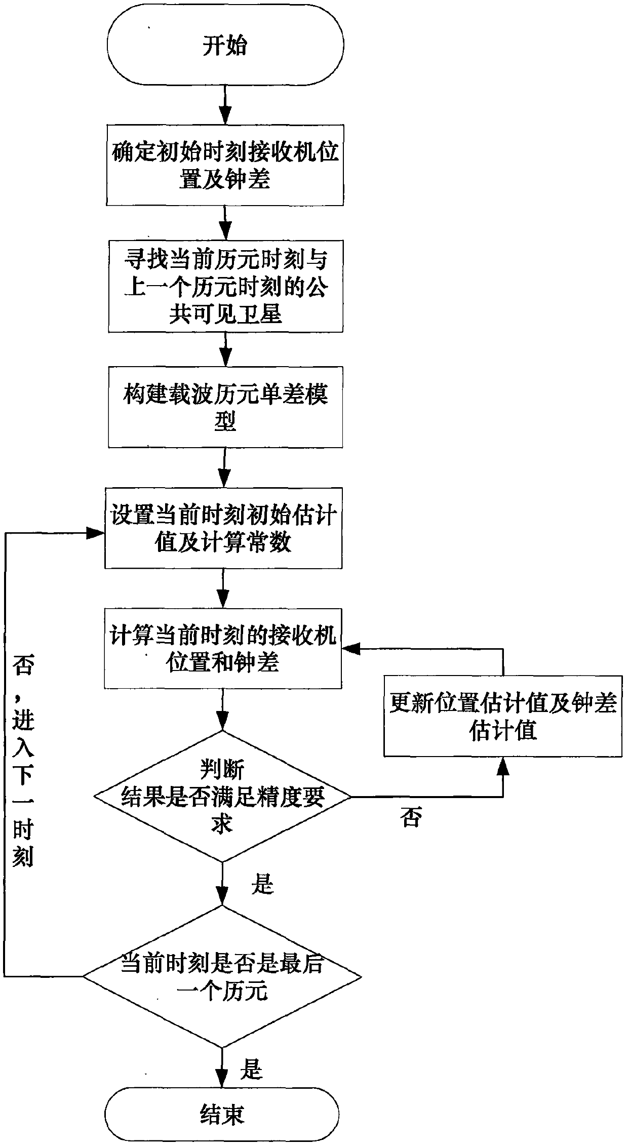
[0082] The following will be combined with figure 1 and the technical solution further describe the specific implementation process of the present invention in detail.

[0083] Step 1: Determine the receiver position and clock error at the initial time

[0084] For the initial time, use the single-point positioning method prepared in the preparatory work to determine the initial time position and clock error. The result of utilization is to obtain the receiver position and clock error at the initial time.

[0085] This step corresponds to the attached figure 1 The first box in .

[0086] Step 2: Find the publicly visible satellites between the current epoch and the previous epoch

[0087] Find the satellites that were also searched at the previous time among the visible satellites searched at the current epoch, and write down the identification number of the satellites for future use. The number of public satellites is represented by n.

[0088] This step corresponds to t...


PUM


Abstract

The invention discloses a method for carrying out high-precision relative navigation based on GNSS through employing a single receiver, and the method comprises the following steps: 1, making preparation; 2, determining the position of the receiver and a clock error at an initial moment; 3, searching a public visible satellite at a current epoch moment and a former epoch moment; 4, building a carrier epoch single-difference model; 5, setting an initial estimation value and a calculation constant at a current moment; 6, calculating the position of the receiver and the clock error at the current moment; 7, judging whether the calculation result meets the requirements or not; 8, updating a position estimation value and a clock error estimation value 9, judging whether the current moment is the last epoch or not. The carrier epoch single-difference model is built through the above flow, and a single-point positioning method is used as assistance. The method achieves the high-precision navigation through a relative positioning method, and the method is implemented through the single receiver, so the method has low requirements, is low in cost, and facilitates the popularization and application.

Description

technical field [0001] The invention relates to an autonomous relative navigation method for a moving carrier using a single GNSS (Global Navigation Satellite System) receiver, belonging to the technical field of navigation. Background technique [0002] Global Navigation Satellite System (GNSS, Global Navigation Satellite System) refers to all satellite navigation systems, including global, regional and enhanced satellite navigation systems, such as the US Global Positioning System (GPS, Global Positioning System), Russia's Glonass, Europe's Galileo, China's Beidou satellite navigation system and related augmentation systems, also covers other satellite navigation systems under construction and to be built in the future. [0003] GNSS-based navigation technology has been applied to various fields. Generally speaking, the measurement quantity used in the single point positioning method is pseudorange, and its accuracy is poorer than that of the carrier measurement, and the ...

Claims


Application Information

Patent Timeline
IPC IPC(8): G01S19/51
CPCG01S19/51
Inventor 陈培杜浩张键
Owner BEIHANG UNIV
Why Eureka
Eureka Blog
Learn More