Real landform fast modeling method and landslide visualization technology

A terrain model and terrain technology, applied in image data processing, animation production, 3D image processing, etc., can solve problems such as difficulty, slow rendering speed, and simulation effects

Inactive Publication Date: 2017-11-28
BEIJING NORMAL UNIVERSITY
View PDF2 Cites 13 Cited by
  • Summary
  • Abstract
  • Description
  • Claims
  • Application Information

AI Technical Summary

Problems solved by technology

[0004] For the simulation of landforms, natural landscape models such as vegetation, soil and rocks can be added to the surface. The results obtained by this method are usually very close to the real natural environment, but it is difficult. At the same time, these models will also affect the simulation of the landslide process, resulting in rendering speed. slow down

Method used


Image

  • Real landform fast modeling method and landslide visualization technology
  • Real landform fast modeling method and landslide visualization technology
  • Real landform fast modeling method and landslide visualization technology

Examples


Embodiment Construction

[0023] The present invention will be described in further detail below in conjunction with the accompanying drawings.

[0024] figure 1 Flowchart of the rapid modeling and landslide simulation process for realistic terrain. The following will combine figure 1 An exhaustive description of our method is given in two parts.

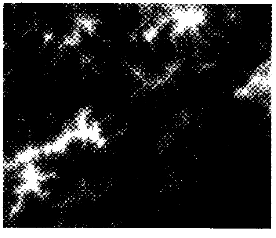
[0025] Step 1: Import the terrain elevation grayscale map into Blender, obtain the terrain model grid and adjust the grid, and automatically synthesize the texture image to draw UV maps for the terrain surface to simulate different landforms:

[0026] will be like figure 2 The grayscale image shown is loaded into Blender as an imported plane, and the plane is subdivided into several grids. Using the "Displacement" modifier can quickly adjust the height of each grid point to be proportional to the grayscale data. Proportional position. We choose different values ​​for the number of subdivisions and displacement strength to simulate respectively, and com...


PUM


Abstract

The invention discloses a visualized landslide simulation method for fast generating a real landform model, simulating a real landform environment and, on the basis of that, performing Boolean operation and rigid body breaking. The visualized landslide simulation method comprises steps of importing a landform elevation grey-scale map into a Blender to obtain a landform model grids and performing adjustment on the grids, automatically synthesizing a texture image to draw UV maps for a landform curve surface to simulate different landforms, (2) designing a fragment generation pipeline, wherein the fragment generation pipeline designing comprises steps of using a landslide body obtained through the Boolean operation based on a Sutherland-Hodgman algorithm to transform the collided rigid body into a point cloud on a fundamental basis, performing triangularization on the point cloud to obtain a Thiessen polygon and generating a Voronoi cells to simulate landside fragments, and (3) fitting the landform data to generate fragment interactive blocking surfaces, performing a combination operation with the fragments and generating a successive frame animation.

Description

technical field [0001] The invention belongs to the field of computer image processing technology and computer animation generation, and relates to a fast modeling method of real terrain and a landslide simulation method based on Boolean operation and rigid body breaking. Background technique [0002] The initial simulation of the terrain is to read the data in the DEM file, convert the coordinates of the real environment into the coordinates in the computer 3D world and display them on the screen one by one, thus obtaining the point cloud model of the terrain. However, the model obtained by this method is discrete, which is not conducive to observation and further correction, and when the amount of data is large, this method is slow. Therefore, 3D modeling software is often used to build terrain models now. [0003] In 3D modeling software, the color data of the image can be converted into 3D coordinate data. Using this, the terrain elevation map can be converted into a 3D...

Claims


Application Information

Patent Timeline
Patent Type & Authority Applications(China)
IPC IPC(8): G06T13/60G06T15/10G06T19/20
CPCG06T13/60G06T15/10G06T19/20
Inventor 郑新吕辰雷李琨杨净邱睿黎玥嵘尹乾
Owner BEIJING NORMAL UNIVERSITY
Why Eureka
Try Eureka