Highway three-dimensional model data conversion method and system

A 3D technology for model data and roads, applied in image data processing, 3D modeling, instruments, etc., can solve problems such as not intuitive enough, impossible to display, difficult to find, etc., and achieve the effect of easy search

Inactive Publication Date: 2017-12-01
GUANGDONG KENUO SURVEYING ENG CO LTD
View PDF5 Cites 9 Cited by
  • Summary
  • Abstract
  • Description
  • Claims
  • Application Information

AI Technical Summary

Problems solved by technology

However, through the station location information, it cannot be directly displayed on the map
[0004] At the same time, in the process of road maintenance, when...

Method used


Image

  • Highway three-dimensional model data conversion method and system
  • Highway three-dimensional model data conversion method and system
  • Highway three-dimensional model data conversion method and system

Examples


Embodiment 1

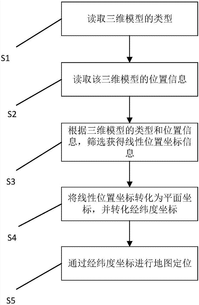
[0076] Specifically, see figure 1 , which is a flow chart of the steps of the method for converting road 3D model data according to Embodiment 1 of the present invention. The invention provides a conversion method of road three-dimensional model data, comprising the following steps:

[0077] Step S101: Read the type of the 3D model.

[0078] For details, please refer to Table 1 below. The type of the three-dimensional model described in step S101 is marked by a number, and the corresponding type of the three-dimensional model is obtained by reading the number. Wherein, the type of the three-dimensional model includes: road surface, slope, bridge, culvert, tunnel, toll station, service area and ancillary facilities; guardrail.

[0079] Table 1

[0080]

[0081]

[0082] Step S102: Read the location information of the 3D model.

[0083] Specifically, the location information read in this step includes: model coordinate location information and business location inform...

Embodiment 2

[0111] The difference between this embodiment and Embodiment 1 is that this embodiment converts plane coordinates into linear coordinates. For details, please refer to Image 6 , which is the conversion method of the highway three-dimensional model data in the second embodiment of the present invention. In addition, the present invention also provides another conversion method of road three-dimensional model data, comprising the following steps:

[0112] Step S201: Read the type of the 3D model.

[0113] Step S202: Read the location information of the 3D model.

[0114] Step S203: According to the type and position information of the 3D model, obtain linear position coordinate information through screening.

[0115] Step S204: Transform the plane position coordinates into linear coordinates.

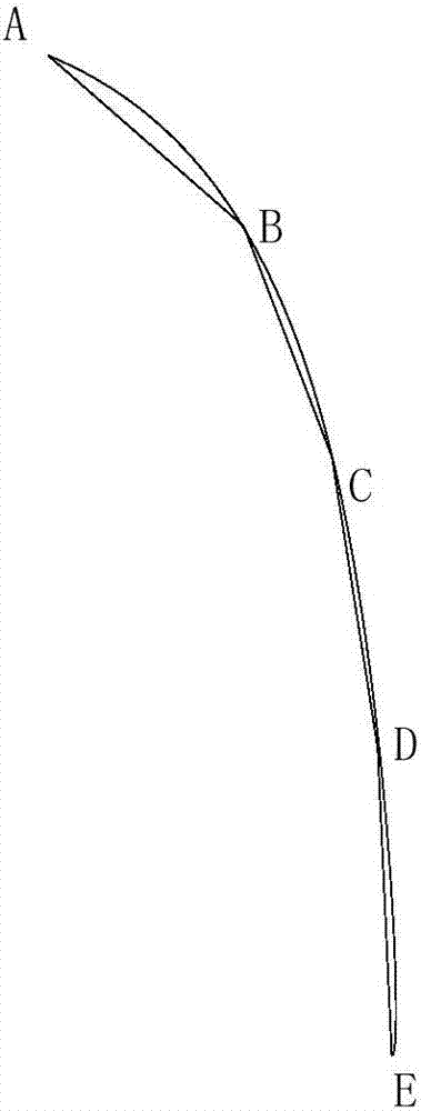
[0116] Please refer to the specific Figure 7 , which is a schematic diagram of the location of road sections in Embodiment 2 of the present invention. In the step 204, it specific...


PUM


Abstract

The invention provides a highway three-dimensional model data conversion method comprising the following steps that step S101: the type of a three-dimensional model is read; step S102: the position information of the three-dimensional model is read; step S103: linear position coordinate information is obtained through screening according to the type and the position information of the three-dimensional model; step S104: the linear position coordinates are converted into plane coordinates and converted into latitude and longitude coordinates; and step S105: map positioning is performed through the latitude and longitude coordinates. Compared with the methods in the prior art, the linear coordinates can be converted into the plane coordinates, establishment of mutual transformation between the plane coordinates and the linear coordinates is completed and then the system user describes the object position required to be expressed according to the universal linear coordinates, and the coordinates are converted into the latitude and longitude coordinates for expression in the three-dimensional map. The invention also provides a highway three-dimensional model data conversion system for realizing the method.

Description

technical field [0001] The invention relates to a data conversion method, in particular to a data conversion method for a three-dimensional road model; the invention also provides a data conversion system for a three-dimensional road model. Background technique [0002] The digital terrain model (Digital Terrain Model, DTM, referred to as digital model) refers to the digital representation of various information such as terrain surface morphology. It is a data group organized according to a certain structure. The digital description of attribute features is usually expressed by a plane coordinate system, and the terrain attribute feature is the elevation of ground points on each plane position (X, Y), which is the digital expression of terrain undulations and is the basis for establishing different levels. An integral part of the geographic information system. [0003] Through comparative analysis of topographic maps, three-dimensional graphics are more intuitive than plane...

Claims


Application Information

Patent Timeline
IPC IPC(8): G06T17/05
CPCG06T17/05
Inventor 祖为国赵阅兵雷伟刚曾强潘屹峰马海毅陈隽敏王庭松蔡文婷王昊黄晶李琦
Owner GUANGDONG KENUO SURVEYING ENG CO LTD
Why Eureka
Try Eureka