Geo-BTree-based range query method and device

A query method and range of technology, applied in special data processing applications, instruments, electrical digital data processing and other directions, can solve problems such as low retrieval efficiency, and achieve the effect of high query efficiency

Active Publication Date: 2018-03-06
KUNMING UNIV OF SCI & TECH
View PDF8 Cites 15 Cited by
  • Summary
  • Abstract
  • Description
  • Claims
  • Application Information

AI Technical Summary

Problems solved by technology

[0006] The invention provides a range query method and device based on Geo-BTree, the purpose is to effectively support any range query; effectively solve

Method used


Image

  • Geo-BTree-based range query method and device
  • Geo-BTree-based range query method and device
  • Geo-BTree-based range query method and device

Examples


Embodiment 1

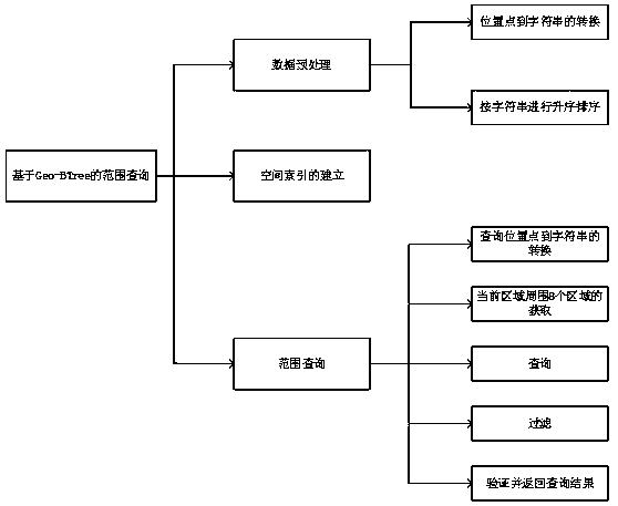
[0044] Embodiment 1: as Figure 1-10 As shown, a range query method based on Geo-BTree, including:

[0045] Data preprocessing steps:

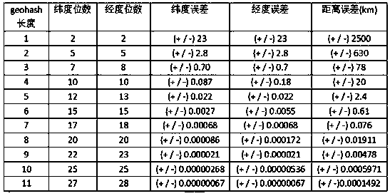
[0046] Step 111, according to the geohash precision table (such as figure 2 shown), set the geohash encoding length n to 8, and the longitude and latitude bit strings are 20 bits respectively;

[0047] Step 112, convert the position point in D into a character string with a length of 8 through the geohash algorithm, and the implementation method is as follows:

[0048] Example: (19.596412 -99.219501)

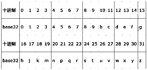
[0049] First divide the latitude range (-90,90) into two intervals (-90,0) and (0,90). If the target latitude is in the previous interval, it is coded as 0, otherwise it is coded as 1. Because 19.596412 belongs to the interval (0,90), it is encoded as 1; then (0,90) is divided into two intervals (0,45) and (45,90), because 19.596412 belongs to the interval (0,45), so Coded as 0; and so on until the length of the bit string is 20. The fina...

Embodiment 2

[0117] Embodiment 2: as Figure 1-10 As shown, a range query method based on Geo-BTree, including:

[0118] The data preprocessing step is to encode all the position points in the data set into a character string with a length of n, sort the position points in the data set according to the lexicographical order according to the character strings, and number the IDs;

[0119] The spatial index building step is to build a B-Tree index structure according to the sorted strings;

[0120] In the range query step, starting from the ID returned by retrieving the B-Tree index structure, two-way search is performed in the record set to obtain the ID in the query domain, and the ID candidate set is obtained after filtering, and the position point corresponding to the ID in the candidate set is verified and returned within the query range location point.

[0121] Further, the data preprocessing step may be set, specifically including the following steps:

[0122] Step 110: Given a dat...


PUM


Abstract

The invention relates to a Geo-BTree-based range query method and device. The method comprises the following steps of: data preprocessing: encoding all the position points in a data set into a character string with a length of n, sorting the position points in the data set according to the character string and a lexicographical order, and numbering IDs for the position points; space index establishment: constructing a B-Tree index structure according to the character string after the sorting; and range query: carrying out bidirectional query by taking an ID returned through retrieving the B-Tree index structure as a starting point so as to obtain IDs in a query domain, filtering the IDs to obtain an ID candidate set, verifying the position points corresponding to the IDs in the candidate set and returning the position points in the query range. According to the method and device, the B-Tree index structure is constructed on the basis of geohash encoding, so that the method and device has relatively high query efficiency and can be directly used in data management systems; and by adoption of a geohash space index method, the query of any range can be effectively supported.

Description

technical field [0001] The invention relates to a Geo-BTree-based range query method and device, belonging to the fields of Database, Range Search, Location-Based Service (LBS) and the like. Background technique [0002] In recent years, with the popularization of mobile devices such as smartphones and tablets, the desktop-based Internet era has shifted to the mobile Internet era. At the same time, with the development of positioning technology, such as: GPS, 3G, 4G, WiFi, etc., a large amount of data with location attributes has been generated, and the amount of data has increased sharply. [0003] In the face of massive spatial data, efficiently supporting spatial query is an urgent problem to be solved. Spatial indexes are used to filter and exclude a large number of geographical objects that are not related to specific spatial operations, thereby reducing the scope of spatial operations. In order to efficiently support spatial queries, an efficient spatial index structu...

Claims


Application Information

Patent Timeline
IPC IPC(8): G06F17/30
CPCG06F16/2246
Inventor 沈兵林贾连印丁家满游进国李晓武左喻灏胡俊涛雷妍
Owner KUNMING UNIV OF SCI & TECH
Why Eureka
Try Eureka