A trie-based range query method and device
A query method and scope technology, which can be applied to other database queries, instruments, geographic information databases, etc., can solve problems such as large space overhead, and achieve the effect of reducing space overhead and improving query efficiency.
- Summary
- Abstract
- Description
- Claims
- Application Information
AI Technical Summary
Problems solved by technology
Method used
Image
Examples
Embodiment 1
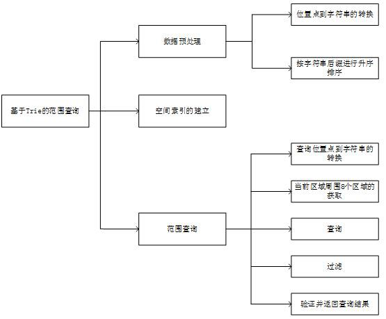
[0041] Embodiment 1: as Figure 1-7 As shown, a Trie-based range query method, including
[0042] Data preprocessing steps:
[0043] Step 111, according to the geohash precision table (such as figure 2 shown), set the geohash encoding length n to 8, and the longitude and latitude bit strings are 20 bits respectively;
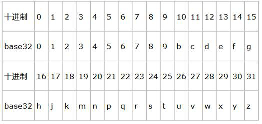
[0044] Step 112, convert the position point in D into a character string with a length of 8 through the geohash algorithm, and the implementation method is as follows:
[0045] Example: (19.596412 -99.219501)
[0046] First divide the latitude range (-90,90) into two intervals (-90,0) and (0,90). If the target latitude is in the previous interval, it is coded as 0, otherwise it is coded as 1. Because 19.596412 belongs to the interval (0,90), it is encoded as 1; then (0,90) is divided into two intervals (0,45) and (45,90), because 19.596412 belongs to the interval (0,45), so Coded as 0; and so on until the length of the bit string is 20. The final encoding...
Embodiment 2
[0093] Embodiment 2: as Figure 1-7 As shown, a Trie-based range query method includes:
[0094] The data preprocessing step is to encode all the position points in the data set into a string of length n, sort the position points in the data set according to the lexicographical order according to the string suffix and number the ID;
[0095] The spatial index building step is to construct a Trie spatial index structure according to the sorted string prefix;
[0096] In the range query step, the location points in the query domain are obtained from the index structure, the candidate set is obtained by filtering, and all the location points in the query range are returned after the candidate set is verified.
[0097] Further, the data preprocessing step may be set, specifically including the following steps:
[0098] Step 110: Given a data set D consisting of a series of location points, the location points in D are encoded into a string s of length n by geohash algorithm; whe...
PUM
 Abstract
Description
Claims
Application Information
 - R&D
- Intellectual Property
- Life Sciences
- Materials
- Tech Scout
- Unparalleled Data Quality
- Higher Quality Content
- 60% Fewer Hallucinations
Browse by: Latest US Patents, China's latest patents, Technical Efficacy Thesaurus, Application Domain, Technology Topic, Popular Technical Reports.
© 2025 PatSnap. All rights reserved.Legal|Privacy policy|Modern Slavery Act Transparency Statement|Sitemap|About US| Contact US: help@patsnap.com


