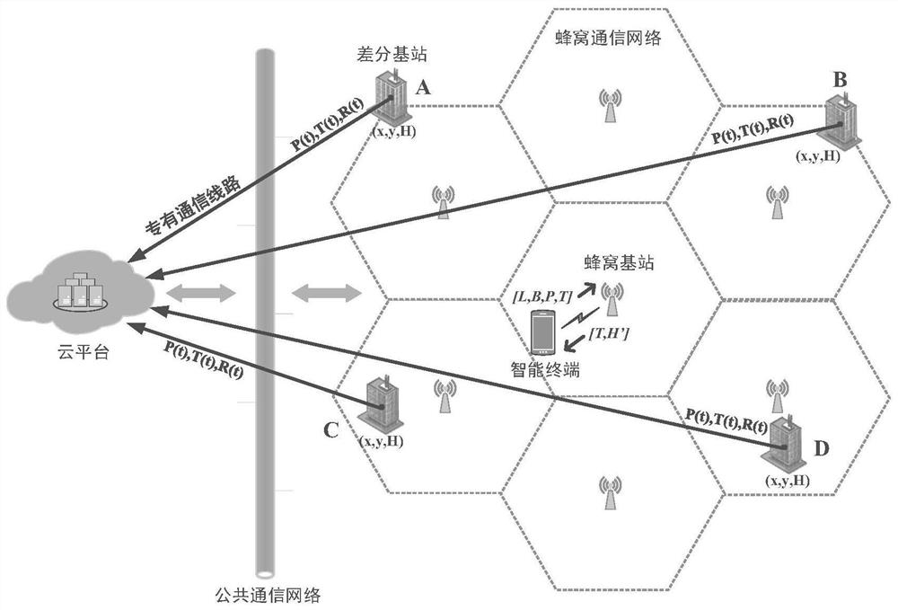
Normal height measurement method, system, server and cloud platform
A measurement system and cloud platform technology, applied in height/horizontal measurement, measurement devices, surveying and navigation, etc., can solve the problems of GNSS satellite signals blocking multipath, inability to work, inconvenient measurement, etc., to achieve a wide range of use, work The effect of high strength and low efficiency
- Summary
- Abstract
- Description
- Claims
- Application Information
AI Technical Summary
Problems solved by technology
Method used
Image
Examples
no. 2 approach
[0071] Second embodiment: if it is assumed that the atmosphere is a homogeneous atmosphere, that is, it is assumed that the density of the atmosphere does not vary with height, then there are:
[0072] (2-2) Calculate the distance d between the terminal and all base stations i And sorting, select the n nearest differential base stations and call the air pressure P at the same moment reported by them i , where i=1,...,n.
[0073] (2-3) Using base station air pressure P i and elevation H i , and the air pressure P at the terminal calculates the altitude H' at the terminal i , the pressure height is calculated according to the pressure height equation of the homogeneous atmosphere
[0074] H' i =7.91(P i -P)+H i
[0075] The unit of elevation is m, and the unit of pressure is hPa.
[0076] (2-4) Calculate n normal heights H' at the terminal according to the air pressure of n base stations i (i=1,...,n), and the final normal high value of the terminal is obtained after i...
no. 3 approach
[0077] The third embodiment: if it is assumed that the atmosphere is an isothermal atmosphere, that is, it is assumed that the temperature of the atmosphere does not vary with height, then there are:
[0078] (2-2) Calculate the distance d between the terminal and all base stations i And sorting, select the n nearest differential base stations and call the air pressure P at the same moment reported by them i and temperature T i , where i=1,...,n.
[0079] (2-3) According to the measured value of the temperature at the i-th base station, and the air pressure P of the base station i and elevation H i , and the air pressure P at the terminal calculates the altitude H' at the terminal i , the pressure height is calculated according to the pressure-height equation of the isothermal atmosphere
[0080]
[0081] where T m Indicates the average temperature in Celsius of the air layer, the unit of elevation is m, and the unit of air pressure is hPa.
[0082] (2-4) Calculate n n...
no. 4 approach
[0083] The fourth embodiment: if it is assumed that the atmosphere is a multivariate atmosphere, that is, it is assumed that the temperature of the atmosphere is linearly transformed with the height, then:
[0084] (2-2) Calculate the distance d between the terminal and all base stations i And sorting, select the n nearest differential base stations and call the air pressure P at the same moment reported by them i and temperature T i , where i=1,...,n.
[0085] (2-3) According to the measured value of the temperature at the i-th base station, and the air pressure P of the base station i and elevation H i , and the air pressure P at the terminal calculates the altitude H' at the terminal i , the pressure height is calculated according to the pressure height equation of the multivariate atmosphere
[0086]
[0087] Among them, the unit of elevation is m, the unit of air pressure is hPa, the unit of temperature is K, and γ is the temperature change rate, and the size is 6...
PUM
 Abstract
Description
Claims
Application Information
 - R&D
- Intellectual Property
- Life Sciences
- Materials
- Tech Scout
- Unparalleled Data Quality
- Higher Quality Content
- 60% Fewer Hallucinations
Browse by: Latest US Patents, China's latest patents, Technical Efficacy Thesaurus, Application Domain, Technology Topic, Popular Technical Reports.
© 2025 PatSnap. All rights reserved.Legal|Privacy policy|Modern Slavery Act Transparency Statement|Sitemap|About US| Contact US: help@patsnap.com


