A signal display method and system based on gis map
A GIS map and signal display technology, applied in image communication, TV system components, digital output to display devices, etc., can solve problems such as inconvenient use, wrong estimation of target area area, and not enough intuitiveness to ensure search efficiency. , the effect of high scheduling efficiency
- Summary
- Abstract
- Description
- Claims
- Application Information
AI Technical Summary
Problems solved by technology
Method used
Image
Examples
Embodiment Construction
[0028] The present invention will be further elaborated below in conjunction with the accompanying drawings.
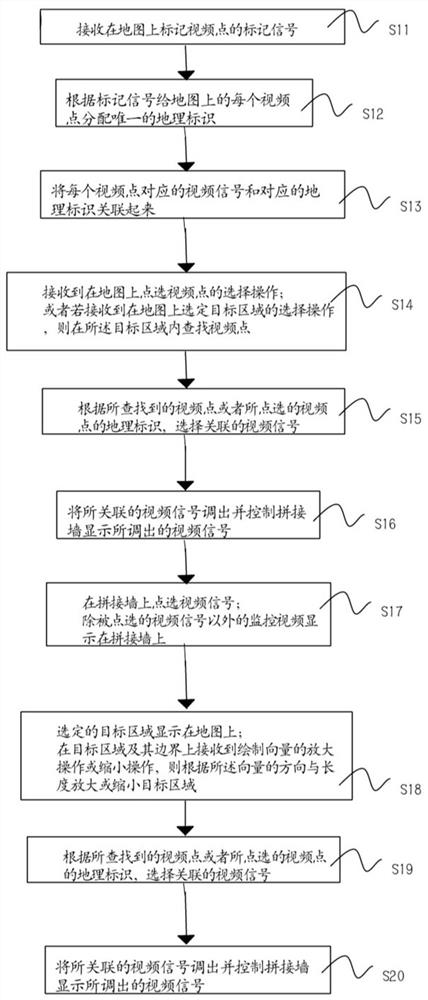
[0029] figure 1 It is a flow chart of an embodiment of the method of the present invention, a signal display method based on a GIS map, the method is used in a splicing wall, the splicing wall is controlled by a control device, and a GIS electronic map is displayed on the control device, step S11 ~S16 is the processing steps of the control device, specifically:
[0030] S11. Receive a marking signal for marking video points on the map.
[0031] S12. Assign a unique geographic identifier to each video point on the map according to the marker signal.
[0032] S13. Associating the video signal corresponding to each video point with the corresponding geographic identifier.
[0033]Steps S11-S13 associate the video point, geographic identifier, and video signal. The video point is equivalent to the camera device, and the camera device is marked on the GIS electronic ma...
PUM
 Abstract
Description
Claims
Application Information
 - R&D
- Intellectual Property
- Life Sciences
- Materials
- Tech Scout
- Unparalleled Data Quality
- Higher Quality Content
- 60% Fewer Hallucinations
Browse by: Latest US Patents, China's latest patents, Technical Efficacy Thesaurus, Application Domain, Technology Topic, Popular Technical Reports.
© 2025 PatSnap. All rights reserved.Legal|Privacy policy|Modern Slavery Act Transparency Statement|Sitemap|About US| Contact US: help@patsnap.com


