
Method, device and system for displaying position of slave UAV based on vision of master UAV

A technology of unmanned aerial vehicles and vision, applied in the direction of camera device, control/adjustment system, three-dimensional position/channel control, etc., can solve problems such as inconvenience

Active Publication Date: 2020-11-06
HANGZHOU HIKVISION DIGITAL TECH
View PDF6 Cites 0 Cited by
  • Summary
  • Abstract
  • Description
  • Claims
  • Application Information

AI Technical Summary

Problems solved by technology

However, since the plane map shows the position of the UAV relative to the ground, the operator observes the air and ground conditions through the pan-tilt camera mounted on the main UAV, that is, what is displayed within the operator's field of view The scene and the position of the slave drone are relative to the master drone, so it is not convenient for the operator to grasp the position information of the slave drone comprehensively and intuitively

Method used


Image

  • Method, device and system for displaying position of slave UAV based on vision of master UAV
  • Method, device and system for displaying position of slave UAV based on vision of master UAV
  • Method, device and system for displaying position of slave UAV based on vision of master UAV

Examples


Embodiment Construction

[0032]The following will clearly and completely describe the technical solutions in the embodiments of the present invention with reference to the accompanying drawings in the embodiments of the present invention. Obviously, the described embodiments are only some of the embodiments of the present invention, not all of them. Based on the embodiments of the present invention, all other embodiments obtained by persons of ordinary skill in the art without making creative efforts belong to the protection scope of the present invention.

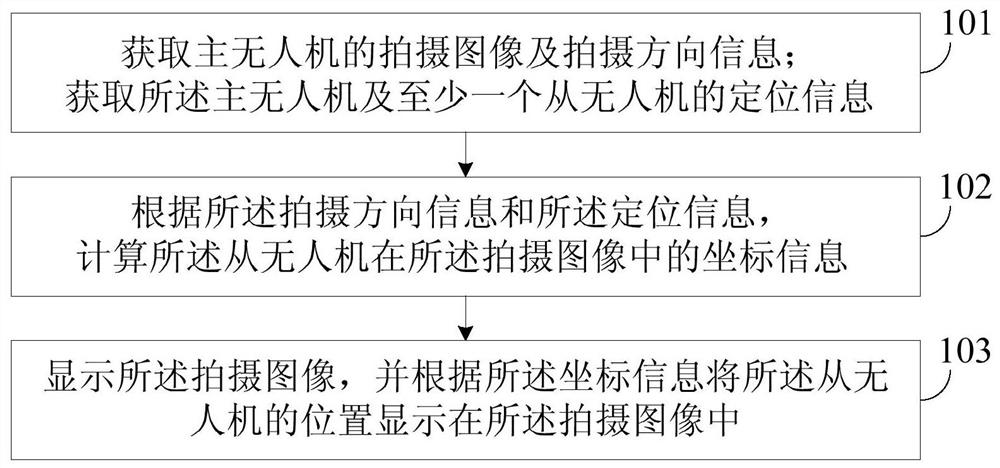
[0033] The embodiment of the invention discloses a method for displaying the position of the slave drone based on the vision of the master drone. see figure 1 , figure 1 It is a flow chart of the position display method of the slave drone based on the vision of the master drone in the embodiment of the present invention, including the following steps:

[0034] Step 101, obtaining the photographed image and shooting direction information of the m...


PUM


Abstract

The embodiment of the invention provides a method, a device and a system for displaying the position of a slave drone from master drone vision. The method comprises the following steps: acquiring theshooting image and the shooting direction information of a master drone; acquiring the positioning information of the master drone and at least one slave drone; calculating the coordinate informationof the slave drone in the shooting image according to the shooting direction information and the positioning information; and displaying the shooting image, and displaying the position of the slave drone in the shooting image according to the coordinate information. The position information of the slave drone in the view field of the slave drone through using the method, the device and the system.

Description

technical field [0001] The invention relates to the technical field of unmanned aerial vehicle information fusion display, in particular to a method, device and system for displaying the position of a slave unmanned aerial vehicle based on the vision of a master unmanned aerial vehicle. Background technique [0002] With the rapid development of drone technology, the application scenarios of drones are becoming wider and wider, and the advantages of use are becoming more and more obvious, especially in complex application scenarios. Compared with the traditional execution method, the use of multiple drones The aircraft cooperates with each other to perform tasks, which can avoid casualties and lower the cost of use. For example, in the high-altitude surveillance scene, the master drone equipped with a gimbal camera can observe the air and ground conditions, use the slave drone equipped with searchlights for lighting, and use the slave drone equipped with a megaphone to make ...

Claims


Application Information

Patent Timeline
Patent Type & Authority Patents(China)
IPC IPC(8): G01C11/02G05D1/10
CPCG01C11/02G05D1/104
Inventor 桑云
Owner HANGZHOU HIKVISION DIGITAL TECH
Learn More