Cross-screen and cross-platform measurable live-action map organization method

A real-world map, cross-platform technology, applied in the field of cross-screen and cross-platform measurable real-world map organization, which can solve the problems of incompatibility with offline scenarios on mobile terminals, and lack of offline operation capabilities.

Active Publication Date: 2018-05-11
江苏省测绘研究所
View PDF5 Cites 8 Cited by
  • Summary
  • Abstract
  • Description
  • Claims
  • Application Information

AI Technical Summary

Problems solved by technology

The script execution performance of the mobile browser is not enough to support the local query and retrieval of 3D spatial data. As a result, the existing general-purpose street view or measurable real-scene mobile applications usually do not have the ability to run offline
[0014] d) Web applications coupled with traditional front-end and back-end business logic cannot be compatible with the use of mobile offline scenarios

Method used


Image

  • Cross-screen and cross-platform measurable live-action map organization method
  • Cross-screen and cross-platform measurable live-action map organization method
  • Cross-screen and cross-platform measurable live-action map organization method

Examples


Embodiment Construction

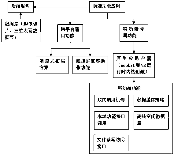
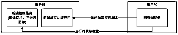
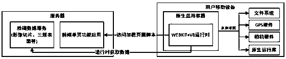
[0034] In order to make the purpose and technical solutions of the embodiments of the present invention clearer, the technical solutions of the embodiments of the present invention will be described clearly and completely in conjunction with the accompanying drawings of the embodiments of the present invention. Obviously, the described embodiments are part of the embodiments of the present invention, rather than all of the embodiments. Based on the described embodiments of the present invention, all other embodiments obtained by a person of ordinary skill in the art without creative work shall fall within the protection scope of the present invention.

[0035] Those skilled in the art can understand that, unless otherwise defined, all terms (including technical terms and scientific terms) used herein have the same meanings as commonly understood by those of ordinary skill in the art to which the present invention belongs. It should also be understood that terms such as those defi...


PUM


Abstract

The invention discloses a cross-screen cross-platform measurable live-action map organization method. The method comprises the following steps of: separation of a front end and a rear end: establishing a front end and rear end separated desktop end live-action map web application framework; cross-platform general function: adopting a response type layout scheme and a touch screen compatibility function-supported browser in a two-dimensional layout structure of a live-action map application; mobile end exclusive function: packaging a Webkit and a V8 kernel in a native application container, andunifying compatibility, for an HTML5 standard, of a mobile end and a desktop end; and packaging a local function interface and a file reading/writing access interface of the mobile end through a self-defined interface, and self-defining a communication standard to realize a bidirectional calling mechanism of JavaScrip and Java of the mobile end. According to the method, once development and multi-platform deployment of multi-platform general functions are realized, personality characteristics of mobile platforms can be considered, and local function interface of the mobile platforms can be seamlessly called, so that measurable live-action map using experience similar to native applications can be provided.

Description

Technical field [0001] The invention relates to the technical field of a method for organizing a measurable real-scene image map of surveying and mapping geographic information, in particular to a cross-screen and cross-platform method for organizing a measurable real-scene image map. Background technique [0002] Street View uses panoramic cameras and positioning equipment to record the field image information of the position sequence. Users can only get the visual model of the predetermined position and the rough space model based on a limited number of positioning points. [0003] The measurable real image is based on the basic display principle of street view, and at the same time, three-dimensional surface position information along the line is collected through vehicle-mounted or ship-borne mobile measurement technology. It has a relatively complete geographic space model and can support spatial analysis operations in three-dimensional scenes. [0004] Traditional street view s...

Claims


Application Information

Patent Timeline
Patent Type & Authority Applications(China)
IPC IPC(8): G06F8/20G06F17/30G09B29/00
CPCG06F8/20G09B29/006G06F16/29
Inventor 吕志慧邱天赫春晓朱周华张凯王丹周旋唐权时斐
Owner 江苏省测绘研究所
Why Eureka
Try Eureka