Web-end API (Application Programming Interface)-based method of automatically intercepting and splicing network map pictures

A technology of network maps and pictures, applied in the field of network applications to achieve the effect of improving research efficiency

Inactive Publication Date: 2018-09-04
JIANGSU UNIV
View PDF4 Cites 2 Cited by
  • Summary
  • Abstract
  • Description
  • Claims
  • Application Information

AI Technical Summary

Problems solved by technology

[0004] The purpose of the present invention is to provide a method for automatically intercepting and splicing network map pictures of

Method used


Image

  • Web-end API (Application Programming Interface)-based method of automatically intercepting and splicing network map pictures
  • Web-end API (Application Programming Interface)-based method of automatically intercepting and splicing network map pictures
  • Web-end API (Application Programming Interface)-based method of automatically intercepting and splicing network map pictures

Examples


Embodiment Construction

[0026] The specific embodiments of the present invention will be further described below in conjunction with the accompanying drawings.

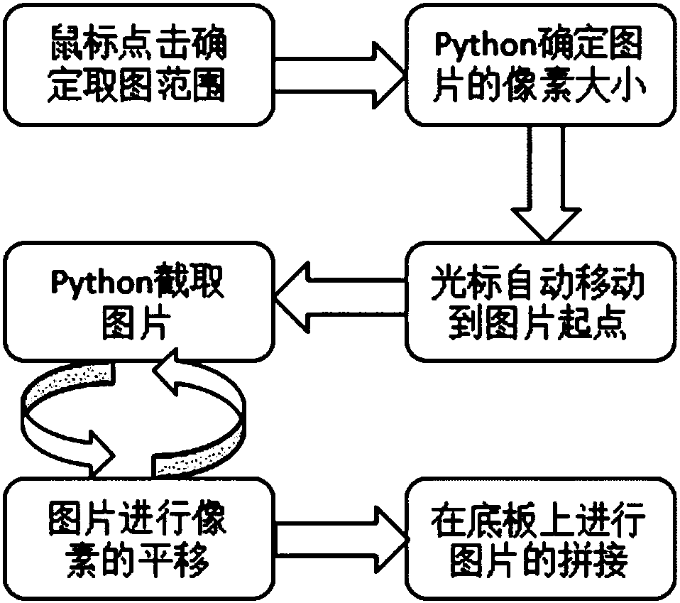
[0027] Such as figure 1 As shown, a method for automatically intercepting and splicing network map pictures based on the web-side API, including steps:

[0028] Step (1), according to the size of the picture you want, use the mouse to select the range of the captured picture on the network map. After determining the range of the picture, the user selects the zoom level of the map when the picture is taken;

[0029] Use the mouse to click the upper left corner of the target area, then move the cursor to the lower right, click the second point, and the line connecting the two points will be used as the diagonal line of the drawing rectangle; use the code of the "event binding" scene to bind the mouse Set the click event to obtain the coordinates of the four corners of the screenshot range; after determining the range of image capture, use the...


PUM


Abstract

The invention relates to a Web-end API (Application Programming Interface)-based method of automatically intercepting and splicing network map pictures, and belongs to the technical field of network application. According to the method, Python is used to interact with a Web end; and in picture intercepting, a mouse is first used to determine a picture intercepting range, a function of JavaScript is used to calculate pixels and the number of picture blocks in the picture intercepting range, then pixel translation of the picture blocks is carried out, circulation is carried out, and automatic splicing is carried out to form a completed electronic map of an intercepted region after sequential capturing of all the picture blocks is completed. Through the above process, the method can realize interception on any network map of a known region, and greatly satisfies needs of researchers for an any-size electronic map of each region in work of traffic planning and the like.

Description

technical field [0001] The invention belongs to the technical field of network applications, and in particular relates to a method for automatically intercepting and splicing network map pictures based on a Web terminal API. Background technique [0002] The automatic capture and stitching of network map pictures is an important network application technology. For transportation planners, they often need to capture a certain city map as a base map, and then use it in TransCAD for road calibration, display of surrounding landmarks, and calibration of physical bus stops. Network map is a public resource, and it is of great significance for GIS application and network application to accurately and unbiasedly intercept network map and apply it to the transportation field. [0003] In the early days when there was no online map or the online map was not mature enough, in order to obtain an electronic version of the map, the usual practice was to directly scan the paper tourist m...

Claims


Application Information

Patent Timeline
IPC IPC(8): G06F8/30G06F8/38G06T3/40G09B29/00
CPCG06F8/315G06F8/38G06T3/4038G09B29/007
Inventor 景鹏黄位徐刚
Owner JIANGSU UNIV
Why Eureka
Try Eureka