Location method of three-antenna interferometric delay Doppler radar altimeter topographical feature point

A technology of Doppler radar and positioning method, which is applied in the field of locating prominent points of topography of delayed Doppler radar altimeter, which can solve the problem of low matching positioning accuracy, affecting the improvement of radar altimeter resolution, and difficulty in extracting ground unit angle information, etc. problem, to achieve the effect of improving positioning accuracy, reducing the number of flights, and improving resolution

Active Publication Date: 2021-07-27
XIDIAN UNIV
View PDF6 Cites 0 Cited by
  • Summary
  • Abstract
  • Description
  • Claims
  • Application Information

AI Technical Summary

Problems solved by technology

However, the interferometric delay Doppler radar altimeter system developed by the United States is only a dual-antenna system. Since the echo signals of ground units with equal distances on the left and right sides of the route will overlap in one distance unit, this dual-antenna system is difficult to be effective. Extracting the angle information of the ground unit cannot distinguish the position information of the equidistant ground units on the left and right sides of the route, which in turn affects the improvement of the resolution of the radar altimeter in the direction perpendicular to the heading, resulting in low accuracy of matching and positioning, which cannot meet the requirements of terrain matching. need

Method used


Image

  • Location method of three-antenna interferometric delay Doppler radar altimeter topographical feature point
  • Location method of three-antenna interferometric delay Doppler radar altimeter topographical feature point
  • Location method of three-antenna interferometric delay Doppler radar altimeter topographical feature point

Examples


Embodiment Construction

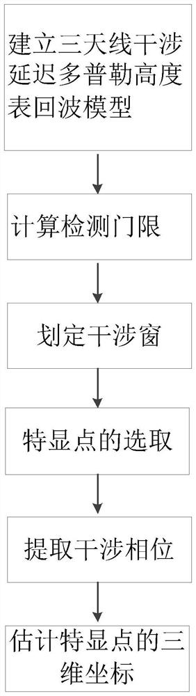
[0028] refer to figure 1 , the specific implementation steps of the present invention are as follows:

[0029] Step 1. Establish the echo signal model of the three-antenna interferometric delay Doppler radar altimeter.

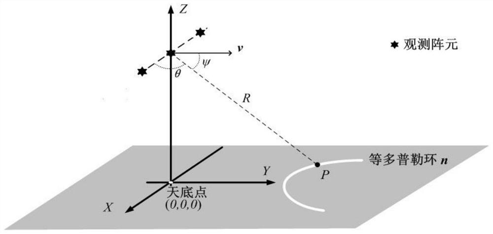
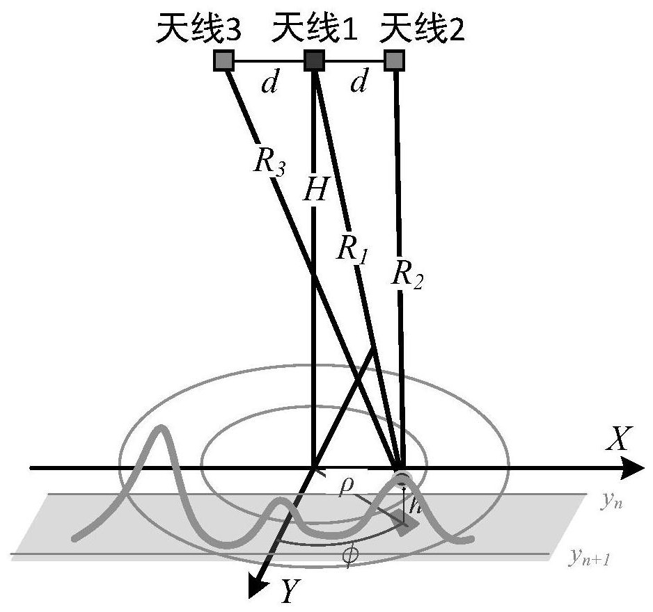
[0030] refer to image 3 , arrange three antennas at the same interval along the vertical course direction, and record the distance between the antennas, that is, the length of the baseline as d, where d>0, the height of the antenna from the ground is H meters, H>100, and point A is any One ground unit, the distance from the first antenna 1 to point A is R 1 , the distance from the second antenna 2 to point A is R 2 , the distance from the third antenna 3 to point A is R 3 , the angle between the antenna array normal and point A is θ, the distance between the coordinate origin and point A is ρ, the angle between the aircraft heading and point A is Φ, the pulse signal is sent by the first antenna 1, and the first antenna 1. The second antenna 2 and the thi...


PUM


Abstract

The invention discloses a three-antenna interference delay Doppler altimeter terrain characteristic point positioning method, which mainly solves the problems of high measurement accuracy and low ground resolution of the existing method. The implementation steps are: establish the echo signal model of the three-antenna interferometric delay Doppler radar altimeter; calculate the noise power estimation and detection threshold of the echo signal; delineate the interference window, and obtain all ground units whose amplitude values ​​are higher than the detection threshold; Select the prominent point and select the ground unit without aliasing; extract the interference phase to obtain the angle between the ground unit and the normal of the antenna array; according to the distance corresponding to the prominent point in the interference window, the special point relative to the normal and the angle between the center of the Doppler channel where the prominent point is located and the heading, and estimate the three-dimensional coordinates of the prominent point. The invention improves the measurement accuracy of the radar altimeter and the resolution in the vertical course direction, can select more prominent points and provide three-dimensional coordinate information, and can be used for positioning the target during terrain matching.

Description

technical field [0001] The invention relates to the field of radar technology, in particular to a method for locating prominent topographic points of a delayed Doppler radar altimeter, which can be used for locating targets during terrain matching. Background technique [0002] The existing inertial guidance methods generally rely on other correction equipment because the accumulated errors will increase with the flight time, and there is no self-correction function. Therefore, using terrain matching navigation system to correct inertial navigation system is a research hotspot at present, and the core of terrain matching navigation system is the altimeter, so higher requirements are put forward for the measurement resolution and measurement accuracy of the altimeter. The measurement accuracy and ground resolution of the traditional radar altimeter are low, but after using delayed Doppler processing, the resolution along the heading direction is improved, but the resolution i...

Claims


Application Information

Patent Timeline
Patent Type & Authority Patents(China)
IPC IPC(8): G01S13/88G01S13/89G01S7/41
CPCG01S7/41G01S13/88G01S13/89
Inventor 刘楠王璟琛刘战张林让郭凯斯葛改
Owner XIDIAN UNIV
Why Eureka
Try Eureka