A matching method for three dimensional laser point cloud data and unmanned aerial vehicle point cloud data

A point cloud data and three-dimensional laser technology, applied in the direction of using optical devices, measuring devices, instruments, etc., can solve the problems of missing point cloud data, inability to fully reflect the characteristic information of the target object, etc., and achieve the effect of reducing data missing

Active Publication Date: 2018-10-19
FUJIAN AGRI & FORESTRY UNIV
View PDF8 Cites 4 Cited by
  • Summary
  • Abstract
  • Description
  • Claims
  • Application Information

AI Technical Summary

Problems solved by technology

Although the use of UAVs and 3D laser scanners to obtain point cloud data is more common, one-way ground point cloud data or aerial point cloud data often have missing point cloud data, which cannot fully reflect the characteristic information of the target object.

Method used


Image

  • A matching method for three dimensional laser point cloud data and unmanned aerial vehicle point cloud data
  • A matching method for three dimensional laser point cloud data and unmanned aerial vehicle point cloud data
  • A matching method for three dimensional laser point cloud data and unmanned aerial vehicle point cloud data

Examples


Embodiment Construction

[0023] The present invention will be described in further detail below with reference to the accompanying drawings and specific embodiments.

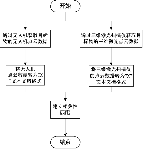
[0024] like figure 1 As shown, in this embodiment, the following steps are included:

[0025] Step S1: obtaining the drone point cloud data of the target through the drone;

[0026] Step S2: obtaining the three-dimensional laser point cloud data of the target through a three-dimensional laser scanner;

[0027] Step S3: Convert the 3D laser point cloud data and the UAV point cloud data into the same format;

[0028] Step S4: Using the drone point cloud data as the reference system and the 3D laser point cloud data as the mobile system, select multiple points with the same name based on the RGB color type based on the 3D point cloud data, and use the global matching method to match the point clouds of the two. Data builds correlation matching.

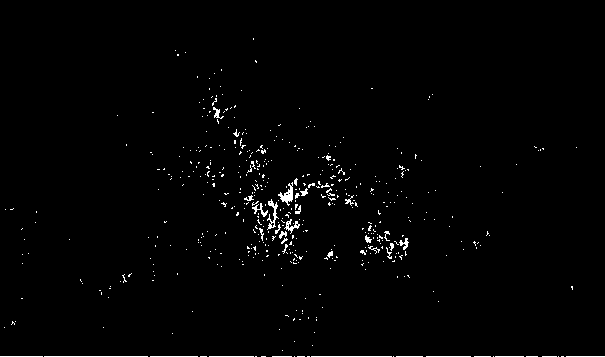
[0029] like figure 2 As shown, in this embodiment, the three-dimensional laser point clo...


PUM


Abstract

The invention relates to a matching method for three dimensional laser point cloud data and unmanned aerial vehicle point cloud data. The method includes the following steps: step S1: the unmanned aerial vehicle point cloud data of the target is obtained by the unmanned aerial vehicle; step S2: the three dimensional laser point cloud data of the target is obtained through a three dimensional laserscanner; step S3: the three dimensional laser point cloud data and the unmanned aerial vehicle point cloud data are converted to the same format; step S4: the unmanned aerial vehicle point cloud datais used as a reference system, the three dimensional laser point cloud data is used as a mobile system, multiple same points are selected based on the RGB color types of the three dimensional point cloud data, and the correlation matching is established according to the unmanned aerial vehicle point cloud data and the three dimensional point cloud data by utilizing a global matching mode. The method has effects that: ground-air integration is realized through the obtaining process of the point cloud data, the existence of data missing of the point cloud data unidirectionally obtained by the three dimensional laser or the unmanned aerial vehicle is reduced, and the more comprehensive data information of the target is provided for the research personnel.

Description

technical field [0001] The invention relates to a method for matching three-dimensional laser point cloud data and unmanned aerial vehicle point cloud data. Background technique [0002] At present, 3D laser and UAV point cloud data are developing rapidly in the field of forestry. Due to the needs of research, it is often necessary to accurately obtain the 3D structure information of the forest canopy. How to quickly and effectively obtain comprehensive point cloud data is particularly important. Although the use of drones and 3D laser scanners to obtain point cloud data is more common, the one-way ground point cloud data or aerial point cloud data often lacks point cloud data, which cannot fully reflect the characteristic information of the target. . SUMMARY OF THE INVENTION [0003] The present invention improves the above problems, that is, the technical problem to be solved by the present invention is to realize the matching of ground and empty point cloud data and ob...

Claims


Application Information

Patent Timeline
IPC IPC(8): G01B11/00
CPCG01B11/002
Inventor 余坤勇刘健邓洋波谢巧雅
Owner FUJIAN AGRI & FORESTRY UNIV
Why Eureka
Try Eureka