
Remote sensing identification method and device for grassland salinization and computer readable storage medium

A technology of remote sensing identification and salinization, which is applied in the field of remote sensing technology and environmental investigation, and can solve problems such as difficult to obtain conveniently and quickly

Inactive Publication Date: 2018-11-20
INNER MONGOLIA M GRASS ECOLOGY & ENVIROMENT GRP CO LTD +2
View PDF1 Cites 5 Cited by
  • Summary
  • Abstract
  • Description
  • Claims
  • Application Information

AI Technical Summary

Problems solved by technology

They require a variety of data types for soil nutrient detection, but due to geographical conditions and detection technology limitations, it is actually difficult to obtain convenient and quick

Method used


Image

  • Remote sensing identification method and device for grassland salinization and computer readable storage medium
  • Remote sensing identification method and device for grassland salinization and computer readable storage medium
  • Remote sensing identification method and device for grassland salinization and computer readable storage medium

Examples


Embodiment 1

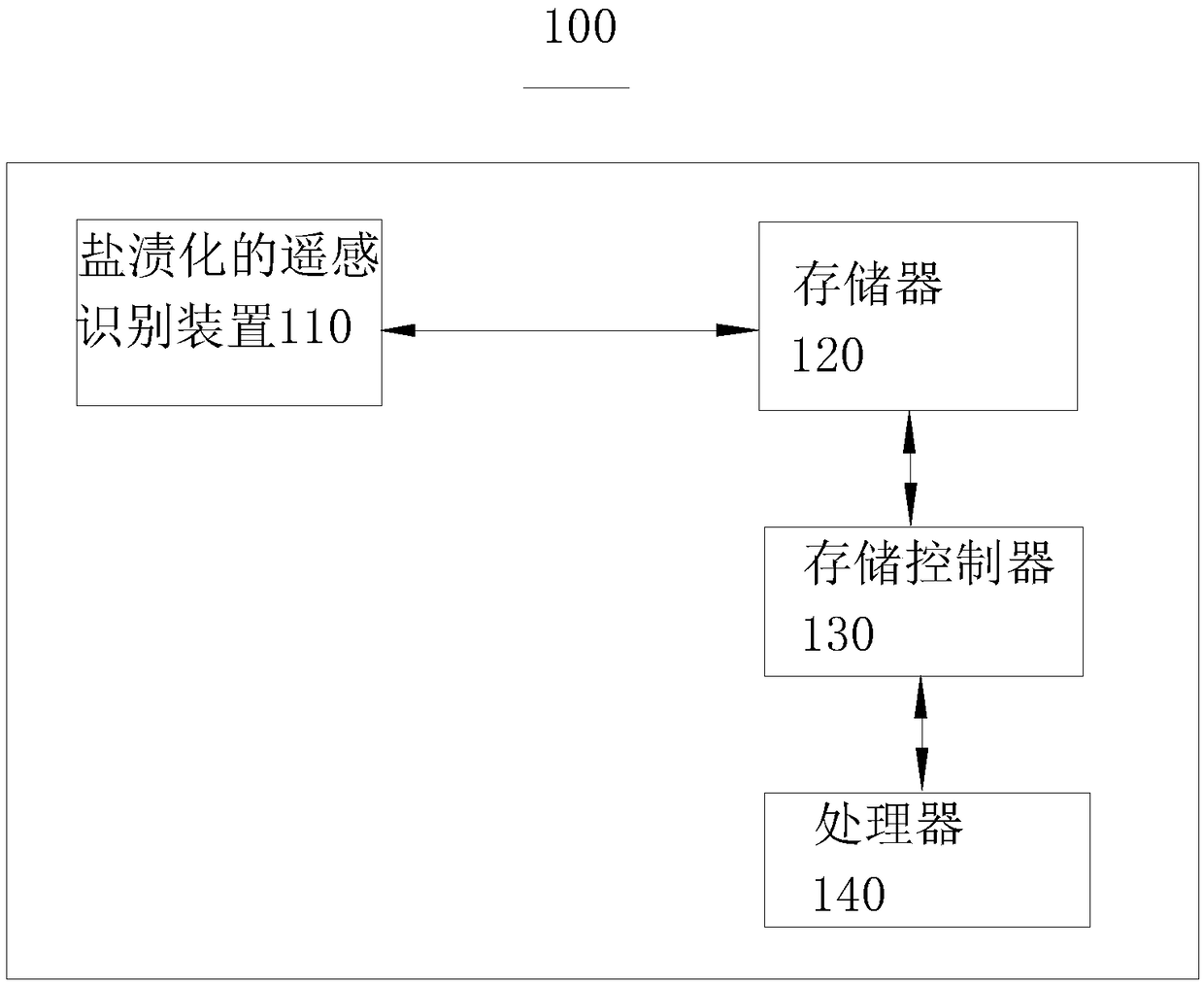
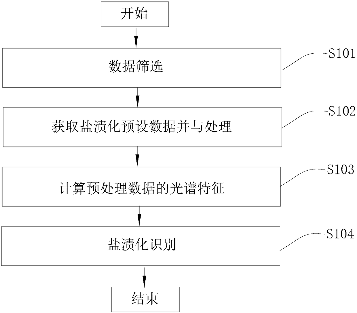
[0058] refer to figure 2 , this embodiment provides a remote sensing identification method for grassland salinization applied to the above-mentioned electronic device 100, which will be combined below figure 2 Describe the steps involved.

[0059] Step S101: Data screening

[0060] According to the growth characteristics of grass, combined with the requirements of spatial resolution and cloud cover, we need to select appropriate image data to meet the obvious distinction of different surface types; and regional meteorological data in the past 30 years.

[0061] Step S102: Obtain the preset data of salinization and perform preprocessing

[0062] Image data and processing, patching of default, cloudy areas. Meteorological data preprocessing, repair of abnormal data such as default and outliers. Basic local survey information such as humanities, hydrology, and landforms. Get preprocessed data.

[0063] Step S103: Calculate the spectral features of the preprocessed data

...


PUM


Abstract

The invention provides a remote sensing identification method and device for grassland salinization and a computer readable storage medium, and belongs to the field of a remote sensing technology andenvironment survey. Preprocessing is carried out by existing salinization data, spectral features are obtained and used as feature input quantities, then computer learning is carried out, and an identification model is established; data of a to-be-detected region is identified by the model to obtain a salinization region; the identification device for salinization can rapidly and accurately identify the salinization region; and the computer readable storage medium can conveniently execute the identification method to obtain related data and then obtain data of the salinization region.

Description

technical field [0001] The invention relates to the field of remote sensing technology and environmental investigation, in particular to a remote sensing identification method, device and computer-readable storage medium for grassland salinization. Background technique [0002] There are usually two ways to identify salinized areas. One is the method of obtaining soil parameters through field sampling, and the apparent conductivity of the soil is measured by an electronic induction conductivity tester, and finally the salinization situation is evaluated; the other method is through the interpretation of remote sensing images. Field sampling technology is mature and has high precision, but the acquisition cost of data sources is high, and it is difficult to monitor and identify a large area. The data of remote sensing images are easy to obtain, which is conducive to large-scale identification, and has the characteristics of multi-band and multi-time span. [0003] By combin...

Claims


Application Information

Patent Timeline
IPC IPC(8): G06K9/00G06K9/62
CPCG06V20/194G06V20/13G06F18/24
Inventor 王保林张弓苏德高娃白耀华杜鹏邢旗张贵花赵冠华张艳忠
Owner INNER MONGOLIA M GRASS ECOLOGY & ENVIROMENT GRP CO LTD
Learn More