Ground user navigation and positioning method based on Beidou ka inter-satellite link signal

An inter-satellite link, navigation and positioning technology, applied to satellite radio beacon positioning systems, instruments, measuring devices, etc., can solve the problems of navigation service performance degradation and failure

Active Publication Date: 2019-05-14
WENZHOU UNIVERSITY
View PDF6 Cites 0 Cited by
  • Summary
  • Abstract
  • Description
  • Claims
  • Application Information

AI Technical Summary

Problems solved by technology

[0004] Aiming at the problem that the L-band signal of GNSS is susceptible to intentional or unintentional interference and spoofing, which leads to the degradation or even failure of ground regional navigation service performance, the present invention proposes a ground user navigation and positioning method based on the Beidou Ka inter-satellite link signal, This method uses the receiver clock model and the inertial navigation system to reduce the distance values ​​measured at different times to the same time to realize the time synchronization of the ranging values, and then use the Kalman filter algorithm to estimate the ground user position in real time

Method used


Image

  • Ground user navigation and positioning method based on Beidou ka inter-satellite link signal
  • Ground user navigation and positioning method based on Beidou ka inter-satellite link signal
  • Ground user navigation and positioning method based on Beidou ka inter-satellite link signal

Examples


Embodiment

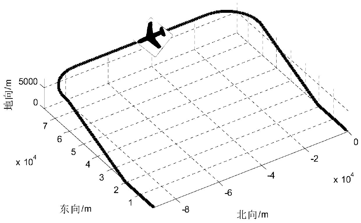
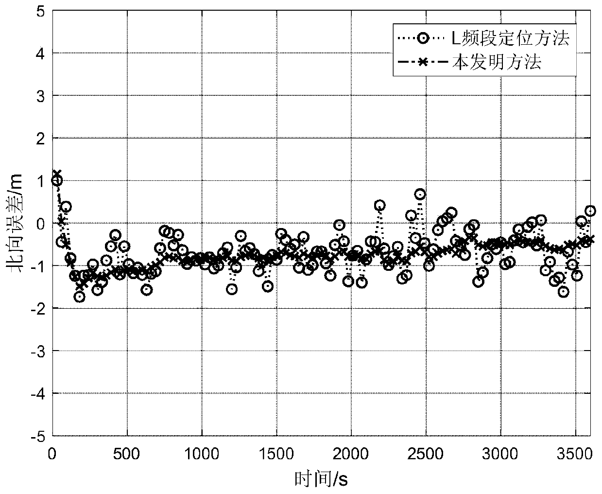
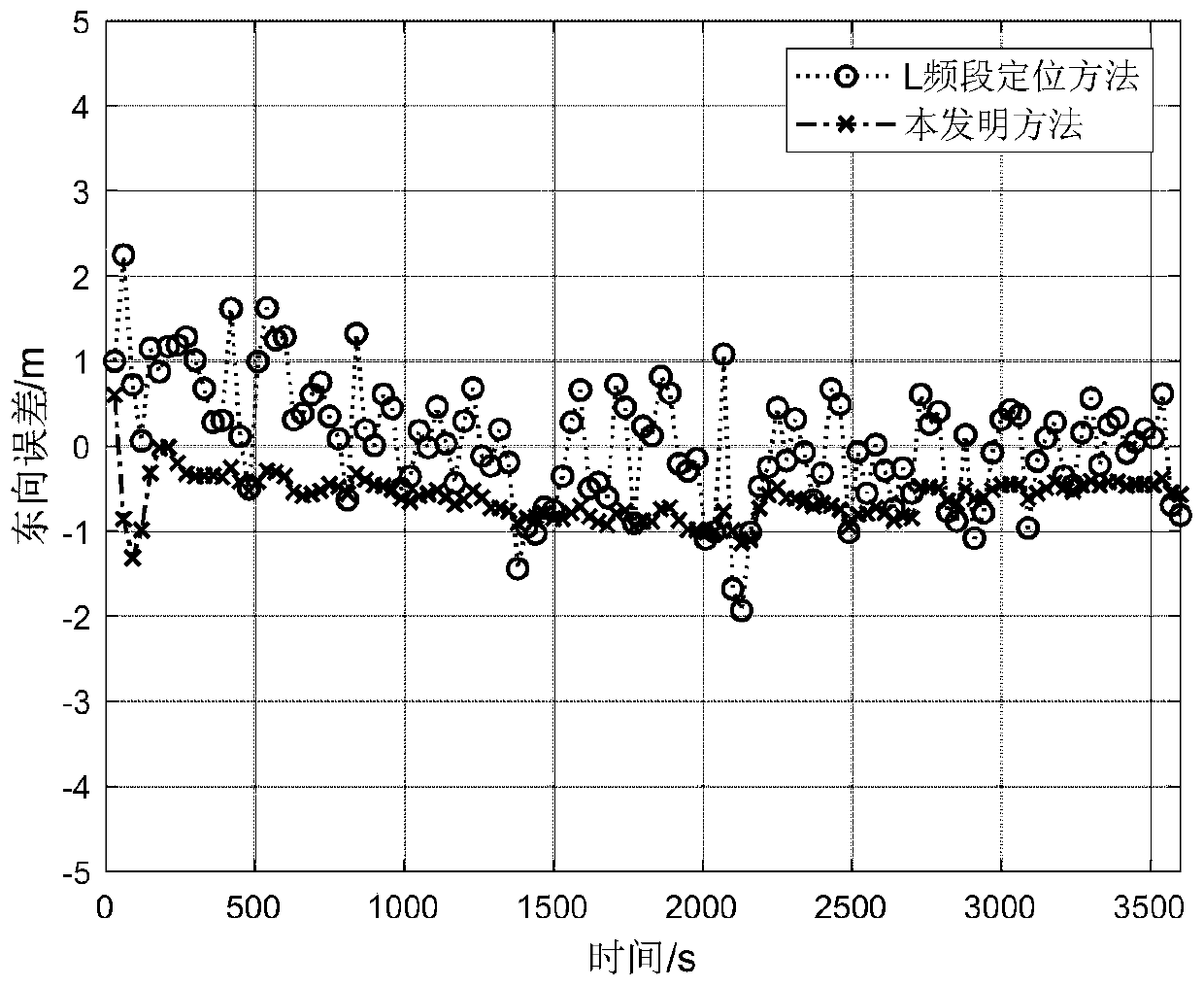
[0135] Utilize the data that track generator produces to carry out emulation verification to the inventive method, motion track is as figure 1 As shown, the initial position is set to 110° east longitude, 30° north latitude, and 0m altitude, the initial roll angle, pitch angle, and heading angle are all 0°, and the initial speed in the east, north, and sky directions is 0m / s . Without loss of generality, the motion process includes uniform acceleration linear motion, uniform speed linear motion, climbing, contour turning, diving, etc., and the duration is 3600s. At the same time, it is assumed that the zero bias of the three gyroscopes in the inertial navigation system is 0.1° / h, the random drift is 0.1° / h, and the zero bias of the three accelerometers is 10- 4 g, the random drift is 10- 4 g, The random error of the receiver clock is 0.1m, and the error of the tropospheric model is 0.5m. Using precise ephemeris (including precise orbit ephemeris and precise clock ephemeris)...


PUM


Abstract

The present invention provides a ground user navigation and positioning method based on the Beidou Ka inter-satellite link signal, comprising the following steps: (1) assuming that between k-1 and k two epochs, where k=1,2,3, ..., users equipped with Beidou inter-satellite link signal receiving terminals in a certain area on the ground generate inter-satellite link one-way ranging values ​​with N different Beidou satellites at different times, thereby obtaining N ranging equations; (2) using the receiving The machine clock model and inertial navigation information will uniformly reduce the user position in the ranging equation to T k (3) On the basis of realizing the time synchronization of the ranging value, ground users use the Kalman filter positioning algorithm to estimate their position in real time. The invention can avoid the interference source and deception source for the L-band navigation signal, compensate the usability problem caused by the failure of the L-band navigation signal to a certain extent, and ensure the navigation safety of key areas in special scenarios.

Description

technical field [0001] The invention relates to a ground user navigation and positioning method, in particular to a ground user navigation and positioning method based on the Beidou Ka inter-satellite link signal. Background technique [0002] Global Navigation Satellite System (GNSS) has become an important space infrastructure for expanding human activities and promoting social development. Accuracy, integrity, continuity and availability are the four key indicators of GNSS. Wherein, usability means that users of the navigation system can obtain their own location information according to the received navigation signals. Traditional L-band navigation signals are vulnerable to various intentional or unintentional interference and deception, especially some key areas and sensitive areas, which will become the targets of various interference sources and deception sources in special periods, resulting in L-band navigation signals in the The navigation performance in this are...

Claims


Application Information

Patent Timeline
Patent Type & Authority Patents(China)
IPC IPC(8): G01S19/47G01S19/21
CPCG01S19/21G01S19/47
Inventor 李理敏项佳豪肖洋姜兴龙梁广龚文斌余金培
Owner WENZHOU UNIVERSITY
Why Eureka
Try Eureka