GNSS level measuring method

A leveling and leveling technology, applied in height/leveling measurement, measuring devices, surveying and navigation, etc., can solve the problems of heavy workload in field surveying, achieve the effect of improving the efficiency of surveying operations and reducing workload

Active Publication Date: 2018-11-30
CHINA MAJOR BRIDGE ENERGINEERING
View PDF4 Cites 5 Cited by
  • Summary
  • Abstract
  • Description
  • Claims
  • Application Information

AI Technical Summary

Problems solved by technology

[0006] The technical problem to be solved by the present invention is that in the current leveling survey, the survey regulations that require round-trip observation and form a combined route or a closed loop line lead to a larger workload in field surveys

Method used


Image

  • GNSS level measuring method
  • GNSS level measuring method
  • GNSS level measuring method

Examples


Embodiment Construction

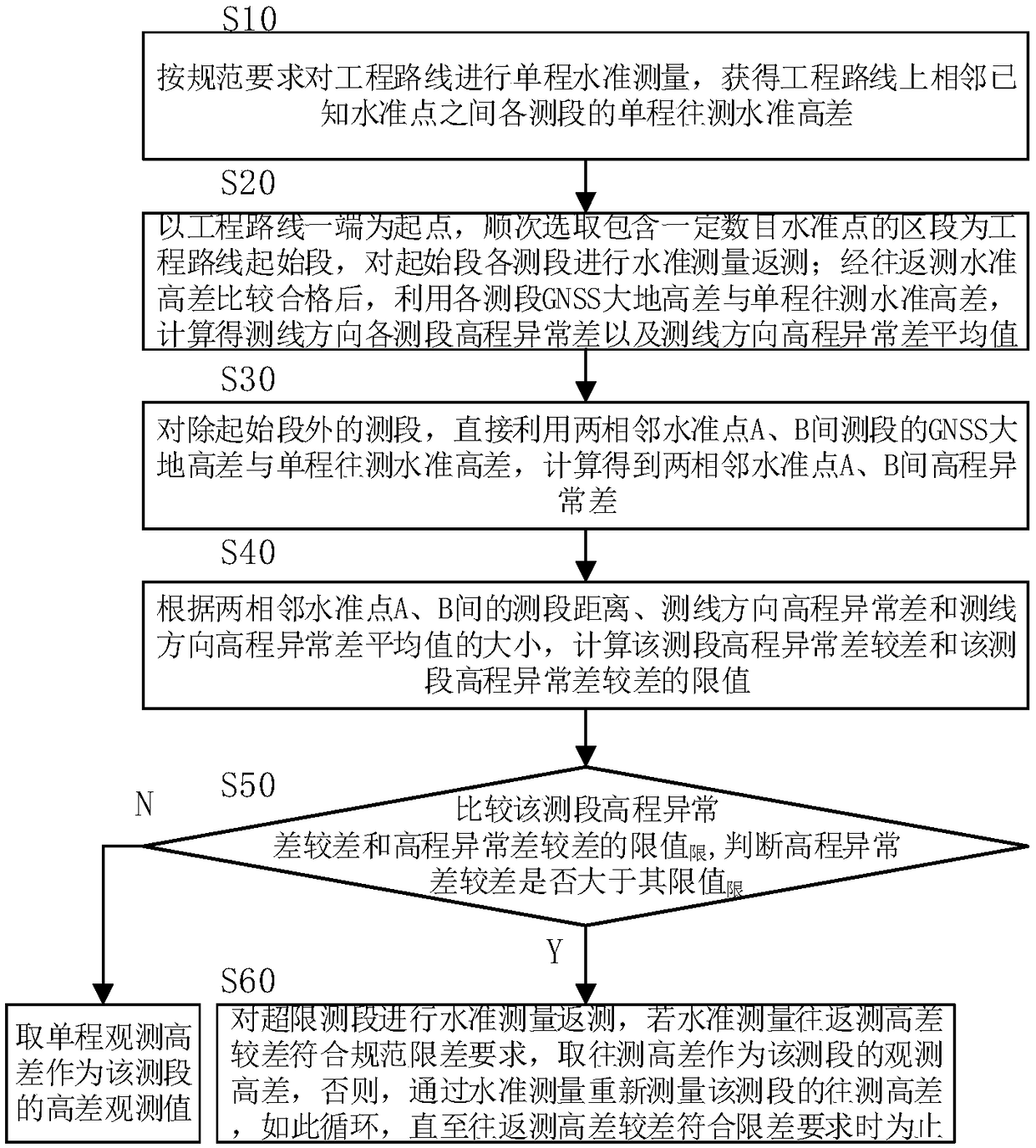
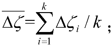
[0049] In particular, it relates to a GNSS leveling measurement method, which is suitable for elevation control measurement of linear engineering such as roads, railways, and power pipelines.

[0050] In the current leveling survey, when the elevation accuracy of known points is low or the elevations are incompatible between two or more known points, the practice of fixing the elevation of known points and forcibly assigning the closure difference will lose and reduce the actual accuracy of leveling measurement , it is better to directly use the one-way observation height difference to calculate the elevation of each point. For example: a highway engineering project in Africa, the total length of the route is more than 400 kilometers, and the total length of the one-way leveling route is more than 600 kilometers. The measurement is carried out according to the fourth-class leveling accuracy. Contains a large gross error, and the compatibility between known points is extremely ...


PUM


Abstract

The invention discloses a GNSS level measuring method. The GNSS level measuring method comprises the following steps: performing the single-pass level measurement according to the regulation requirements, and acquiring an observation value of a single-pass level measurement height difference of each measured section; when a discrepancy of an observation height difference and a known height difference between the known level points is out of limit, or no other known level point can be provided for the closed tie measurement in a distance range stipulated by the regulation, checking the qualityof the single-pass level measurement result by utilizing the GNSS plane control measurement geodetic height data, discovering and correcting a measurement gross error and a mistake, so that the levelmeasurement back measurement can be avoided. According to the method, the GNSS plane control measurement data is used for checking the accuracy and reliability of a single-pass level measurement result, so that the level measurement operation workload can be greatly reduced, and the measurement operation efficiency can be improved.

Description

technical field [0001] The invention relates to the technical field of elevation control measurement, in particular to a GNSS (Global Navigation Satellite System, Global Navigation Satellite System) leveling measurement method. Background technique [0002] Leveling is a method of measuring the height difference between two points on the ground using a level and a leveling rod; leveling is usually measured from a leveling point or any known point to measure the height of other points. There are 4 grades of first class and fourth class. The current leveling standards are: GBT12897-2006 national first and second level leveling standards and GBT12898-2009 national third and fourth level leveling standards. [0003] The current survey regulations stipulate that the first, second and third level surveys must be observed in a single route, and form a joint route or a closed loop to form a network graph; On the known point or closed by itself and meet the tolerance requirements, o...

Claims


Application Information

Patent Timeline
Patent Type & Authority Applications(China)
IPC IPC(8): G01C5/00
CPCG01C5/00
Inventor 吴迪军熊伟李剑坤张建军林训根
Owner CHINA MAJOR BRIDGE ENERGINEERING
Why Eureka
Try Eureka